more stats
728 ft
Distance
127 ft
Climb
00:03:00
Avg time
131 ft
Altitude change
1,413 ft
Altitude min
1,544 ft
Altitude max
1,413 ft
Altitude start
1,545 ft
Altitude end
18%
Grade
34.2%
Grade min
682 ft
Distance climb
46 ft
Distance flat
00:03:00
Avg time

Push Up Details

  • Activities
    • Mountain Bike
    • E-Bike
    • Gravel Bike
    • Hike
    • Trail Running
  • Riding Area
    Traquair Trails
    Innerleithen
  • Difficulty Rating
  • Hiking SAC Scale
    T1 Hiking
  • Trail Type
    Machine Groomed
  • Bike Type
    DH, AM, XC, Gravel
  • Direction
    Uphill Primary[+]
    Popular Direction Shown
    • Uphill Primary for Gravel Biking
  • Climb Difficulty
    Black Diamond
  • Physical Rating
    Hard
  • Trail Visibility
    Always easy to follow
  • Dogs Allowed
    Yes
  • eBike Allowed
    Yes up to Class 1
  • Ride in Rain
    Yes

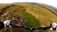
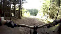
Push up from the forest road to the start of the DH trails and some Enduro trails. Push up that really fit people ride up.

Access Info

Signposted from the DH push up. Not far from the uplift turning circle. Few minutes pedal from the start of Plora Craig for the more adventurous XC rider.

Bike Park

Local Trail Association

Recent Activity on Trail

Past Week
  • 1 rides
  • 27 miles average
6 Months
  • 54 rides
  • 22 miles avg distance
All
  • 431 rides
  • Last: Jun 14, 2026
c1c2c3c4
January
February
March
April
May
June
July
August
September
October
November
December
update trails status or condition

Push Up Trail Reports

Status:
on May 25, 2026
Variable
Avg: 3.72 (5 votes)
Your vote: 0

view (5,554)
close
3D
Trail Conditions
  • Unknown
  • Snow Groomed
  • Snow Packed
  • Snow Covered
  • Snow Cover Partial
  • Freeze/thaw Cycle
  • Icy
  • Prevalent Mud
  • Wet
  • Variable
  • Ideal
  • Dry
  • Very Dry
Trail Flow (Ridden Direction)
Trailforks scans users ridelogs to determine the most popular direction each trail is ridden. A good flowing trail network will have most trails flowing in a single direction according to their intension.
The colour categories are based on what percentage of riders are riding a trail in its intended direction.
  • > 96%
  • > 90%
  • > 80%
  • > 70%
  • > 50%
  • < 50%
  • bi-directional trail
  • no data
Trail Last Ridden
Trailforks scans ridelogs to determine the last time a trail was ridden.
  • < 2 days
  • < 1 week
  • < 2 weeks
  • < 1 month
  • < 6 months
  • > 6 months
Trail Ridden Direction
The intended direction a trail should be ridden.
  • Downhill Only
  • Downhill Primary
  • Both Directions
  • Uphill Primary
  • Uphill Only
  • One Direction
Contribute Details
Colors indicate trail is missing specified detail.
  • Description
  • Photos
  • Description & Photos
  • Videos
Trail Popularity ?
Trailforks scans ridelogs to determine which trails are ridden the most in the last 9 months. Trails are compared with nearby trails in the same city region with a possible 25 colour shades. Think of this as a heatmap, more rides = more kinetic energy = warmer colors.
  • most popular
  • popular
  • less popular
  • not popular
ATV/ORV/OHV Filter
Max Vehicle Width
inches
US Cell Coverage
Legend
cell carrier legend

Radar Time
Activity Recordings
Trailforks uses anonymized public activity data. ?
Activity Recordings
Trailforks uses anonymized public activity data. ?
Personal Heatmap
Activity Types
all / none
Options
2
Date range month
Winter Trails
Warning A routing network for winter maps does not exist. Selecting trails using the winter trails layer has been disabled.
Missing Trails
Most Popular
Least Popular
Trails are colored based on popularity. The more popular a trail is, the more red. Less popular trails trend towards green.
Jump Magnitude Heatmap
Heatmap of where riders jump on trails. Zoom in to see individual jumps, click circles to view jump details.
BC Backroad Status

Service Road Atlas is a free to use, community-driven service for viewing and creating reports on the numerous back-country service roads around B.C. and Alberta.

map legend
Slope Aspect
Direction the slope faces
Flat N NE E SE S SW W NW
Trails Deemphasized
Trails are shown in grey.
disable
Only show trails with no bike usage.
Enable
Suggested Layers
Based on selected activity type

    Save the current map location and zoom level as your default home location whenever this page is loaded.

    Save
        Directions to push-up trailhead (55.608350, -3.036710)

        Photos

        27 more »
        230 |
        Dec 17, 2007 @ 10:53am
        Dec 17, 2007
        245 |
        May 2, 2008 @ 6:27am
        May 2, 2008
        254 |
        Nov 4, 2008 @ 1:52pm
        Nov 4, 2008
        190 |
        Nov 4, 2008 @ 1:54pm
        Nov 4, 2008

        Videos

        10 more »
        Illgill  Head, Whin Rigg, Irton Pike
        9:51 | 339 | Aug 16, 2014 , Innerleithen
        Innerleithen - Cresta Run
        4:04 | 250 | Sep 25, 2013 , Innerleithen
        Get out and ride
        0:28 | 133 | Apr 19, 2014 , Innerleithen
        Headcam test at Cramond
        0:53 | 62 | Jan 18, 2010 , Innerleithen

        Routes with this trail

        Big Beastie Featured
        5.0 50 miles 9,176 ft 26 Point to Point
        Unofficial Point to Point route taking in some of the best, and most technical singletrack of the Tweed...
        4.0 50 miles 10,325 ft 41
        Featuring the best trails of the tweed valley in one epic loop
        52 miles 10,606 ft 30 Point to Point
        Big Beastie route. One for the fitter riders

        Reviews / Comments

        No reviews yet, be the first to write a review or ask a question.
        Use trail reports to comment on trail conditions.


        We hope you've been enjoying Trailforks!

        Create a FREE account to view trail comments and much more.

        Nearby Trails

        • By 20twenty-pTF Pro TVTA & contributors
        • #22490 - 3,318 views

        Frequently Asked Questions About Push Up

        Where is Push Up located?
        Push Up is located in Traquair Trails, Innerleithen, United Kingdom. It is part of the Traquair Trails trail network. The trailhead is located at coordinates 55.60835, -3.03671.
        What is the elevation gain for Push Up?
        Push Up has 127 ft of elevation gain. The elevation ranges from 1,413 ft to 1,544 ft.
        Is Push Up a point to point trail?
        Push Up is not a point to point trail. The direction is Uphill Primary. The trail type is machine groomed.
        How long is Push Up?
        Push Up is 728 ft long. The trail type is machine groomed.

        Hit the Trail

        Open in App

        Get this trail on your phone instantly.
        open trail in app

        Download Trail

        Save to wishlist, Garmin & download.
        save the trail

        Find Related Routes

        Find routes and users activities that include this trail.
        find routes for this trail

        You must enter a description before submitting.