more stats
1.1 miles
Distance
4 ft
Climb
-1,310 ft
Descent
00:19:50
Avg time
-1,306 ft
Altitude change
175 ft
Altitude min
1,483 ft
Altitude max
1,483 ft
Altitude start
177 ft
Altitude end
-23.2%
Grade
-85.4%
Grade max
2.3%
Grade min
135 ft
Distance climb
5,236 ft
Distance down
256 ft
Distance flat
00:19:50
Avg time

Putakari Details

  • Activities
    • Mountain Bike
    • E-Bike
  • Riding Area
  • Difficulty Rating
  • Local Popularity
    40 in Mountain Biking
  • Global Ranking
    #79226 in Mountain Biking
  • Trail Type
    Singletrack
  • Bike Type
    DH, AM
  • Physical Rating
    Hard
  • Season
    All year - greasy in the wet though
  • Dogs Allowed
    Yes
  • eBike Allowed
    Yes up to Class 1
  • TTFs on Trail
    Rock Garden
  • Year Opened
    2016
  • Land Owner
    Tasman Pine

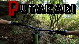
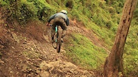
Putakari means "battle" in te reo Māori. A tight, native, singletrack trail with drop corners, rocks, a few jumps and a whole heap of awesome. Built by HayHay, Loui, Dan, Nathan and a whole heap of others. New trail grade in 2021.

Access Info

This trail is maintained by the Nelson Mountain Bike Club. Please consider supporting the club.

Recent Activity on Trail

Past Week
  • 0 rides
  •  
6 Months
  • 0 rides
  •  
All
  • 41 rides
  • Last: Dec 25, 2025
c1c2c3c4
January
February
March
April
May
June
July
August
September
October
November
December
update trails status or condition

Putakari Trail Reports

statusdatedescription
Jan 5, 2026 @ 1:50pm (Pacific/Auckland)
Jan 4, 2026
reporter Closed due to a large number of trees down. Please avoid this area.
Jan 2, 2026 @ 3:30pm (Pacific/Auckland)
Jan 1, 2026
Upper putakari is messy lots of debris and fallen trees somewhat manageable to repair, a lot of work however. Lower putakari is unrecognizable,...
Nov 23, 2025 @ 4:36pm (Pacific/Auckland)
Nov 22, 2025
Ongaonga getting pretty hard to avoid when riding the upper part of the trail. Take care, some of it is close to your face in places. General...
Oct 24, 2025 @ 8:42am (Pacific/Auckland)
Oct 23, 2025
Oct 10, 2025 @ 6:47pm (Pacific/Auckland)
Oct 9, 2025
reporter Open for recreational access
more »
Status:
on Jan 5, 2026
Dry
Avg: 4.57 (13 votes)
Your vote: 0

view (899)
close
3D
Trail Conditions
  • Unknown
  • Snow Groomed
  • Snow Packed
  • Snow Covered
  • Snow Cover Partial
  • Freeze/thaw Cycle
  • Icy
  • Prevalent Mud
  • Wet
  • Variable
  • Ideal
  • Dry
  • Very Dry
Trail Flow (Ridden Direction)
Trailforks scans users ridelogs to determine the most popular direction each trail is ridden. A good flowing trail network will have most trails flowing in a single direction according to their intension.
The colour categories are based on what percentage of riders are riding a trail in its intended direction.
  • > 96%
  • > 90%
  • > 80%
  • > 70%
  • > 50%
  • < 50%
  • bi-directional trail
  • no data
Trail Last Ridden
Trailforks scans ridelogs to determine the last time a trail was ridden.
  • < 2 days
  • < 1 week
  • < 2 weeks
  • < 1 month
  • < 6 months
  • > 6 months
Trail Ridden Direction
The intended direction a trail should be ridden.
  • Downhill Only
  • Downhill Primary
  • Both Directions
  • Uphill Primary
  • Uphill Only
  • One Direction
Contribute Details
Colors indicate trail is missing specified detail.
  • Description
  • Photos
  • Description & Photos
  • Videos
Trail Popularity ?
Trailforks scans ridelogs to determine which trails are ridden the most in the last 9 months. Trails are compared with nearby trails in the same city region with a possible 25 colour shades. Think of this as a heatmap, more rides = more kinetic energy = warmer colors.
  • most popular
  • popular
  • less popular
  • not popular
ATV/ORV/OHV Filter
Max Vehicle Width
inches
US Cell Coverage
Legend
cell carrier legend

Radar Time
Activity Recordings
Trailforks uses anonymized public activity data. ?
Activity Recordings
Trailforks uses anonymized public activity data. ?
Personal Heatmap
Activity Types
all / none
Options
2
Date range month
Winter Trails
Warning A routing network for winter maps does not exist. Selecting trails using the winter trails layer has been disabled.
Missing Trails
Most Popular
Least Popular
Trails are colored based on popularity. The more popular a trail is, the more red. Less popular trails trend towards green.
Jump Magnitude Heatmap
Heatmap of where riders jump on trails. Zoom in to see individual jumps, click circles to view jump details.
BC Backroad Status

Service Road Atlas is a free to use, community-driven service for viewing and creating reports on the numerous back-country service roads around B.C. and Alberta.

map legend
Slope Aspect
Direction the slope faces
Flat N NE E SE S SW W NW
Trails Deemphasized
Trails are shown in grey.
disable
Only show trails with no bike usage.
Enable
Suggested Layers
Based on selected activity type

    Save the current map location and zoom level as your default home location whenever this page is loaded.

    Save
        Directions to putakari trailhead (-41.265300, 173.325380)

        Photos

        28 more »
        73 |
        Jun 22, 2023 @ 1:04pm
        Jun 22, 2023
        54 |
        Jun 22, 2023 @ 1:04pm
        Jun 22, 2023
        99 |
        Oct 10, 2020 @ 1:53am
        Oct 10, 2020
        232 |
        Nov 11, 2018 @ 1:05am
        Nov 11, 2018

        Videos

        3 more »
        Downhill battle on Putakari on a beautiful...
        8:46 | 196 | Jan 1, 2024 , Nelson
        Aorere Enduro - Putakari
        5:58 | 1102 | Nov 29, 2018 , Nelson
        Cloud nine
        3:41 | 1382 | Apr 22, 2017 , Nelson

        Routes with this trail

        37 miles 10,048 ft 17 Race
        The epic 2024 Mammoth Course
        37 miles 10,232 ft 16 Race
        The epic 2024 Mammoth Course

        4 Reviews & Comments


        We hope you've been enjoying Trailforks!

        Create a FREE account to view trail comments and much more.

        • By NMTBCTF Pro NMTBC & contributors
        • #76421 - 6,256 views

        Frequently Asked Questions About Putakari

        Where is Putakari located?
        Putakari is located in Waitarake/Sharlands, Nelson, New Zealand. It is part of the Waitarake/Sharlands trail network. The trailhead is located at coordinates -41.2653, 173.32538.
        How hard is Putakari?
        Putakari is rated as Double Black Diamond difficulty. The physical rating is Hard. The average grade is 23.2%.
        What is the elevation gain for Putakari?
        Putakari has 1 m of elevation gain. The trail has 399 m of elevation descent. The elevation ranges from 53 m to 452 m.
        How long is Putakari?
        Putakari is 1.7 km long. The trail type is singletrack.

        Hit the Trail

        Open in App

        Get this trail on your phone instantly.
        open trail in app

        Download Trail

        Save to wishlist, Garmin & download.
        save the trail

        Find Related Routes

        Find routes and users activities that include this trail.
        find routes for this trail

        You must enter a description before submitting.