more stats
1.8 miles
Distance
-1,300 ft
Descent
00:18:02
Avg time
-1,300 ft
Altitude change
1,824 ft
Altitude min
3,124 ft
Altitude max
3,124 ft
Altitude start
1,824 ft
Altitude end
-13.471%
Grade
-34.926%
Grade max
0.394%
Grade min
2 miles
Distance down
203 ft
Distance flat
00:18:02
Avg time

Python Details

  • Activities
    • Mountain Bike
  • Riding Area
    Veľká Javorina
    Nove Mesto nad Vahom
  • Difficulty Rating
  • Local Popularity
    30 in Mountain Biking
  • Global Ranking
    #123214 in Mountain Biking
  • Trail Type
    Singletrack
  • Bike Type
    DH, AM, XC
  • Direction
    Downhill Primary
    Popular Direction Shown
  • Season
    full season / except snowy conditions/
  • Dogs Allowed
    Yes
  • TTFs on Trail
    Drop, Gap Jump
  • Ride in Rain
    Yes
  • Year Opened
    2017

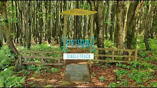
Quite fast singletrack, some off-camber root sections and natural drops.

Access Info

By car: Veľká Javorina parking lot near the cottage up on the hill, then follow turist path marked red up the ridge.

Recent Activity on Trail

Past Week
  • 0 rides
  •  
6 Months
  • 0 rides
  •  
All
  • 2 rides
  • Last: Apr 25, 2026
c1c2c3c4
January
February
March
April
May
June
July
August
September
October
November
December
update trails status or condition

Python Trail Reports

statusdatedescription
Apr 30, 2026 @ 9:11pm (Europe/Bratislava)
Apr 30, 2026
zaver od krizovania zo zvaznicou som netrafil/ nenasiel. Ale potial v super stave
Apr 25, 2026 @ 3:00pm (Europe/Bratislava)
Apr 25, 2026
Major erosion (major ruts or slumping, large boulders and roots exposed due to erosion). It starts lovely in the forest but later stages are...
Jul 19, 2025 @ 10:04am
Jul 19, 2025
Zarastené vysokou trávou asi tak 70 percent trailu
Jul 17, 2024 @ 1:09am
Jul 17, 2024
Overgrown vegetation outside of the forrest
Apr 9, 2024 @ 3:52am
Apr 9, 2024
Python plne prejazdný a v relatívne dobrej kondícii. Úsek, kde sa stretáva so žltou turistickou značkou je rozjazdený od techniky, ale v...
more »
Status:
on Apr 30, 2026
Dry
Avg: 4.21 (8 votes)
Your vote: 0

view (94)
close
3D
Trail Conditions
  • Unknown
  • Snow Groomed
  • Snow Packed
  • Snow Covered
  • Snow Cover Partial
  • Freeze/thaw Cycle
  • Icy
  • Prevalent Mud
  • Wet
  • Variable
  • Ideal
  • Dry
  • Very Dry
Trail Flow (Ridden Direction)
Trailforks scans users ridelogs to determine the most popular direction each trail is ridden. A good flowing trail network will have most trails flowing in a single direction according to their intension.
The colour categories are based on what percentage of riders are riding a trail in its intended direction.
  • > 96%
  • > 90%
  • > 80%
  • > 70%
  • > 50%
  • < 50%
  • bi-directional trail
  • no data
Trail Last Ridden
Trailforks scans ridelogs to determine the last time a trail was ridden.
  • < 2 days
  • < 1 week
  • < 2 weeks
  • < 1 month
  • < 6 months
  • > 6 months
Trail Ridden Direction
The intended direction a trail should be ridden.
  • Downhill Only
  • Downhill Primary
  • Both Directions
  • Uphill Primary
  • Uphill Only
  • One Direction
Contribute Details
Colors indicate trail is missing specified detail.
  • Description
  • Photos
  • Description & Photos
  • Videos
Trail Popularity ?
Trailforks scans ridelogs to determine which trails are ridden the most in the last 9 months. Trails are compared with nearby trails in the same city region with a possible 25 colour shades. Think of this as a heatmap, more rides = more kinetic energy = warmer colors.
  • most popular
  • popular
  • less popular
  • not popular
ATV/ORV/OHV Filter
Max Vehicle Width
inches
US Cell Coverage
Legend
cell carrier legend

Radar Time
Activity Recordings
Trailforks uses anonymized public activity data. ?
Activity Recordings
Trailforks uses anonymized public activity data. ?
Personal Heatmap
Activity Types
all / none
Options
2
Date range month
Winter Trails
Warning A routing network for winter maps does not exist. Selecting trails using the winter trails layer has been disabled.
Missing Trails
Most Popular
Least Popular
Trails are colored based on popularity. The more popular a trail is, the more red. Less popular trails trend towards green.
Jump Magnitude Heatmap
Heatmap of where riders jump on trails. Zoom in to see individual jumps, click circles to view jump details.
BC Backroad Status

Service Road Atlas is a free to use, community-driven service for viewing and creating reports on the numerous back-country service roads around B.C. and Alberta.

map legend
Slope Aspect
Direction the slope faces
Flat N NE E SE S SW W NW
Trails Deemphasized
Trails are shown in grey.
disable
Only show trails with no bike usage.
Enable
Suggested Layers
Based on selected activity type

    Save the current map location and zoom level as your default home location whenever this page is loaded.

    Save
        Directions to python-81941 trailhead (48.854395, 17.668751)

        Photos

        7 more »
        463 |
        Sep 14, 2018 @ 2:42pm
        Sep 14, 2018
        79 |
        Nov 10, 2023 @ 8:52pm
        Nov 10, 2023
        87 |
        Oct 4, 2022 @ 3:16am
        Oct 4, 2022
        86 |
        Oct 4, 2022 @ 3:16am
        Oct 4, 2022

        Videos

        1 more »
        Python Singletrail / Veľká Javorina / Blue...
        4:36 | 452 | Jul 19, 2021 , Nove Mesto nad Vahom

        4 Reviews & Comments


        We hope you've been enjoying Trailforks!

        Create a FREE account to view trail comments and much more.

        • By kloakan & contributors
        • #81941 - 7,094 views

        Frequently Asked Questions About Python

        Where is Python located?
        Python is located in Veľká Javorina, Nove Mesto nad Vahom, Slovakia. It is part of the Veľká Javorina trail network. The trailhead is located at coordinates 48.8544, 17.66875.
        How hard is Python?
        Python is rated as Blue difficulty. The average grade is 13.471%.
        What is the elevation gain for Python?
        The trail has 396 m of elevation descent. The elevation ranges from 556 m to 952 m.
        Is Python a point to point trail?
        Python is not a point to point trail. The direction is Downhill Primary. The trail type is singletrack.

        Hit the Trail

        Open in App

        Get this trail on your phone instantly.
        open trail in app

        Download Trail

        Save to wishlist, Garmin & download.
        save the trail

        Find Related Routes

        Find routes and users activities that include this trail.
        find routes for this trail

        You must enter a description before submitting.