1,965 ft
Distance
-465 ft
Descent
00:02:59
Avg time

Quadzilla (Upper) Details

  • Activities
    • Mountain Bike
    • E-Bike
  • Riding Area
    Panorama Mountain Resort
    Invermere, British Columbia
  • Difficulty Rating
  • Trail Type
    Singletrack
  • Bike Type
    DH
  • Direction
    Downhill Only
    Popular direction shown
  • Dogs Allowed
    Yes
  • eBike Allowed
    Yes up to Class 1
  • TTFs on Trail
    Bridge
  • Global Ranking
    #4655 in Mountain Biking
  • Local Popularity
    70 in Mountain Biking [+]
    • 5 in E-Biking
  • Land Owner

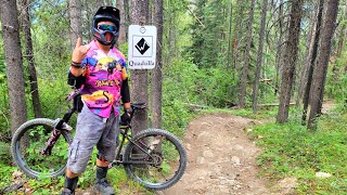
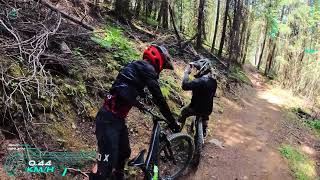
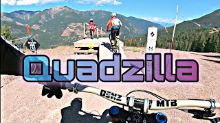
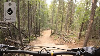
Old school single track at its best. Quadzilla snakes it way to the base through a series of twisting burly berms, rock gardens, bridges, and jumps. It connects to the Canadian Championship DH course on Insanity. Over 20 years old but still running awesome thanks to maintenance and many upgrades over the years. Very technical with multiple rock gardens and rough rooty sections. Bring your big bike and a few extra psi 'cause this one is rugged

Bike Park

More Stats for Quadzilla (Upper) mountain bike trail trail
  • Altitude change
    -466 ft
  • Altitude min
    4,590 ft
  • Altitude max
    5,056 ft
  • Altitude start
    5,056 ft
  • Altitude end
    4,590 ft
  • Grade
    -23.7%
  • Grade max
    -39.8%
  • Grade min
    -4.4%
  • Distance down
    1,936 ft
  • Distance flat
    33 ft
  • Avg time
    00:02:59
  • Avg reverse time
    00:01:57
  • view trail stats
Status:
on Sep 2, 2024
Avg: 4.35 (8 votes)
Your vote: 0

view (1,932)
close
3D
Trail Conditions
  • Unknown
  • Snow Groomed
  • Snow Packed
  • Snow Covered
  • Snow Cover Partial
  • Freeze/thaw Cycle
  • Icy
  • Prevalent Mud
  • Wet
  • Variable
  • Ideal
  • Dry
  • Very Dry
Trail Flow (Ridden Direction)
Trailforks scans users ridelogs to determine the most popular direction each trail is ridden. A good flowing trail network will have most trails flowing in a single direction according to their intension.
The colour categories are based on what percentage of riders are riding a trail in its intended direction.
  • > 96%
  • > 90%
  • > 80%
  • > 70%
  • > 50%
  • < 50%
  • bi-directional trail
  • no data
Trail Last Ridden
Trailforks scans ridelogs to determine the last time a trail was ridden.
  • < 2 days
  • < 1 week
  • < 2 weeks
  • < 1 month
  • < 6 months
  • > 6 months
Trail Ridden Direction
The intended direction a trail should be ridden.
  • Downhill Only
  • Downhill Primary
  • Both Directions
  • Uphill Primary
  • Uphill Only
  • One Direction
Contribute Details
Colors indicate trail is missing specified detail.
  • Description
  • Photos
  • Description & Photos
  • Videos
Trail Popularity ?
Trailforks scans ridelogs to determine which trails are ridden the most in the last 9 months. Trails are compared with nearby trails in the same city region with a possible 25 colour shades. Think of this as a heatmap, more rides = more kinetic energy = warmer colors.
  • most popular
  • popular
  • less popular
  • not popular
ATV/ORV/OHV Filter
Max Vehicle Width
inches
US Cell Coverage
Legend
cell carrier legend

Radar Time
x Activity Recordings
Trailforks users anonymized public ridelogs from the past 6 months.
  • mountain biking recent
  • mountain biking (>6 month)
  • hiking (1 year)
  • moto (1 year)
Activity Recordings
Trailforks users anonymized public skilogs from the past 12 months.
  • Downhill Ski
  • Backcountry Ski
  • Nordic Ski
  • Snowmobile
Winter Trails
Warning A routing network for winter maps does not exist. Selecting trails using the winter trails layer has been disabled.
x Missing Trails
Most Popular
Least Popular
Trails are colored based on popularity. The more popular a trail is, the more red. Less popular trails trend towards green.
Jump Magnitude Heatmap
Heatmap of where riders jump on trails. Zoom in to see individual jumps, click circles to view jump details.
Trails Deemphasized
Trails are shown in grey.
disable
Only show trails with NO bikes.
enable

Save the current map location and zoom level as your default home location whenever this page is loaded.

Save
      Directions to quadzilla-upper trailhead (50.445540, -116.231150)
      update trails status or condition

      Quadzilla (Upper) Trail Reports

      statusdatedescription
      Sep 2, 2024 @ 8:10am
      Sep 2, 2024
      Aug 10, 2024 @ 9:30am
      Aug 10, 2024
      Aug 1, 2024 @ 9:34am
      Aug 1, 2024
      Closed Due to Construction taking place on the ski run 'Old Timer'
      Jul 18, 2024 @ 2:58pm
      Jul 18, 2024
      Sep 18, 2023 @ 8:27am
      Sep 18, 2023
      Closed for the 2023 season
      view all reports »

      Recent Ridelog Activity on Trail

      Past Week
      • 0 rides
      •  
      6 Months
      • 0 rides
      •  
      All
      • 130 rides
      • Last: Aug 23, 2024

      Photos

      more »
      453 |
      Jul 19, 2016 @ 4:06pm
      Jul 19, 2016
      422 |
      Jul 19, 2016 @ 4:39pm
      Jul 19, 2016
      30 |
      Aug 20, 2020 @ 3:50pm
      Aug 20, 2020
      103 |
      Aug 2, 2018 @ 8:33pm
      Aug 2, 2018

      1 Review & Comments


      We hope you've been enjoying Trailforks!

      Create a FREE account to view trail comments and much more.

      Videos

      more »
      Quadzilla / Tadtad ride / Panorama, BC
      6:42 | 82 | Sep 11, 2023 , Invermere
      Panorama Mountain Resort - Quadzilla ◇ Upper...
      10:37 | 94 | Sep 22, 2022 , Invermere
      Quadzilla
      6:48 | 243 | Aug 31, 2021 , Invermere
      Panorama Bike Park - Quadzilla
      6:25 | 312 | Aug 7, 2020 , Invermere
      • By Tekmisfit & contributors
      • #2447 - 3,517 views

      You must enter a description before submitting.