more stats
3,560 ft
Distance
-638 ft
Descent
00:10:45
Avg time
-638 ft
Altitude change
248 ft
Altitude min
886 ft
Altitude max
886 ft
Altitude start
249 ft
Altitude end
-17.9%
Grade
-55.2%
Grade max
3%
Grade min
43 ft
Distance climb
3,241 ft
Distance down
276 ft
Distance flat
00:10:45
Avg time

Rapide Details

  • Activities
    • Mountain Bike
    • E-Bike
    • Hike
    • Trail Running
  • Riding Area
  • Ref Number
    #22
  • Difficulty Rating
  • Voted Difficulty
    Blue (1 vote)
  • Local Popularity
    10 in Mountain Biking [+]
    • 15 in E-Biking
    • 65 in Trail Running
    • 5 in Hiking
  • Global Ranking
    #144493 in Mountain Biking [+]
    • #102474 in E-Biking
    • #90889 in Trail Running
    • #126162 in Hiking
  • Trail Type
    Singletrack
  • Bike Type
    DH, AM
  • Physical Rating
    Moderate
  • Dogs Allowed
    Yes
  • eBike Allowed
    Yes up to Class 1
  • TTFs on Trail
    Roller Coaster, Skinny
  • Land Owner

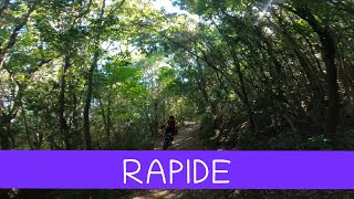
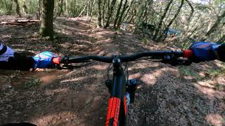
rapide trail is thougth ,the upper part is in a downhill stile ,fast ,dig in , rock ,and root, with a good flow also ,the second part is larger and faster than the first ,and at the last part is steep and sometime in offcamber ,you need a finest braking use, the lastest session in super fast and flowy ,it arrive directly on at the san Quirico Bay ,so wild place
RIDEANDCHILL

Trail Supporters
Local Trail Association

Recent Activity on Trail

Past Week
  • 0 rides
  •  
6 Months
  • 2 rides
  • 17 miles avg distance
All
  • 7 rides
  • Last: May 25, 2026
c1c2c3c4
January
February
March
April
May
June
July
August
September
October
November
December
update trails status or condition

Rapide Trail Reports

statusdatedescription
Jul 27, 2024 @ 12:27am
Jul 27, 2024
non immediato trovare il sentiero nella parte centrale (parzialmemte coperto di fogliame e vegetazione), ma basta un pò di attenzione.
Dec 24, 2023 @ 7:57am
Dec 24, 2023
Poor condition, not fun atm, needs serious rework, description is misleading
Apr 4, 2023 @ 11:33pm
Apr 4, 2023
Could be cleaned
Sep 17, 2022 @ 9:56am
Sep 17, 2022
Sep 17, 2022 @ 9:51am
Sep 17, 2022
more »
Status:
on Jul 27, 2024
Ideal
Avg: 3.68 (7 votes)
Your vote: 0

view (131)
close
3D
Trail Conditions
  • Unknown
  • Snow Groomed
  • Snow Packed
  • Snow Covered
  • Snow Cover Partial
  • Freeze/thaw Cycle
  • Icy
  • Prevalent Mud
  • Wet
  • Variable
  • Ideal
  • Dry
  • Very Dry
Trail Flow (Ridden Direction)
Trailforks scans users ridelogs to determine the most popular direction each trail is ridden. A good flowing trail network will have most trails flowing in a single direction according to their intension.
The colour categories are based on what percentage of riders are riding a trail in its intended direction.
  • > 96%
  • > 90%
  • > 80%
  • > 70%
  • > 50%
  • < 50%
  • bi-directional trail
  • no data
Trail Last Ridden
Trailforks scans ridelogs to determine the last time a trail was ridden.
  • < 2 days
  • < 1 week
  • < 2 weeks
  • < 1 month
  • < 6 months
  • > 6 months
Trail Ridden Direction
The intended direction a trail should be ridden.
  • Downhill Only
  • Downhill Primary
  • Both Directions
  • Uphill Primary
  • Uphill Only
  • One Direction
Contribute Details
Colors indicate trail is missing specified detail.
  • Description
  • Photos
  • Description & Photos
  • Videos
Trail Popularity ?
Trailforks scans ridelogs to determine which trails are ridden the most in the last 9 months. Trails are compared with nearby trails in the same city region with a possible 25 colour shades. Think of this as a heatmap, more rides = more kinetic energy = warmer colors.
  • most popular
  • popular
  • less popular
  • not popular
ATV/ORV/OHV Filter
Max Vehicle Width
inches
US Cell Coverage
Legend
cell carrier legend

Radar Time
Activity Recordings
Trailforks uses anonymized public activity data. ?
Activity Recordings
Trailforks uses anonymized public activity data. ?
Personal Heatmap
Activity Types
all / none
Options
2
Date range month
Winter Trails
Warning A routing network for winter maps does not exist. Selecting trails using the winter trails layer has been disabled.
Missing Trails
Most Popular
Least Popular
Trails are colored based on popularity. The more popular a trail is, the more red. Less popular trails trend towards green.
Jump Magnitude Heatmap
Heatmap of where riders jump on trails. Zoom in to see individual jumps, click circles to view jump details.
BC Backroad Status

Service Road Atlas is a free to use, community-driven service for viewing and creating reports on the numerous back-country service roads around B.C. and Alberta.

map legend
Slope Aspect
Direction the slope faces
Flat N NE E SE S SW W NW
Trails Deemphasized
Trails are shown in grey.
disable
Only show trails with no bike usage.
Enable
Suggested Layers
Based on selected activity type

    Save the current map location and zoom level as your default home location whenever this page is loaded.

    Save
        Directions to rapide trailhead (42.968060, 10.496900)

        Photos

        8 more »
        50 |
        Sep 21, 2023 @ 3:31am
        Sep 21, 2023
        46 |
        Sep 21, 2023 @ 3:31am
        Sep 21, 2023
        184 |
        Jun 12, 2019 @ 6:03am
        Jun 12, 2019
        178 |
        Jun 12, 2019 @ 6:03am
        Jun 12, 2019

        Videos

        3 more »
        youtuber MTB Piombino 11.05.2024 sentiero RAPIDE
        5:08 | 222 | May 12, 2024 , Piombino
        Piombino MTB Trail Area - Rapide - Agosto 2021
        7:18 | 319 | Oct 3, 2021 , Piombino
        Promontorio di Piombino - Rapide parte alta -...
        2:37 | 249 | Sep 8, 2021 , Piombino

        1 Review & Comments


        We hope you've been enjoying Trailforks!

        Create a FREE account to view trail comments and much more.

        • By piombino-mtb-area & contributors
        • #121425 - 1,254 views

        Frequently Asked Questions About Rapide

        Where is Rapide located?
        Rapide is located in Piombino MTB Area, Piombino, Italy. It is part of the Piombino MTB Area trail network. The trailhead is located at coordinates 42.96806, 10.4969.
        How hard is Rapide?
        Rapide is rated as Black difficulty. The physical rating is Moderate. The average grade is 17.9%.
        What is the elevation gain for Rapide?
        The trail has 195 m of elevation descent. The elevation ranges from 76 m to 270 m.
        How long is Rapide?
        Rapide is 1.1 km long. The trail type is singletrack.

        Hit the Trail

        Open in App

        Get this trail on your phone instantly.
        open trail in app

        Download Trail

        Save to wishlist, Garmin & download.
        save the trail

        Find Related Routes

        Find routes and users activities that include this trail.
        find routes for this trail

        You must enter a description before submitting.