more stats
2.5 miles
Distance
405 ft
Climb
-377 ft
Descent
00:35:09
Avg time
28 ft
Altitude change
5,689 ft
Altitude min
6,060 ft
Altitude max
5,689 ft
Altitude start
5,719 ft
Altitude end
0.2%
Grade
-20.8%
Grade max
27.6%
Grade min
5,016 ft
Distance climb
2 miles
Distance down
371 ft
Distance flat
00:35:09
Avg time

Redtail Roost Loop Details

  • Activities
    • Mountain Bike
    • Hike
    • Trail Running
  • Riding Area
  • Ref Number
    #5e17
  • Difficulty Rating
  • Voted Difficulty
    Blue (1 vote)
  • Local Popularity
    45 in Mountain Biking [+]
    • 75 in Trail Running
    • 55 in Hiking
  • Global Ranking
    #115785 in Mountain Biking [+]
    • #86099 in Trail Running
    • #112407 in Hiking
  • Hiking SAC Scale
    T1 Hiking
  • Trail Type
    Singletrack
  • Bike Type
    AM, XC
  • Direction
    Both Directions
    Popular In Reverse
  • Climb Difficulty
    Blue
  • Physical Rating
    Moderate
  • Trail Visibility
    Always easy to follow
  • Dogs Allowed
    Yes
  • eBike Allowed
  • Land Owner

Trail is drawn on map as starting from Escondido Ravine Road, but the description below starts the rider from the southern end of the trail (bottom of the "U") at the parking area.

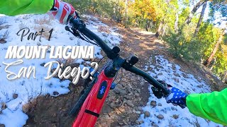
One great link up of BLT trails starts from Red Tail Roost (Laguna Mountain Volunteer Center). From here, ride Red Tail Roost to the left when you exit the parking area. Pedal up an easy climb before a big downhill stretch. The initial part of the descent is open with big swooping turns before dropping into the pines. If you like technical challenges, there are a few sections of log features to test your skills.

The Red Tail Roost section dumps out onto a dirt road. Turn left here and bear left again going up Agua Dulce Creek. The road will climb gradually and eventually funnel into a singletrack. Keep climbing at bit more before a short descent to cross Agua Dulce Creek before pedaling uphill to a intersection.

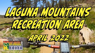
The upper part of Red Tail Roost on BLT to Noble Canyon is open and flowing

Access Info

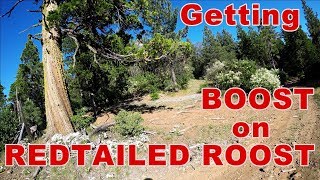
Red Tail Roost Parking Area on Sunrise Highway

Trail Supporters

  • USFS
    Land Manager
Local Trail Association
Traditionally Indigenous Territory

Recent Activity on Trail

Past Week
  • 1 rides
  • 16 miles average
6 Months
  • 26 rides
  • 21 miles avg distance
All
  • 159 rides
  • Last: Jun 28, 2026
c1c2c3c4
January
February
March
April
May
June
July
August
September
October
November
December
update trails status or condition

Redtail Roost Loop Trail Reports

statusdatedescription
Jun 28, 2026 @ 9:11am (America/Los_Angeles)
Jun 28, 2026
May 6, 2026 @ 9:09am (America/Tijuana)
May 6, 2026
loose and rocky but normal for this trail
Mar 14, 2026 @ 8:36am (America/Tijuana)
Mar 14, 2026
loose and rocky but normal for this trail
Jul 5, 2022 @ 10:02am
Jul 5, 2022
reporter
Jun 17, 2022 @ 4:54pm
Jun 17, 2022
reporter Caution Tape Removed
more »
Status:
on Jun 28, 2026
Very Dry
Avg: 3.63 (14 votes)
Your vote: 0

view (756)
close
3D
Trail Conditions
  • Unknown
  • Snow Groomed
  • Snow Packed
  • Snow Covered
  • Snow Cover Partial
  • Freeze/thaw Cycle
  • Icy
  • Prevalent Mud
  • Wet
  • Variable
  • Ideal
  • Dry
  • Very Dry
Trail Flow (Ridden Direction)
Trailforks scans users ridelogs to determine the most popular direction each trail is ridden. A good flowing trail network will have most trails flowing in a single direction according to their intension.
The colour categories are based on what percentage of riders are riding a trail in its intended direction.
  • > 96%
  • > 90%
  • > 80%
  • > 70%
  • > 50%
  • < 50%
  • bi-directional trail
  • no data
Trail Last Ridden
Trailforks scans ridelogs to determine the last time a trail was ridden.
  • < 2 days
  • < 1 week
  • < 2 weeks
  • < 1 month
  • < 6 months
  • > 6 months
Trail Ridden Direction
The intended direction a trail should be ridden.
  • Downhill Only
  • Downhill Primary
  • Both Directions
  • Uphill Primary
  • Uphill Only
  • One Direction
Contribute Details
Colors indicate trail is missing specified detail.
  • Description
  • Photos
  • Description & Photos
  • Videos
Trail Popularity ?
Trailforks scans ridelogs to determine which trails are ridden the most in the last 9 months. Trails are compared with nearby trails in the same city region with a possible 25 colour shades. Think of this as a heatmap, more rides = more kinetic energy = warmer colors.
  • most popular
  • popular
  • less popular
  • not popular
ATV/ORV/OHV Filter
Max Vehicle Width
inches
US Cell Coverage
Legend
cell carrier legend

Radar Time
Activity Recordings
Trailforks uses anonymized public activity data. ?
Activity Recordings
Trailforks uses anonymized public activity data. ?
Personal Heatmap
Activity Types
all / none
Options
2
Date range month
Winter Trails
Warning A routing network for winter maps does not exist. Selecting trails using the winter trails layer has been disabled.
Missing Trails
Most Popular
Least Popular
Trails are colored based on popularity. The more popular a trail is, the more red. Less popular trails trend towards green.
Jump Magnitude Heatmap
Heatmap of where riders jump on trails. Zoom in to see individual jumps, click circles to view jump details.
BC Backroad Status

Service Road Atlas is a free to use, community-driven service for viewing and creating reports on the numerous back-country service roads around B.C. and Alberta.

map legend
Slope Aspect
Direction the slope faces
Flat N NE E SE S SW W NW
Trails Deemphasized
Trails are shown in grey.
disable
Only show trails with no bike usage.
Enable
Suggested Layers
Based on selected activity type

    Save the current map location and zoom level as your default home location whenever this page is loaded.

    Save
        Directions to redtail-roost-loop trailhead (32.871510, -116.439550)

        Photos

        55 more »
        62 |
        Jun 6, 2023 @ 9:13am
        Jun 6, 2023
        62 |
        Jun 6, 2023 @ 9:13am
        Jun 6, 2023
        60 |
        Jun 6, 2023 @ 9:13am
        Jun 6, 2023
        53 |
        Jun 6, 2023 @ 9:13am
        Jun 6, 2023

        Videos

        3 more »
        MTB Mount Laguna San Diego, California...
        20:09 | 97 | Nov 24, 2024 , Mount Laguna
        MTB Playtime in the Laguna Mountains
        10:17 | 266 | Jun 3, 2022 , Mount Laguna
        Getting a Boost on Redtailed Roost DH || 2019...
        5:58 | 236 | Dec 14, 2021 , Mount Laguna

        Routes with this trail

        4.2 18 miles 1,689 ft 14 Loop
        In Bruce Cockburn's wonderful , he sings about wondering where the lions are, which you may wonder...
        4.5 46 miles 6,403 ft 11 Loop
        Leg Day! Don't forget your $5 Parking Pass from the Pine Valley Gas Station. Some Hike-a-bike here and...
        25 miles 2,808 ft 8 Loop
        A good sampling of the major trails on Mt. Laguna proper. It doesn't include Noble, but otherwise it hits...

        2 Reviews & Comments


        We hope you've been enjoying Trailforks!

        Create a FREE account to view trail comments and much more.

        • By stoker1223 & contributors
        • #29304 - 4,931 views

        Frequently Asked Questions About Redtail Roost Loop

        Where is Redtail Roost Loop located?
        Redtail Roost Loop is located in Cleveland National Forest (San Diego County), Mount Laguna, California, United States. It is part of the Cleveland National Forest (San Diego County) trail network. The trailhead is located at coordinates 32.87151, -116.43955.
        How hard is Redtail Roost Loop?
        Redtail Roost Loop is rated as Blue difficulty. The physical rating is Moderate. The average grade is 0.2%. The climb difficulty is rated Blue.
        What is the elevation gain for Redtail Roost Loop?
        Redtail Roost Loop has 405 ft of elevation gain. The trail has 377 ft of elevation descent. The elevation ranges from 5,689 ft to 6,060 ft.
        Is Redtail Roost Loop a point to point trail?
        Redtail Roost Loop is not a point to point trail. The direction is Both Directions. The trail type is singletrack.

        Hit the Trail

        Open in App

        Get this trail on your phone instantly.
        open trail in app

        Download Trail

        Save to wishlist, Garmin & download.
        save the trail

        Find Related Routes

        Find routes and users activities that include this trail.
        find routes for this trail

        You must enter a description before submitting.