
more stats
1.0 mile
Distance
7 ft
Climb
-1,344 ft
Descent
00:18:35
Avg time
-1,338 ft
Altitude change
1,949 ft
Altitude min
3,295 ft
Altitude max
3,295 ft
Altitude start
1,959 ft
Altitude end
-24.5%
Grade
-85.4%
Grade max
8.8%
Grade min
98 ft
Distance climb
1 mile
Distance down
10 ft
Distance flat
00:18:35
Avg time

Rena Trail Details

  • Activities
    • Mountain Bike
    • E-Bike
    • Hike
    • Trail Running
  • Riding Area
  • Difficulty Rating
  • Voted Difficulty
    Black (3 votes)
  • Local Popularity
    80 in Mountain Biking [+]
    • 60 in E-Biking
    • 45 in Trail Running
    • 5 in Hiking
  • Global Ranking
    #128835 in Mountain Biking [+]
    • #102751 in E-Biking
    • #134326 in Trail Running
    • #60415 in Hiking
  • National Ranking
    #9,800 in Mountain Biking · Italy [+]
    • #11,007 in E-Biking
    • #4,336 in Trail Running
    • #1,351 in Hiking
  • Hiking SAC Scale
    T1 Hiking
  • Trail Exposure
    Normal
  • Trail Type
    Singletrack
  • Bike Type
    DH, AM, Fat
  • Direction
    Downhill Only[+]
    Popular Direction Shown
    • Downhill Only for E-Biking
    • Both Directions for Trail Running
    • Both Directions for Hiking
  • Physical Rating
    Hard
  • Season
    Da farsi con terreno asciutto.
  • Dogs Allowed
    Yes
  • eBike Allowed
    Yes up to Class 1
  • TTFs on Trail
    Drop, Jump, Rock Garden

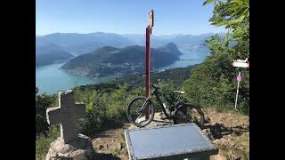
Nuova versione 2026, riveduta e corretta, con partenza più in alto rispetto all'originale.
Discesa molto impegnativa con prima parte parecchio ripida su terreno sabbioso e con passaggi da guidare tra roccette . Seconda parte più veloce con rock garden. Ci sono dei saltini, anche artificiali, da non sottovalutare.
Si esce alle Cave di Saltrio.

Access Info

Dal più basso dei due tornanti sotto alla vetta del Pravello.

Tags
DropsJumpsRock gardens

Recent Activity on Trail

Past Week
  • 0 rides
  •  
6 Months
  • 2 rides
  • 22 miles avg distance
All
  • 18 rides
  • Last: Oct 11, 2026
c1c2c3c4
January
February
March
April
May
June
July
August
September
October
November
December
update trails status or condition

Rena Trail Trail Reports

statusdatedescription
Oct 11, 2026 @ 6:32pm (Europe/Rome)
Oct 11, 2026
Oct 2, 2026 @ 9:26am (Europe/Vaduz)
Oct 2, 2026
Pulitissimo e ben tracciato. Spettacolo
Sep 19, 2026 @ 8:56am (Europe/Vaduz)
Sep 18, 2026
Sentiero in perrfetto stato
Mar 6, 2025 @ 9:02am
Mar 6, 2025
Un ringraziamento a chi ha pulito il trail recentemente (Renato?)! Mai trovato così in ordine, davvero godibile. Grazie!
Aug 17, 2024 @ 3:49am
Aug 17, 2024
Prima parte del trail poco visibile in alcuni punti, bisogna un po' conoscerlo per non finire fuori traccia. Per il resto fondo un po' wild...
more »
Status:
on Oct 11, 2026
Ideal
Avg: 3.91 (6 votes)
Your vote: 0

view (116)
close
      Directions to rena-trail trailhead (45.891890, 8.924540)

      Photos

      No photos have been added for Rena Trail yet, add a photo.

      Videos

      1 more »
      GoPro MAX Mtb:trail Monte Pravello
      mtb
      0:38 | 829 | Aug 19, 2021 , Bisuschio
      3.9 ★★★★★
      6 Ratings
      5 ★ 33%
      4 ★ 33%
      3 ★ 17%
      2 ★ 17%
      1 ★

      10 Reviews & Comments

      suki03 suki03
      Fantastic trail, lots of fun if you like steep and rocky stuff…
      Silo78
      Ripidoni iniziali, misto terra e roccia. Interessante!
      Andre26
      Molto, moooolto migliorabile...
      A tratti sembra buttato lì improvvisato o comunque non lavorato...
      Impegnativo e più tecnico nella prima parte, più veloce e divertente nella seconda.

      We hope you've been enjoying Trailforks!

      Create a FREE account to view all trail reviews and much more.

      • By adessoomaipiuTF Pro & contributors
      • #296808 - 2,560 views

      Frequently Asked Questions

      ▼ Where is Rena Trail located?
      Rena Trail is located in Monte Orsa e Pravello, Bisuschio, Italy. It is part of the Monte Orsa e Pravello trail network. The trailhead is located at coordinates 45.89189, 8.92454.
      ▼ How hard is Rena Trail?
      Rena Trail is rated as Red difficulty. The physical rating is Hard. The average grade is 24.5%.
      ▼ What is the elevation gain for Rena Trail?
      Rena Trail has 7 ft of elevation gain. The trail has 1,344 ft of elevation descent. The elevation ranges from 1,949 ft to 3,295 ft.
      ▼ Is Rena Trail a point to point trail?
      Yes, Rena Trail is a point to point trail. The direction is Downhill Only. The trail type is singletrack.
      ▼ How long is Rena Trail?
      Rena Trail is 1.0 mile long. The trail type is singletrack.
      ▼ Are dogs allowed on Rena Trail?
      Yes, dogs are allowed on Rena Trail. Please keep dogs on a leash where required and clean up after them.
      ▼ When is the best time of year to ride Rena Trail?
      Rena Trail is best visited during: Da farsi con terreno asciutto..
      ▼ How do I access Rena Trail? Where is the closest parking trailhead?
      The closest parking and trailhead locations to Rena Trail are: View all parking locations in the area.
      ▼ How long does it take to ride Rena Trail?
      Based on recorded activities, it takes an average of 19 minutes to ride Rena Trail. The trail is 1.0 mile long. Actual times will vary based on fitness level, conditions, and pace. View recent activity logs for more details.
      ▼ How busy is Rena Trail?
      Rena Trail is a very popular trail. There have been 120 recorded activities on this trail. The trail has received 116 check-ins. View recent activity on this trail.

      Hit the Trail

      Open in App

      Get this trail on your phone instantly.

      open trail in app

      Download Trail

      Save to wishlist, Garmin & download.
      save the trail

      Find Related Routes

      Find routes and users activities that include this trail.
      find routes for this trail

      You must enter a description before submitting.

