more stats
1,129 ft
Distance
-219 ft
Descent
00:00:43
Avg time
-219 ft
Altitude change
5,461 ft
Altitude min
5,680 ft
Altitude max
5,680 ft
Altitude start
5,463 ft
Altitude end
-19.4%
Grade
-46.4%
Grade max
-6.4%
Grade min
1,129 ft
Distance down
00:00:43
Avg time

Repeat Offender Details

  • Activities
    • Mountain Bike
  • Riding Area
    Sun Peaks Bike Park
    Sun Peaks, British Columbia
  • Difficulty Rating
  • Local Popularity
    55 in Mountain Biking
  • Global Ranking
    #92885 in Mountain Biking
  • Trail Type
    Machine Groomed
  • Bike Type
    DH
  • Direction
    Downhill Only
    Popular Direction Shown
  • Dogs Allowed
    Yes
  • Land Owner

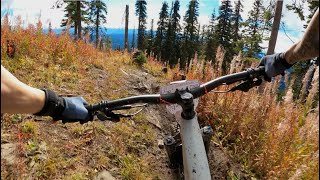
This machine made freeride trail is packed with relatively large doubles and big ol' berms to keep your speed up for hit after hit.

Bike Park

Traditionally Indigenous Territory

Recent Activity on Trail

Past Week
  • 0 rides
  •  
6 Months
  • 1 rides
  • 9 miles avg distance
All
  • 288 rides
  • Last: Dec 24, 2025
c1c2c3c4
January
February
March
April
May
June
July
August
September
October
November
December
update trails status or condition

Repeat Offender Trail Reports

statusdatedescription
Oct 4, 2025 @ 8:15am (America/Vancouver)
Oct 4, 2025
The bike park is now closed for the season, see you all in 2026! :D \m/
Sep 21, 2024 @ 9:26am
Sep 21, 2024
All the lips have been rebuilt as mega dingers, way too steep for how short and quick they are, auto front-flip over the bars jumps. Super sketch.
Jul 7, 2024 @ 3:09am
Jul 7, 2024
Jul 10, 2023 @ 8:18am
Jul 10, 2023
Sep 9, 2022 @ 10:43am
Sep 9, 2022
reporter
more »
Status:
on Oct 4, 2025
Avg: 3.69 (17 votes)
Your vote: 0

view (1,854)
close
3D
Trail Conditions
  • Unknown
  • Snow Groomed
  • Snow Packed
  • Snow Covered
  • Snow Cover Partial
  • Freeze/thaw Cycle
  • Icy
  • Prevalent Mud
  • Wet
  • Variable
  • Ideal
  • Dry
  • Very Dry
Trail Flow (Ridden Direction)
Trailforks scans users ridelogs to determine the most popular direction each trail is ridden. A good flowing trail network will have most trails flowing in a single direction according to their intension.
The colour categories are based on what percentage of riders are riding a trail in its intended direction.
  • > 96%
  • > 90%
  • > 80%
  • > 70%
  • > 50%
  • < 50%
  • bi-directional trail
  • no data
Trail Last Ridden
Trailforks scans ridelogs to determine the last time a trail was ridden.
  • < 2 days
  • < 1 week
  • < 2 weeks
  • < 1 month
  • < 6 months
  • > 6 months
Trail Ridden Direction
The intended direction a trail should be ridden.
  • Downhill Only
  • Downhill Primary
  • Both Directions
  • Uphill Primary
  • Uphill Only
  • One Direction
Contribute Details
Colors indicate trail is missing specified detail.
  • Description
  • Photos
  • Description & Photos
  • Videos
Trail Popularity ?
Trailforks scans ridelogs to determine which trails are ridden the most in the last 9 months. Trails are compared with nearby trails in the same city region with a possible 25 colour shades. Think of this as a heatmap, more rides = more kinetic energy = warmer colors.
  • most popular
  • popular
  • less popular
  • not popular
ATV/ORV/OHV Filter
Max Vehicle Width
inches
US Cell Coverage
Legend
cell carrier legend

Radar Time
Activity Recordings
Trailforks uses anonymized public activity data. ?
Activity Recordings
Trailforks uses anonymized public activity data. ?
Personal Heatmap
Activity Types
all / none
Options
2
Date range month
Winter Trails
Warning A routing network for winter maps does not exist. Selecting trails using the winter trails layer has been disabled.
Missing Trails
Most Popular
Least Popular
Trails are colored based on popularity. The more popular a trail is, the more red. Less popular trails trend towards green.
Jump Magnitude Heatmap
Heatmap of where riders jump on trails. Zoom in to see individual jumps, click circles to view jump details.
BC Backroad Status

Service Road Atlas is a free to use, community-driven service for viewing and creating reports on the numerous back-country service roads around B.C. and Alberta.

map legend
Slope Aspect
Direction the slope faces
Flat N NE E SE S SW W NW
Trails Deemphasized
Trails are shown in grey.
disable
Only show trails with no bike usage.
Enable
Suggested Layers
Based on selected activity type

    Save the current map location and zoom level as your default home location whenever this page is loaded.

    Save
        Directions to repeat-offender trailhead (50.894650, -119.905690)

        Photos

        2 more »
        65 |
        Jul 25, 2019 @ 3:45pm
        Jul 25, 2019
        54 |
        Feb 12, 2024 @ 8:23am
        Feb 12, 2024

        Videos

        2 more »
        Stage 3 | SUN PEAKS BIKEPARK Canadian Enduro...
        7:37 | 68 | Nov 28, 2023 , Sun Peaks
        Sun Peaks Bike Park - Repeat Offender [Aug 2013]
        663 | Sep 14, 2016 , Sun Peaks

        Routes with this trail

        71 miles 29,933 ft 37
        An attempt at riding every trail in Sun Peaks over a weekend.
        3.4 29 miles 10,162 ft 18 Race

        1 Review & Comments


        We hope you've been enjoying Trailforks!

        Create a FREE account to view trail comments and much more.

        Frequently Asked Questions About Repeat Offender

        Where is Repeat Offender located?
        Repeat Offender is located in Sun Peaks Bike Park, Sun Peaks, British Columbia, Canada. It is part of the Sun Peaks Bike Park trail network. The trailhead is located at coordinates 50.89465, -119.90569.
        How hard is Repeat Offender?
        Repeat Offender is rated as Black Diamond difficulty. The average grade is 19.4%.
        What is the elevation gain for Repeat Offender?
        The trail has 219 ft of elevation descent. The elevation ranges from 5,461 ft to 5,680 ft.
        Is Repeat Offender a point to point trail?
        Yes, Repeat Offender is a point to point trail. The direction is Downhill Only. The trail type is machine groomed.

        Hit the Trail

        Open in App

        Get this trail on your phone instantly.
        open trail in app

        Download Trail

        Save to wishlist, Garmin & download.
        save the trail

        Find Related Routes

        Find routes and users activities that include this trail.
        find routes for this trail

        You must enter a description before submitting.