more stats
1,352 ft
Distance
10 ft
Climb
-88 ft
Descent
00:02:42
Avg time
-77 ft
Altitude change
1,981 ft
Altitude min
2,062 ft
Altitude max
2,059 ft
Altitude start
1,982 ft
Altitude end
-5.7%
Grade
-28.5%
Grade max
6.3%
Grade min
325 ft
Distance climb
866 ft
Distance down
161 ft
Distance flat
00:02:42
Avg time

Rift, upper Details

  • Activities
    • Mountain Bike
    • E-Bike
    • Hike
    • Trail Running
  • Riding Area
    Predator Ridge
    Vernon, British Columbia
  • Difficulty Rating
  • Local Popularity
    95 in Mountain Biking [+]
    • 95 in E-Biking
    • 70 in Trail Running
    • 85 in Hiking
  • Global Ranking
    #7126 in Mountain Biking [+]
    • #15448 in E-Biking
    • #86075 in Trail Running
    • #54657 in Hiking
  • Trail Type
    Singletrack
  • Bike Type
    AM
  • Direction
    Downhill Primary
    Popular Direction Shown
  • Trail Visibility
    Always easy to follow
  • Dogs Allowed
    Yes
  • eBike Allowed
  • TTFs on Trail
    Drop, Rock Face, Rock Garden
  • Year Opened
    2023
  • Land Owner
    Predator Ridge Resort

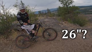
This is the start of the Rift, also the connector to Rock Garden Play ground A trail in it's own rights, with short rock slabs, gravity feeds and optional drops and tec rock features.

Access Info

comes off the corner of Salamander Slabs and Granite

Recent Activity on Trail

Past Week
  • 13 rides
  • 12 miles average
6 Months
  • 265 rides
  • 11 miles avg distance
All
  • 1,012 rides
  • Last: Jun 26, 2026
c1c2c3c4
January
February
March
April
May
June
July
August
September
October
November
December
update trails status or condition

Rift, upper Trail Reports

statusdatedescription
May 27, 2026 @ 1:39pm (America/Creston)
May 27, 2026
Apr 26, 2026 @ 8:42am (America/Creston)
Apr 26, 2026
Apr 2, 2026 @ 10:57am (America/Creston)
Apr 2, 2026
Nov 4, 2025 @ 5:39am (America/Vancouver)
Nov 4, 2025
reporter Predator Ridge closes their mountain bike trails every fall in preparation for the freeze-thaw cycle. This is for two reasons: preservation of the...
Oct 30, 2025 @ 3:36pm (America/Vancouver)
Oct 30, 2025
more »
Status:
on May 27, 2026
Ideal
Avg: 3.99 (2 votes)
Your vote: 0

view (4,459)
close
3D
Trail Conditions
  • Unknown
  • Snow Groomed
  • Snow Packed
  • Snow Covered
  • Snow Cover Partial
  • Freeze/thaw Cycle
  • Icy
  • Prevalent Mud
  • Wet
  • Variable
  • Ideal
  • Dry
  • Very Dry
Trail Flow (Ridden Direction)
Trailforks scans users ridelogs to determine the most popular direction each trail is ridden. A good flowing trail network will have most trails flowing in a single direction according to their intension.
The colour categories are based on what percentage of riders are riding a trail in its intended direction.
  • > 96%
  • > 90%
  • > 80%
  • > 70%
  • > 50%
  • < 50%
  • bi-directional trail
  • no data
Trail Last Ridden
Trailforks scans ridelogs to determine the last time a trail was ridden.
  • < 2 days
  • < 1 week
  • < 2 weeks
  • < 1 month
  • < 6 months
  • > 6 months
Trail Ridden Direction
The intended direction a trail should be ridden.
  • Downhill Only
  • Downhill Primary
  • Both Directions
  • Uphill Primary
  • Uphill Only
  • One Direction
Contribute Details
Colors indicate trail is missing specified detail.
  • Description
  • Photos
  • Description & Photos
  • Videos
Trail Popularity ?
Trailforks scans ridelogs to determine which trails are ridden the most in the last 9 months. Trails are compared with nearby trails in the same city region with a possible 25 colour shades. Think of this as a heatmap, more rides = more kinetic energy = warmer colors.
  • most popular
  • popular
  • less popular
  • not popular
ATV/ORV/OHV Filter
Max Vehicle Width
inches
US Cell Coverage
Legend
cell carrier legend

Radar Time
Activity Recordings
Trailforks uses anonymized public activity data. ?
Activity Recordings
Trailforks uses anonymized public activity data. ?
Personal Heatmap
Activity Types
all / none
Options
2
Date range month
Winter Trails
Warning A routing network for winter maps does not exist. Selecting trails using the winter trails layer has been disabled.
Missing Trails
Most Popular
Least Popular
Trails are colored based on popularity. The more popular a trail is, the more red. Less popular trails trend towards green.
Jump Magnitude Heatmap
Heatmap of where riders jump on trails. Zoom in to see individual jumps, click circles to view jump details.
BC Backroad Status

Service Road Atlas is a free to use, community-driven service for viewing and creating reports on the numerous back-country service roads around B.C. and Alberta.

map legend
Slope Aspect
Direction the slope faces
Flat N NE E SE S SW W NW
Trails Deemphasized
Trails are shown in grey.
disable
Only show trails with no bike usage.
Enable
Suggested Layers
Based on selected activity type

    Save the current map location and zoom level as your default home location whenever this page is loaded.

    Save
        Directions to rift-upper trailhead (50.190900, -119.408430)

        Photos

        No photos have been added for Rift, upper yet, add a photo.

        Videos

        1 more »
        Is A 26' Tire Enduro Bike Still Rideable? - A...
        10:35 | 163 | Jul 22, 2023 , Vernon

        Routes with this trail

        9 miles 1,534 ft 14
        This is the NOCS Fiver Downcountry route for the advanced level. Lots of ups and downs on this ride....
        9 miles 1,730 ft 12
        NOCS 2023 Social Ride #3 brought to you by Olympia ski and cycle and McElhhanney. With the new parking lot...
        7 miles 1,358 ft 14
        The first Social Ride of 2023 is brought to you by Predator Ridge! The new trails are up and ready for you...

        Reviews / Comments

        No reviews yet, be the first to write a review or ask a question.
        Use trail reports to comment on trail conditions.


        We hope you've been enjoying Trailforks!

        Create a FREE account to view trail comments and much more.

        • By roanzTF Pro NOCS & contributors
        • #630769 - 627 views

        Frequently Asked Questions About Rift, upper

        Where is Rift, upper located?
        Rift, upper is located in Predator Ridge, Vernon, British Columbia, Canada. It is part of the Predator Ridge trail network. The trailhead is located at coordinates 50.1909, -119.40843.
        How hard is Rift, upper?
        Rift, upper is rated as Blue difficulty. The average grade is 5.7%.
        What is the elevation gain for Rift, upper?
        Rift, upper has 10 ft of elevation gain. The trail has 88 ft of elevation descent. The elevation ranges from 1,981 ft to 2,062 ft.
        Is Rift, upper a point to point trail?
        Rift, upper is not a point to point trail. The direction is Downhill Primary. The trail type is singletrack.

        Hit the Trail

        Open in App

        Get this trail on your phone instantly.
        open trail in app

        Download Trail

        Save to wishlist, Garmin & download.
        save the trail

        Find Related Routes

        Find routes and users activities that include this trail.
        find routes for this trail

        You must enter a description before submitting.