This trail is archived
This trail is permanently closed/decommissioned
more stats
384 ft
Distance
-36 ft
Descent
00:00:12
Avg time
-38 ft
Altitude change
166 ft
Altitude min
203 ft
Altitude max
203 ft
Altitude start
167 ft
Altitude end
-9.8%
Grade
-20.4%
Grade max
344 ft
Distance down
39 ft
Distance flat
00:00:12
Avg time

River Gap Details

  • Activities
    • Mountain Bike
  • Riding Area
    Skarpa Toruń
    Toruń
  • AKA
    Road Gap
  • Difficulty Rating
  • Local Popularity
    5 in Mountain Biking
  • Blaze Color
  • Trail Type
    Singletrack
  • Bike Type
    DH, DJ
  • Direction
    Downhill Only
  • Physical Rating
    Easy
  • Season
    mar-oct
  • Dogs Allowed
    Yes
  • TTFs on Trail
    Berm, Jump, Gap Jump
  • Year Opened
    2016

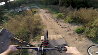
Uwaga - tymczasowo oficjalnie trasa kończy się przed drogą. Osoby chcące skakać Road Gap i River Gap prosimy o zorganizowanie obstawy skrzyżowania przed przejazdem, tak by nie wpaść na auto lub pieszego.

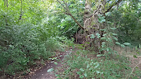
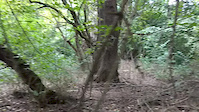
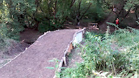
O trasie: znana jest też jako "Road Gap". Właściwa trasa zaczyna się po hopie do lasu (HP2) - celuj w bandę w lewo. Ścieżka z kilkoma bandami poprowadzi do hopy przez drogę (Road Gap), następnie hopę przez strumień (River Gap). Jadąc prosto za moment będziesz przy Wiśle Smile można wrócić na górę albo w lewo szukając metalowego mostka, albo w prawo dłuższą dróżką zakręcającą na północ.

This trail is unsanctioned.

Recent Activity on Trail

Past Week
  • 0 rides
  •  
6 Months
  • 0 rides
  •  
All
  • 9 rides
  • Last: May 27, 2025
c1c2c3c4
January
February
March
April
May
June
July
August
September
October
November
December
update trails status or condition

River Gap Trail Reports

statusdatedescription
Mar 14, 2024 @ 2:15pm
Mar 14, 2024
Oct 4, 2020 @ 4:57am
Oct 4, 2020
Mokro. Do drogi ok, hopka przez strumyk zniszczona.
Aug 2, 2020 @ 7:58am
Aug 2, 2020
Wszystko działa. Sucho jak pieprz, da się nawet wrócić suchą stopą przez strumyk.
May 11, 2020 @ 11:04am
May 11, 2020
River gap uszkodzony, nie skakać.
Apr 14, 2019 @ 12:22pm
Apr 14, 2019
Jest dobrze, gdzieniegdzie piach ale czysto i ładnie
more »
Status:
on Mar 14, 2024
Avg: 4.13 (1 votes)
Your vote: 0

view (214)
close
3D
Trail Conditions
  • Unknown
  • Snow Groomed
  • Snow Packed
  • Snow Covered
  • Snow Cover Partial
  • Freeze/thaw Cycle
  • Icy
  • Prevalent Mud
  • Wet
  • Variable
  • Ideal
  • Dry
  • Very Dry
Trail Flow (Ridden Direction)
Trailforks scans users ridelogs to determine the most popular direction each trail is ridden. A good flowing trail network will have most trails flowing in a single direction according to their intension.
The colour categories are based on what percentage of riders are riding a trail in its intended direction.
  • > 96%
  • > 90%
  • > 80%
  • > 70%
  • > 50%
  • < 50%
  • bi-directional trail
  • no data
Trail Last Ridden
Trailforks scans ridelogs to determine the last time a trail was ridden.
  • < 2 days
  • < 1 week
  • < 2 weeks
  • < 1 month
  • < 6 months
  • > 6 months
Trail Ridden Direction
The intended direction a trail should be ridden.
  • Downhill Only
  • Downhill Primary
  • Both Directions
  • Uphill Primary
  • Uphill Only
  • One Direction
Contribute Details
Colors indicate trail is missing specified detail.
  • Description
  • Photos
  • Description & Photos
  • Videos
Trail Popularity ?
Trailforks scans ridelogs to determine which trails are ridden the most in the last 9 months. Trails are compared with nearby trails in the same city region with a possible 25 colour shades. Think of this as a heatmap, more rides = more kinetic energy = warmer colors.
  • most popular
  • popular
  • less popular
  • not popular
ATV/ORV/OHV Filter
Max Vehicle Width
inches
US Cell Coverage
Legend
cell carrier legend

Radar Time
Activity Recordings
Trailforks uses anonymized public activity data. ?
Activity Recordings
Trailforks uses anonymized public activity data. ?
Personal Heatmap
Activity Types
all / none
Options
2
Date range month
Winter Trails
Warning A routing network for winter maps does not exist. Selecting trails using the winter trails layer has been disabled.
Missing Trails
Most Popular
Least Popular
Trails are colored based on popularity. The more popular a trail is, the more red. Less popular trails trend towards green.
Jump Magnitude Heatmap
Heatmap of where riders jump on trails. Zoom in to see individual jumps, click circles to view jump details.
BC Backroad Status

Service Road Atlas is a free to use, community-driven service for viewing and creating reports on the numerous back-country service roads around B.C. and Alberta.

map legend
Slope Aspect
Direction the slope faces
Flat N NE E SE S SW W NW
Trails Deemphasized
Trails are shown in grey.
disable
Only show trails with no bike usage.
Enable
Suggested Layers
Based on selected activity type

    Save the current map location and zoom level as your default home location whenever this page is loaded.

    Save
        Directions to river-gap trailhead (53.017580, 18.668930)

        Photos

        3 more »
        156 |
        May 30, 2019 @ 12:34pm
        May 30, 2019
        154 |
        May 30, 2019 @ 12:35pm
        May 30, 2019
        120 |
        Aug 14, 2018 @ 12:25pm
        Aug 14, 2018

        Videos

        17 more »
        Super fast jump #1 still not cleared
        0:09 | 230 | Aug 5, 2018 , Toruń
        Super fast jump #2 cleared
        0:05 | 175 | Aug 5, 2018 , Toruń
        River Gap upgrade - test
        0:05 | 212 | Aug 3, 2018 , Toruń
        RIVER GAP
        0:47 | 183 | Oct 1, 2017 , Toruń

        Reviews / Comments

        No reviews yet, be the first to write a review or ask a question.
        Use trail reports to comment on trail conditions.


        We hope you've been enjoying Trailforks!

        Create a FREE account to view trail comments and much more.

        • #85976 - 1,697 views

        Hit the Trail

        Open in App

        Get this trail on your phone instantly.
        open trail in app

        Download Trail

        Save to wishlist, Garmin & download.
        save the trail

        Find Related Routes

        Find routes and users activities that include this trail.
        find routes for this trail

        You must enter a description before submitting.