more stats
1,129 ft
Distance
-193 ft
Descent
1,418 ft
High Point
-193 ft
Altitude change
1,225 ft
Altitude min
1,418 ft
Altitude start
1,227 ft
Altitude end
-17.1%
Grade
-42.5%
Grade max
-2.1%
Grade min
1,129 ft
Distance down

Roca Real Details

  • Activities
    • Mountain Bike
    • E-Bike
    • Hike
    • Trail Running
  • Riding Area
    La Plana Alta
    Vilanova D'Alcolea
  • Difficulty Rating
  • Local Popularity
    90 in Mountain Biking [+]
    • 95 in E-Biking
    • 5 in Trail Running
    • 5 in Hiking
  • Global Ranking
    #6781 in Mountain Biking [+]
    • #18238 in E-Biking
    • #161020 in Trail Running
    • #157781 in Hiking
  • Trail Type
    Singletrack
  • Bike Type
    AM, XC
  • Direction
    Downhill Primary
    Popular Direction Shown
  • Climb Difficulty
    Black Diamond
  • Physical Rating
    Moderate
  • Trail Visibility
    Sometimes hard to follow
  • Dogs Allowed
    Yes
  • eBike Allowed
    Yes up to Class 1

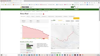
Sendero de bajada con muchos toboganes entre pinos. Algunos con escalones verticales. El agua se ha llevado mucha tierra,y ha dejado rocas a la vista.

Local Trail Association

Recent Activity on Trail

Past Week
  • 1 rides
  • 9 miles average
6 Months
  • 3 rides
  • 13 miles avg distance
All
  • 35 rides
  • Last: Jul 1, 2026
c1c2c3c4
January
February
March
April
May
June
July
August
September
October
November
December
update trails status or condition

Roca Real Trail Reports

Status:
on Jul 1, 2026
Dry
Avg: 4.13 (1 votes)
Your vote: 0

view (117)
close
3D
Trail Conditions
  • Unknown
  • Snow Groomed
  • Snow Packed
  • Snow Covered
  • Snow Cover Partial
  • Freeze/thaw Cycle
  • Icy
  • Prevalent Mud
  • Wet
  • Variable
  • Ideal
  • Dry
  • Very Dry
Trail Flow (Ridden Direction)
Trailforks scans users ridelogs to determine the most popular direction each trail is ridden. A good flowing trail network will have most trails flowing in a single direction according to their intension.
The colour categories are based on what percentage of riders are riding a trail in its intended direction.
  • > 96%
  • > 90%
  • > 80%
  • > 70%
  • > 50%
  • < 50%
  • bi-directional trail
  • no data
Trail Last Ridden
Trailforks scans ridelogs to determine the last time a trail was ridden.
  • < 2 days
  • < 1 week
  • < 2 weeks
  • < 1 month
  • < 6 months
  • > 6 months
Trail Ridden Direction
The intended direction a trail should be ridden.
  • Downhill Only
  • Downhill Primary
  • Both Directions
  • Uphill Primary
  • Uphill Only
  • One Direction
Contribute Details
Colors indicate trail is missing specified detail.
  • Description
  • Photos
  • Description & Photos
  • Videos
Trail Popularity ?
Trailforks scans ridelogs to determine which trails are ridden the most in the last 9 months. Trails are compared with nearby trails in the same city region with a possible 25 colour shades. Think of this as a heatmap, more rides = more kinetic energy = warmer colors.
  • most popular
  • popular
  • less popular
  • not popular
ATV/ORV/OHV Filter
Max Vehicle Width
inches
US Cell Coverage
Legend
cell carrier legend

Radar Time
Activity Recordings
Trailforks uses anonymized public activity data. ?
Activity Recordings
Trailforks uses anonymized public activity data. ?
Personal Heatmap
Activity Types
all / none
Options
2
Date range month
Winter Trails
Warning A routing network for winter maps does not exist. Selecting trails using the winter trails layer has been disabled.
Missing Trails
Most Popular
Least Popular
Trails are colored based on popularity. The more popular a trail is, the more red. Less popular trails trend towards green.
Jump Magnitude Heatmap
Heatmap of where riders jump on trails. Zoom in to see individual jumps, click circles to view jump details.
BC Backroad Status

Service Road Atlas is a free to use, community-driven service for viewing and creating reports on the numerous back-country service roads around B.C. and Alberta.

map legend
Slope Aspect
Direction the slope faces
Flat N NE E SE S SW W NW
Trails Deemphasized
Trails are shown in grey.
disable
Only show trails with no bike usage.
Enable
Suggested Layers
Based on selected activity type

    Save the current map location and zoom level as your default home location whenever this page is loaded.

    Save
        Directions to roca-real trailhead (40.259410, 0.043510)

        Photos

        2 more »
        40 |
        Jul 14, 2024 @ 6:42am
        Jul 14, 2024
        24 |
        Jul 14, 2024 @ 6:42am
        Jul 14, 2024

        Videos

        6 more »
        Roca Real 4k vilanova
        0:45 | 33 | Apr 27, 2025 , Vilanova D'Alcolea
        ROCA REAL4K vilanova
        0:53 | 22 | Apr 11, 2025 , Vilanova D'Alcolea
        Roca Real
        0:54 | 36 | Mar 28, 2025 , Vilanova D'Alcolea
        Roca Real
        2:21 | 85 | May 28, 2024 , Vilanova D'Alcolea

        Routes with this trail

        36 miles 5,256 ft 40 Out & Back
        La Ruta El Tour dels Tobogans es una ruta que comienza en Coves de Vinroma se divide en 3 etapas en las...
        11 miles 1,714 ft 14 Loop
        Ruta corta pero muy exigente. Incluye la senda que se puede hacer en las dos direcciones, en este caso de...

        1 Review & Comments


        We hope you've been enjoying Trailforks!

        Create a FREE account to view trail comments and much more.

        • By architrepaTF Pro TFSPAIN & contributors
        • #748038 - 646 views

        Frequently Asked Questions About Roca Real

        Where is Roca Real located?
        Roca Real is located in La Plana Alta, Vilanova D'Alcolea, Spain. It is part of the La Plana Alta trail network. The trailhead is located at coordinates 40.25941, 0.04351.
        How hard is Roca Real?
        Roca Real is rated as Red difficulty. The physical rating is Moderate. The average grade is 17.1%. The climb difficulty is rated Black Diamond.
        What is the elevation gain for Roca Real?
        The trail has 193 ft of elevation descent. The elevation ranges from 1,225 ft to 1,418 ft.
        Is Roca Real a point to point trail?
        Roca Real is not a point to point trail. The direction is Downhill Primary. The trail type is singletrack.

        Hit the Trail

        Open in App

        Get this trail on your phone instantly.
        open trail in app

        Download Trail

        Save to wishlist, Garmin & download.
        save the trail

        Find Related Routes

        Find routes and users activities that include this trail.
        find routes for this trail

        You must enter a description before submitting.