more stats
4,406 ft
Distance
-1,048 ft
Descent
00:11:14
Avg time
-1,048 ft
Altitude change
5,767 ft
Altitude min
6,815 ft
Altitude max
6,815 ft
Altitude start
5,768 ft
Altitude end
-23.8%
Grade
-64.5%
Grade max
-4%
Grade min
4,406 ft
Distance down
00:11:14
Avg time

Rocket Science Details

  • Activities
    • Mountain Bike
  • Riding Area
    Big White Bike Park
    Kelowna, British Columbia
  • AKA
    Enduro Stage 3
  • Difficulty Rating
  • Local Popularity
    40 in Mountain Biking
  • Global Ranking
    #123270 in Mountain Biking
  • Trail Type
    Singletrack
  • Bike Type
    DH
  • Direction
    Downhill Only
    Popular Direction Shown
  • TTFs on Trail
    Drop, Jump, Rock Face, Rock Garden
  • Year Opened
    2017
  • Land Owner
    Big White Ski Resort Ltd

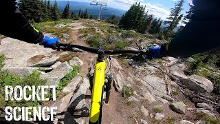
Long with loose, steep sections and rock faces. a few lines to choose on the way down. Lots of "no spill" zones.

Naming Story: It is a technical trail. It is under the Ridge Rocket... You don't need to be a rocket scientist to figure it out ;o)
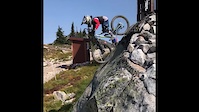
Access Info

Off Bumble Bee

Bike Park

Recent Activity on Trail

Past Week
  • 0 rides
  •  
6 Months
  • 5 rides
  • 24 miles avg distance
All
  • 112 rides
  • Last: Mar 25, 2026
c1c2c3c4
January
February
March
April
May
June
July
August
September
October
November
December
update trails status or condition

Rocket Science Trail Reports

statusdatedescription
Jul 1, 2026 @ 6:09pm (America/Vancouver)
2 days
Open for the 2026 bike season!
Apr 30, 2026 @ 2:34pm (America/Vancouver)
Apr 30, 2026
Opening Day - July 1st 2026. See you soon
Jun 27, 2025 @ 9:49am
Jun 27, 2025
Open for the 2025 Bike Park Season! We're open Thursday to Sunday and holiday Mondays. Please respect closures.
Sep 3, 2024 @ 12:10pm
Sep 3, 2024
Closed for 2024... See you back on the trails in 2025!
Aug 15, 2024 @ 6:28pm
Aug 15, 2024
the redeeming trail at Big White. mmm mmm good riding!
more »
Status:
on Jul 1, 2026
Ideal
Avg: 3.72 (12 votes)
Your vote: 0

view (636)
close
3D
Trail Conditions
  • Unknown
  • Snow Groomed
  • Snow Packed
  • Snow Covered
  • Snow Cover Partial
  • Freeze/thaw Cycle
  • Icy
  • Prevalent Mud
  • Wet
  • Variable
  • Ideal
  • Dry
  • Very Dry
Trail Flow (Ridden Direction)
Trailforks scans users ridelogs to determine the most popular direction each trail is ridden. A good flowing trail network will have most trails flowing in a single direction according to their intension.
The colour categories are based on what percentage of riders are riding a trail in its intended direction.
  • > 96%
  • > 90%
  • > 80%
  • > 70%
  • > 50%
  • < 50%
  • bi-directional trail
  • no data
Trail Last Ridden
Trailforks scans ridelogs to determine the last time a trail was ridden.
  • < 2 days
  • < 1 week
  • < 2 weeks
  • < 1 month
  • < 6 months
  • > 6 months
Trail Ridden Direction
The intended direction a trail should be ridden.
  • Downhill Only
  • Downhill Primary
  • Both Directions
  • Uphill Primary
  • Uphill Only
  • One Direction
Contribute Details
Colors indicate trail is missing specified detail.
  • Description
  • Photos
  • Description & Photos
  • Videos
Trail Popularity ?
Trailforks scans ridelogs to determine which trails are ridden the most in the last 9 months. Trails are compared with nearby trails in the same city region with a possible 25 colour shades. Think of this as a heatmap, more rides = more kinetic energy = warmer colors.
  • most popular
  • popular
  • less popular
  • not popular
ATV/ORV/OHV Filter
Max Vehicle Width
inches
US Cell Coverage
Legend
cell carrier legend

Radar Time
Activity Recordings
Trailforks uses anonymized public activity data. ?
Activity Recordings
Trailforks uses anonymized public activity data. ?
Personal Heatmap
Activity Types
all / none
Options
2
Date range month
Winter Trails
Warning A routing network for winter maps does not exist. Selecting trails using the winter trails layer has been disabled.
Missing Trails
Most Popular
Least Popular
Trails are colored based on popularity. The more popular a trail is, the more red. Less popular trails trend towards green.
Jump Magnitude Heatmap
Heatmap of where riders jump on trails. Zoom in to see individual jumps, click circles to view jump details.
BC Backroad Status

Service Road Atlas is a free to use, community-driven service for viewing and creating reports on the numerous back-country service roads around B.C. and Alberta.

map legend
Slope Aspect
Direction the slope faces
Flat N NE E SE S SW W NW
Trails Deemphasized
Trails are shown in grey.
disable
Only show trails with no bike usage.
Enable
Suggested Layers
Based on selected activity type

    Save the current map location and zoom level as your default home location whenever this page is loaded.

    Save
        Directions to rocket-science trailhead (49.730650, -118.937260)

        Photos

        24 more »
        85 |
        Jul 9, 2024 @ 8:22am
        Jul 9, 2024
        81 |
        Jul 9, 2024 @ 8:22am
        Jul 9, 2024
        86 |
        Jul 9, 2024 @ 8:21am
        Jul 9, 2024
        192 |
        Jan 22, 2021 @ 12:16am
        Jan 22, 2021

        Videos

        2 more »
        Rocket Science (Uncut First Attempt)
        5:11 | 755 | Nov 15, 2020 , Kelowna
        Cohen Johns (10) & Rex Johnson (10) Ride Big White
        0:56 | 157 | Sep 21, 2020 , Kelowna

        Routes with this trail

        19 miles 8,125 ft 46 Loop Race
        (ALL CATEGORIES- NEED TO ASSESS WHEN TIMING STARTS AND STOPS IN RELATION TO CONNECTING STAGES) ATHLETE...

        5 Reviews & Comments


        We hope you've been enjoying Trailforks!

        Create a FREE account to view trail comments and much more.

        • By plimdaddyTF Pro BWTC & contributors
        • #136993 - 4,102 views

        Frequently Asked Questions About Rocket Science

        Where is Rocket Science located?
        Rocket Science is located in Big White Bike Park, Kelowna, British Columbia, Canada. It is part of the Big White Bike Park trail network. The trailhead is located at coordinates 49.73065, -118.93726.
        How hard is Rocket Science?
        Rocket Science is rated as Double Black Diamond difficulty. The average grade is 23.8%.
        What is the elevation gain for Rocket Science?
        The trail has 1,048 ft of elevation descent. The elevation ranges from 5,767 ft to 6,815 ft.
        Is Rocket Science a point to point trail?
        Yes, Rocket Science is a point to point trail. The direction is Downhill Only. The trail type is singletrack.

        Hit the Trail

        Open in App

        Get this trail on your phone instantly.
        open trail in app

        Download Trail

        Save to wishlist, Garmin & download.
        save the trail

        Find Related Routes

        Find routes and users activities that include this trail.
        find routes for this trail

        You must enter a description before submitting.