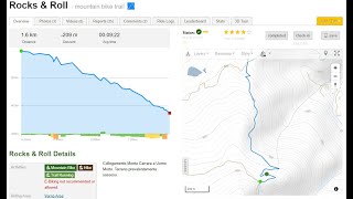
more stats
5,246 ft
Distance
-687 ft
Descent
00:10:56
Avg time
-687 ft
Altitude change
1,263 ft
Altitude min
1,950 ft
Altitude max
1,950 ft
Altitude start
1,263 ft
Altitude end
-13.1%
Grade
-44.9%
Grade max
-0.5%
Grade min
5,220 ft
Distance down
26 ft
Distance flat
00:10:56
Avg time

Rocks & Roll Details

  • Activities
    • Mountain Bike
    • E-Bike
    • Hike
    • Trail Running
  • Riding Area
  • Difficulty Rating
  • Voted Difficulty
    White (1 vote)
  • Local Popularity
    50 in Mountain Biking [+]
    • 5 in E-Biking
    • 5 in Trail Running
    • 5 in Hiking
  • Global Ranking
    #130534 in Mountain Biking [+]
    • #213426 in E-Biking
    • #303372 in Trail Running
    • #296382 in Hiking
  • National Ranking
    #9,908 in Mountain Biking · Italy [+]
    • #19,485 in E-Biking
    • #10,328 in Trail Running
    • #10,366 in Hiking
  • Hiking SAC Scale
    T1 Hiking
  • Trail Type
    Singletrack
  • Bike Type
    DH, AM
  • Direction
    Downhill Primary
    Popular Direction Shown
  • Climb Difficulty
    Blue
  • Physical Rating
    Moderate
  • Trail Visibility
    Always easy to follow
  • Dogs Allowed
    Yes
  • eBike Allowed
    Yes up to Class 1
  • TTFs on Trail
    Rock Garden

Collegamento Monte Carrara a Uomo Morto. Terreno prevalentemente sassoso.

Tags
Rock gardens

Local Trail Association

Recent Activity on Trail

Past Week
  • 0 rides
  •  
6 Months
  • 1 rides
  • 12 miles avg distance
All
  • 56 rides
  • Last: Oct 17, 2026
c1c2c3c4
January
February
March
April
May
June
July
August
September
October
November
December
update trails status or condition

Rocks & Roll Trail Reports

statusdatedescription
Oct 5, 2026 @ 8:51pm (Europe/Rome)
Oct 5, 2026
reporter
Mar 23, 2026 @ 7:46pm (Europe/Rome)
Mar 23, 2026
reporter
Dec 10, 2025 @ 5:22pm (Europe/Rome)
Dec 10, 2025
vegetazione incolta, molto molto scavato e con la vegetazione che restringe le possibilità di traiettorie diventa difficile, e pericoloso quando...
Oct 14, 2025 @ 11:51am (Europe/Rome)
Oct 14, 2025
zu viele pflanzen....zugewachsen mit stachel Gestrüpp....schmerz:-(...trail ansich sehr interessant könnte richtig spaß machen.
May 16, 2025 @ 1:53am
May 16, 2025
vegetazione incolta, si sta chiudendo, un vero peccato.
more »
Status:
on Oct 5, 2026
Very Dry
Avg: 3.82 (6 votes)
Your vote: 0

view (237)
close
      Directions to rocks--roll trailhead (43.769510, 10.500590)

      Photos

      4 more »
      mtb
      77 |
      Jan 21, 2023 @ 12:05pm
      Jan 21, 2023
      mtb
      192 |
      Feb 23, 2021 @ 11:32am
      Feb 23, 2021
      mtb
      192 |
      Feb 23, 2021 @ 11:31am
      Feb 23, 2021
      mtb
      182 |
      Feb 23, 2021 @ 11:31am
      Feb 23, 2021

      Videos

      1 more »
      rocks&roll
      ebike
      8:49 | 301 | May 15, 2022 , Lucca

      Routes with this trail

      ★ 3.8 • 20 miles • 3,094 ft • 10 • Out & Back •
      Percorso con partenza da Lucca, salita attraverso le colline di Vorno, passaggio a Santallago fino alla...
      3.7 ★★★★★
      6 Ratings
      5 ★ 17%
      4 ★ 33%
      3 ★ 50%
      2 ★
      1 ★

      3 Reviews & Comments

      domebasse
      Evitare con fondo bagnato, presenza costante di rocce scivolose e canali
      Orazio80
      Non si può considerare un trail ma semplicemente una strada parecchio scassata e rocciosa...
      Colore verde a mio avviso...
      davidemalibu
      Trail impegnativo e molto scassato, fare attenzione ai vari canali che si sono formati durante le piogge.
      P.s. Occhio ai sassi appuntiti

      We hope you've been enjoying Trailforks!

      Create a FREE account to view all trail reviews and much more.

      Frequently Asked Questions

      ▼ Where is Rocks & Roll located?
      Rocks & Roll is located in Vorno Trail Area, Lucca, Italy. It is part of the Vorno Trail Area trail network. The trailhead is located at coordinates 43.76951, 10.50059.
      ▼ How hard is Rocks & Roll?
      Rocks & Roll is rated as Black difficulty. The physical rating is Moderate. The average grade is 13.1%. The climb difficulty is rated Blue.
      ▼ What is the elevation gain for Rocks & Roll?
      The trail has 687 ft of elevation descent. The elevation ranges from 1,263 ft to 1,950 ft.
      ▼ Is Rocks & Roll a point to point trail?
      Rocks & Roll is not a point to point trail. The direction is Downhill Primary. The trail type is singletrack.
      ▼ How long is Rocks & Roll?
      Rocks & Roll is 5,246 ft long. The trail type is singletrack.
      ▼ Are dogs allowed on Rocks & Roll?
      Yes, dogs are allowed on Rocks & Roll. Please keep dogs on a leash where required and clean up after them.
      ▼ How do I access Rocks & Roll? Where is the closest parking trailhead?
      The closest parking and trailhead locations to Rocks & Roll are: View all parking locations in the area.
      ▼ How long does it take to ride Rocks & Roll?
      Based on recorded activities, it takes an average of 11 minutes to ride Rocks & Roll. The trail is 5,246 ft long. Actual times will vary based on fitness level, conditions, and pace. View recent activity logs for more details.
      ▼ How busy is Rocks & Roll?
      Rocks & Roll is a moderately popular trail. There have been 251 recorded activities on this trail. The trail has received 237 check-ins. View recent activity on this trail.

      Hit the Trail

      Open in App

      Get this trail on your phone instantly.

      open trail in app

      Download Trail

      Save to wishlist, Garmin & download.
      save the trail

      Find Related Routes

      Find routes and users activities that include this trail.
      find routes for this trail

      You must enter a description before submitting.