
more stats
1.2 miles
Distance
-1,597 ft
Descent
00:10:23
Avg time
-1,597 ft
Altitude change
1,542 ft
Altitude min
3,139 ft
Altitude max
3,139 ft
Altitude start
1,542 ft
Altitude end
-25.9%
Grade
-78%
Grade max
-3.8%
Grade min
1 mile
Distance down
00:10:23
Avg time

Rollercoston Details

  • Activities
    • Mountain Bike
    • E-Bike
    • Hike
    • Trail Running
  • Riding Area
  • Difficulty Rating
  • Local Popularity
    75 in Mountain Biking [+]
    • 80 in E-Biking
    • 5 in Trail Running
    • 5 in Hiking
  • Global Ranking
    #5183 in Mountain Biking [+]
    • #95318 in E-Biking
    • #406666 in Trail Running
    • #407481 in Hiking
  • National Ranking
    #539 in Mountain Biking · Italy [+]
    • #10,577 in E-Biking
    • #17,220 in Trail Running
    • #17,189 in Hiking
  • Hiking SAC Scale
    T2 Mountain Hiking
  • Trail Type
    Singletrack
  • Bike Type
    DH, AM
  • Direction
    Downhill Primary
    Popular Direction Shown
  • Trail Visibility
    Always easy to follow
  • eBike Allowed
    Yes up to Class 1

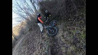
Dalla Madonna del Costone i più maniconi possono scendere dalla vertical S3+; mentre per chi non se la sente, seguire la traccia ritornando in parte sui propri passi e deviando su un bel S1/S2. Arrivati al bivio a quota 950m ci aspettano 100m di un bel croccante e scenico S3- per poi diventare un bellissimo guidato nel bosco S1 con qualche passaggio S2.

In alternativa verso la fine a quota 550m, la traccia devia a ovest su un bel S3, per chi non se la sente deviare a nord.

La parte alta della discesa è molto drenante, la seconda metà invece se umida dalle piggie diventa una saponetta.

Tags

Recent Activity on Trail

Past Week
  • 0 rides
  •  
6 Months
  • 0 rides
  •  
All
  • 1 rides
  • Last: Aug 1, 2026
update trails status or condition

Rollercoston Trail Reports

statusdatedescription
Jan 29, 2024 @ 12:00am
Jan 29, 2024
https://youtu.be/q25mrIwRzfU?si=Fk4wQ-ay3N3gCoCa
Jan 28, 2024 @ 2:22pm
Jan 28, 2024
Sentiero pulito, la parte finale è leggermente ghiacciata, ma si scende abbastanza bene
more »
Status:
on Jan 29, 2024
Dry
Avg: 4.24 (2 votes)
Your vote: 0

view (44)
close
      Directions to rollercoston trailhead (45.777760, 9.708670)

      Photos

      5 more »
      mtb
      54 |
      Feb 24, 2024 @ 12:31pm
      Feb 24, 2024
      mtb
      49 |
      Feb 24, 2024 @ 12:30pm
      Feb 24, 2024
      mtb
      41 |
      Jan 21, 2024 @ 11:06pm
      Jan 21, 2024
      mtb
      40 |
      Jan 21, 2024 @ 11:05pm
      Jan 21, 2024

      Videos

      1 more »
      Super DH del Costone (Rollercoston)- Poscante...
      mtb
      20:41 | 97 | Jan 29, 2024 , My City
      5.0 ★★★★★
      2 Ratings
      5 ★ 100%
      4 ★
      3 ★
      2 ★
      1 ★

      Reviews / Comments

      No reviews yet, be the first to write a review or ask a question.
      Use trail reports to comment on trail conditions.


      We hope you've been enjoying Trailforks!

      Create a FREE account to view all trail reviews and much more.

      • By orobictrails-valebgTF Pro & contributors
      • #723085 - 479 views

      Frequently Asked Questions

      ▼ Where is Rollercoston located?
      Rollercoston is located in Ganda - Selvino, Italy. It is part of the Ganda - Selvino trail network. The trailhead is located at coordinates 45.77776, 9.70867.
      ▼ How hard is Rollercoston?
      Rollercoston is rated as Blue difficulty. The average grade is 25.9%.
      ▼ What is the elevation gain for Rollercoston?
      The trail has 1,597 ft of elevation descent. The elevation ranges from 1,542 ft to 3,139 ft.
      ▼ Is Rollercoston a point to point trail?
      Rollercoston is not a point to point trail. The direction is Downhill Primary. The trail type is singletrack.
      ▼ How long is Rollercoston?
      Rollercoston is 1.2 miles long. The trail type is singletrack.
      ▼ Are dogs allowed on Rollercoston?
      There is no information about dogs being allowed on Rollercoston. Check with local trail managers or the trail page for the latest access rules.
      ▼ How do I access Rollercoston? Where is the closest parking trailhead?
      The closest parking and trailhead locations to Rollercoston are: View all parking locations in the area.
      ▼ How long does it take to ride Rollercoston?
      Based on recorded activities, it takes an average of 10 minutes to ride Rollercoston. The trail is 1.2 miles long. Actual times will vary based on fitness level, conditions, and pace. View recent activity logs for more details.
      ▼ How busy is Rollercoston?
      Rollercoston is a very popular trail. There have been 44 recorded activities on this trail. The trail has received 44 check-ins. View recent activity on this trail.

      Hit the Trail

      Open in App

      Get this trail on your phone instantly.

      open trail in app

      Download Trail

      Save to wishlist, Garmin & download.
      save the trail

      Find Related Routes

      Find routes and users activities that include this trail.
      find routes for this trail

      You must enter a description before submitting.

