more stats
1.1 miles
Distance
-1,452 ft
Descent
00:07:02
Avg time
-1,453 ft
Altitude change
1,658 ft
Altitude min
3,112 ft
Altitude max
3,112 ft
Altitude start
1,657 ft
Altitude end
-25.9%
Grade
-96.1%
Grade max
-7.6%
Grade min
1 mile
Distance down
00:07:02
Avg time

Rolling Coal Details

  • Activities
    • Mountain Bike
  • Riding Area
    Windrock Bike Park
    Oliver Springs, Tennessee
  • AKA
    Unsustainable
  • Difficulty Rating
  • Voted Difficulty
    Black Diamond (1 vote)
  • Local Popularity
    15 in Mountain Biking
  • Global Ranking
    #14082 in Mountain Biking
  • Trail Type
    Singletrack
  • Bike Type
    DH, AM
  • Direction
    Downhill Only
    Popular Direction Shown
  • Trail Visibility
    Always easy to follow
  • TTFs on Trail
    Berm, Drop, Rock Garden
  • Year Opened
    2018
  • Land Owner
    sean_leader

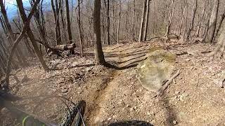
Steep and off camber.
Natural "Rake and Ride" style Downhill/Enduro track.
No machines were used in the making of this trail.
Entirely hand worked.
Created and opened Winter 2018.
Built by: Sean Leader, and William Wright.
\m/

Trail Supporters

  • Sean Leader

    since 2018
    Builder
  • William Wright
    since 2018
    Builder

Bike Park

Recent Activity on Trail

Past Week
  • 0 rides
  •  
6 Months
  • 0 rides
  •  
All
  • 7 rides
  • Last: Aug 10, 2025
c1c2c3c4
January
February
March
April
May
June
July
August
September
October
November
December
update trails status or condition

Rolling Coal Trail Reports

statusdatedescription
Nov 5, 2020 @ 11:38am
Nov 5, 2020
Lots of leaves hiding the terrain and a few downed trees.
Mar 7, 2020 @ 10:13am
Mar 7, 2020
Mar 6, 2020 @ 11:47am
Mar 6, 2020
more »
Status:
on Nov 5, 2020
Dry
Avg: 4.45 (5 votes)
Your vote: 0

view (252)
close
3D
Trail Conditions
  • Unknown
  • Snow Groomed
  • Snow Packed
  • Snow Covered
  • Snow Cover Partial
  • Freeze/thaw Cycle
  • Icy
  • Prevalent Mud
  • Wet
  • Variable
  • Ideal
  • Dry
  • Very Dry
Trail Flow (Ridden Direction)
Trailforks scans users ridelogs to determine the most popular direction each trail is ridden. A good flowing trail network will have most trails flowing in a single direction according to their intension.
The colour categories are based on what percentage of riders are riding a trail in its intended direction.
  • > 96%
  • > 90%
  • > 80%
  • > 70%
  • > 50%
  • < 50%
  • bi-directional trail
  • no data
Trail Last Ridden
Trailforks scans ridelogs to determine the last time a trail was ridden.
  • < 2 days
  • < 1 week
  • < 2 weeks
  • < 1 month
  • < 6 months
  • > 6 months
Trail Ridden Direction
The intended direction a trail should be ridden.
  • Downhill Only
  • Downhill Primary
  • Both Directions
  • Uphill Primary
  • Uphill Only
  • One Direction
Contribute Details
Colors indicate trail is missing specified detail.
  • Description
  • Photos
  • Description & Photos
  • Videos
Trail Popularity ?
Trailforks scans ridelogs to determine which trails are ridden the most in the last 9 months. Trails are compared with nearby trails in the same city region with a possible 25 colour shades. Think of this as a heatmap, more rides = more kinetic energy = warmer colors.
  • most popular
  • popular
  • less popular
  • not popular
ATV/ORV/OHV Filter
Max Vehicle Width
inches
US Cell Coverage
Legend
cell carrier legend

Radar Time
Activity Recordings
Trailforks uses anonymized public activity data. ?
Activity Recordings
Trailforks uses anonymized public activity data. ?
Personal Heatmap
Activity Types
all / none
Options
2
Date range month
Winter Trails
Warning A routing network for winter maps does not exist. Selecting trails using the winter trails layer has been disabled.
Missing Trails
Most Popular
Least Popular
Trails are colored based on popularity. The more popular a trail is, the more red. Less popular trails trend towards green.
Jump Magnitude Heatmap
Heatmap of where riders jump on trails. Zoom in to see individual jumps, click circles to view jump details.
BC Backroad Status

Service Road Atlas is a free to use, community-driven service for viewing and creating reports on the numerous back-country service roads around B.C. and Alberta.

map legend
Slope Aspect
Direction the slope faces
Flat N NE E SE S SW W NW
Trails Deemphasized
Trails are shown in grey.
disable
Only show trails with no bike usage.
Enable
Suggested Layers
Based on selected activity type

    Save the current map location and zoom level as your default home location whenever this page is loaded.

    Save
        Directions to rolling-coal trailhead (36.103780, -84.335850)

        Photos

        5 more »
        68 |
        Apr 8, 2025 @ 5:03pm
        Apr 8, 2025
        67 |
        Apr 8, 2025 @ 5:02pm
        Apr 8, 2025
        144 |
        Oct 25, 2021 @ 5:07pm
        Oct 25, 2021
        223 |
        Feb 22, 2021 @ 7:40pm
        Feb 22, 2021

        Videos

        3 more »
        Rolling Coal (Unsustainable) - Windrock, TN...
        3:34 | 1005 | Aug 11, 2020 , Oliver Springs
        Oops!
        0:07 | 151 | Jun 9, 2023 , Oliver Springs
        Opps
        0:07 | | Jun 3, 2023 , Oliver Springs

        Reviews / Comments

        No reviews yet, be the first to write a review or ask a question.
        Use trail reports to comment on trail conditions.


        We hope you've been enjoying Trailforks!

        Create a FREE account to view trail comments and much more.

        • By kyleluvsdhTF Pro & contributors
        • #242615 - 1,888 views

        Frequently Asked Questions About Rolling Coal

        Where is Rolling Coal located?
        Rolling Coal is located in Windrock Bike Park, Oliver Springs, Tennessee, United States. It is part of the Windrock Bike Park trail network. The trailhead is located at coordinates 36.10378, -84.33585.
        How hard is Rolling Coal?
        Rolling Coal is rated as Double Black Diamond difficulty. The average grade is 25.9%.
        What is the elevation gain for Rolling Coal?
        The trail has 1,452 ft of elevation descent. The elevation ranges from 1,658 ft to 3,112 ft.
        Is Rolling Coal a point to point trail?
        Yes, Rolling Coal is a point to point trail. The direction is Downhill Only. The trail type is singletrack.

        Hit the Trail

        Open in App

        Get this trail on your phone instantly.
        open trail in app

        Download Trail

        Save to wishlist, Garmin & download.
        save the trail

        Find Related Routes

        Find routes and users activities that include this trail.
        find routes for this trail

        You must enter a description before submitting.