more stats
3,169 ft
Distance
43 ft
Climb
-42 ft
Descent
00:04:37
Avg time
0 ft
Altitude change
5 ft
Altitude min
21 ft
Altitude max
14 ft
Altitude start
14 ft
Altitude end
0.01%
Grade
-8.559%
Grade max
7.595%
Grade min
1,143 ft
Distance climb
1,064 ft
Distance down
897 ft
Distance flat
00:04:37
Avg time

Root Loop Details

  • Activities
    • Mountain Bike
  • Riding Area
    Camp Murphy
    Hobe Sound, Florida
  • Difficulty Rating
  • Local Popularity
    60 in Mountain Biking
  • Global Ranking
    #101156 in Mountain Biking
  • Trail Type
    Singletrack
  • Bike Type
    AM, XC
  • Direction
    One Direction
  • Dogs Allowed
    Yes
  • eBike Allowed
  • TTFs on Trail
    Drop, Ladder Bridge, Other

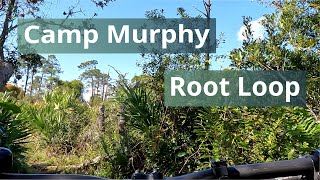
The outermost loop, yet unburned but half-exposed and so it still has a natural surface but some sandy portions. Also, as the name implies, it has sections with a lot of palmetto roots for some grueling xc tech challenge.

Local Trail Association
Traditionally Indigenous Territory

Recent Activity on Trail

Past Week
  • 0 rides
  •  
6 Months
  • 54 rides
  • 10 miles avg distance
All
  • 493 rides
  • Last: Jun 7, 2026
c1c2c3c4
January
February
March
April
May
June
July
August
September
October
November
December
Status:
on May 30, 2026
Variable
Avg: 3.99 (2 votes)
Your vote: 0

view (7,245)
close
3D
Trail Conditions
  • Unknown
  • Snow Groomed
  • Snow Packed
  • Snow Covered
  • Snow Cover Partial
  • Freeze/thaw Cycle
  • Icy
  • Prevalent Mud
  • Wet
  • Variable
  • Ideal
  • Dry
  • Very Dry
Trail Flow (Ridden Direction)
Trailforks scans users ridelogs to determine the most popular direction each trail is ridden. A good flowing trail network will have most trails flowing in a single direction according to their intension.
The colour categories are based on what percentage of riders are riding a trail in its intended direction.
  • > 96%
  • > 90%
  • > 80%
  • > 70%
  • > 50%
  • < 50%
  • bi-directional trail
  • no data
Trail Last Ridden
Trailforks scans ridelogs to determine the last time a trail was ridden.
  • < 2 days
  • < 1 week
  • < 2 weeks
  • < 1 month
  • < 6 months
  • > 6 months
Trail Ridden Direction
The intended direction a trail should be ridden.
  • Downhill Only
  • Downhill Primary
  • Both Directions
  • Uphill Primary
  • Uphill Only
  • One Direction
Contribute Details
Colors indicate trail is missing specified detail.
  • Description
  • Photos
  • Description & Photos
  • Videos
Trail Popularity ?
Trailforks scans ridelogs to determine which trails are ridden the most in the last 9 months. Trails are compared with nearby trails in the same city region with a possible 25 colour shades. Think of this as a heatmap, more rides = more kinetic energy = warmer colors.
  • most popular
  • popular
  • less popular
  • not popular
ATV/ORV/OHV Filter
Max Vehicle Width
inches
US Cell Coverage
Legend
cell carrier legend

Radar Time
Activity Recordings
Trailforks uses anonymized public activity data. ?
Activity Recordings
Trailforks uses anonymized public activity data. ?
Personal Heatmap
Activity Types
all / none
Options
2
Date range month
Winter Trails
Warning A routing network for winter maps does not exist. Selecting trails using the winter trails layer has been disabled.
Missing Trails
Most Popular
Least Popular
Trails are colored based on popularity. The more popular a trail is, the more red. Less popular trails trend towards green.
Jump Magnitude Heatmap
Heatmap of where riders jump on trails. Zoom in to see individual jumps, click circles to view jump details.
BC Backroad Status

Service Road Atlas is a free to use, community-driven service for viewing and creating reports on the numerous back-country service roads around B.C. and Alberta.

map legend
Slope Aspect
Direction the slope faces
Flat N NE E SE S SW W NW
Trails Deemphasized
Trails are shown in grey.
disable
Only show trails with no bike usage.
Enable
Suggested Layers
Based on selected activity type

    Save the current map location and zoom level as your default home location whenever this page is loaded.

    Save
        Directions to root-loop trailhead (26.992235, -80.103001)

        Photos

        3 more »
        15 |
        May 17, 2026 @ 6:05pm
        May 17, 2026
        61 |
        Oct 22, 2025 @ 10:15am
        Oct 22, 2025
        442 |
        Jun 10, 2012 @ 4:34am
        Jun 10, 2012
        23 |
        May 17, 2026 @ 6:05pm
        May 17, 2026

        Videos

        1 more »
        Root Loop Trail, Camp Murphy, Jonathan...
        5:43 | 28 | Oct 7, 2025 , Hobe Sound

        Reviews / Comments

        No reviews yet, be the first to write a review or ask a question.
        Use trail reports to comment on trail conditions.


        We hope you've been enjoying Trailforks!

        Create a FREE account to view trail comments and much more.

        Frequently Asked Questions About Root Loop

        Where is Root Loop located?
        Root Loop is located in Camp Murphy, Hobe Sound, Florida, United States. It is part of the Camp Murphy trail network. The trailhead is located at coordinates 26.99224, -80.103.
        How hard is Root Loop?
        Root Loop is rated as Blue difficulty. The average grade is 0.01%.
        What is the elevation gain for Root Loop?
        Root Loop has 43 ft of elevation gain. The trail has 42 ft of elevation descent. The elevation ranges from 5 ft to 21 ft.
        Is Root Loop a point to point trail?
        Yes, Root Loop is a point to point trail. The direction is One Direction. The trail type is singletrack.

        Hit the Trail

        Open in App

        Get this trail on your phone instantly.
        open trail in app

        Download Trail

        Save to wishlist, Garmin & download.
        save the trail

        Find Related Routes

        Find routes and users activities that include this trail.
        find routes for this trail

        You must enter a description before submitting.