more stats
2,244 ft
Distance
-109 ft
Descent
00:05:08
Avg time
-109 ft
Altitude change
80 ft
Altitude min
189 ft
Altitude max
189 ft
Altitude start
79 ft
Altitude end
-4.9%
Grade
-26.9%
Grade max
2.4%
Grade min
69 ft
Distance climb
1,998 ft
Distance down
115 ft
Distance flat
00:05:08
Avg time

Rooty McRootersen Details

  • Activities
    • Mountain Bike
    • Hike
    • Trail Running
  • Riding Area
    Kincaid Park
    Anchorage, Alaska
  • Difficulty Rating
  • Local Popularity
    60 in Mountain Biking [+]
    • 50 in Trail Running
    • 35 in Hiking
  • Global Ranking
    #53674 in Mountain Biking [+]
    • #39055 in Hiking
  • Trail Type
    Singletrack
  • Bike Type
    AM, XC
  • Direction
    Both Directions
  • Climb Difficulty
    Black Diamond
  • Physical Rating
    Moderate
  • Season
    MAY - OCT
  • Dogs Allowed
    Yes
  • TTFs on Trail
    Other

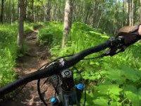
Rooty trail that is a fun downhill run out to Beer Can Lake. From the Bottom of the trail you can either take the ski trail back up to middle earth. Or take the road out to Raspberry Rd and across to the start of Tower Power.

Access Info

Bike out either Old School from the west side (closer to second breakfast) or up from the bottom of Candy Mountain. This will be a trail that dives off to the right hand side from the climb up Candy mountain.

Local Trail Association
Traditionally Indigenous Territory

Recent Activity on Trail

Past Week
  • 1 rides
  • 9 miles average
6 Months
  • 2 rides
  • 15 miles avg distance
All
  • 49 rides
  • Last: Jun 4, 2026
c1c2c3c4
January
February
March
April
May
June
July
August
September
October
November
December
update trails status or condition

Rooty McRootersen Trail Reports

statusdatedescription
Sep 11, 2023 @ 7:18am
Sep 11, 2023
Down tree
May 29, 2023 @ 10:43pm
May 29, 2023
A few Downes logs across trail
May 29, 2022 @ 11:34am
May 29, 2022
Apr 28, 2022 @ 6:40pm
Apr 28, 2022
Mar 26, 2021 @ 5:22pm
Mar 26, 2021
No recent traffic, old tracks, deep snow, narrow.
more »
Status:
on Sep 11, 2023
Prevalent Mud
Avg: 3.98 (1 votes)
Your vote: 0

view (419)
close
3D
Trail Conditions
  • Unknown
  • Snow Groomed
  • Snow Packed
  • Snow Covered
  • Snow Cover Partial
  • Freeze/thaw Cycle
  • Icy
  • Prevalent Mud
  • Wet
  • Variable
  • Ideal
  • Dry
  • Very Dry
Trail Flow (Ridden Direction)
Trailforks scans users ridelogs to determine the most popular direction each trail is ridden. A good flowing trail network will have most trails flowing in a single direction according to their intension.
The colour categories are based on what percentage of riders are riding a trail in its intended direction.
  • > 96%
  • > 90%
  • > 80%
  • > 70%
  • > 50%
  • < 50%
  • bi-directional trail
  • no data
Trail Last Ridden
Trailforks scans ridelogs to determine the last time a trail was ridden.
  • < 2 days
  • < 1 week
  • < 2 weeks
  • < 1 month
  • < 6 months
  • > 6 months
Trail Ridden Direction
The intended direction a trail should be ridden.
  • Downhill Only
  • Downhill Primary
  • Both Directions
  • Uphill Primary
  • Uphill Only
  • One Direction
Contribute Details
Colors indicate trail is missing specified detail.
  • Description
  • Photos
  • Description & Photos
  • Videos
Trail Popularity ?
Trailforks scans ridelogs to determine which trails are ridden the most in the last 9 months. Trails are compared with nearby trails in the same city region with a possible 25 colour shades. Think of this as a heatmap, more rides = more kinetic energy = warmer colors.
  • most popular
  • popular
  • less popular
  • not popular
ATV/ORV/OHV Filter
Max Vehicle Width
inches
US Cell Coverage
Legend
cell carrier legend

Radar Time
Activity Recordings
Trailforks uses anonymized public activity data. ?
Activity Recordings
Trailforks uses anonymized public activity data. ?
Personal Heatmap
Activity Types
all / none
Options
2
Date range month
Winter Trails
Warning A routing network for winter maps does not exist. Selecting trails using the winter trails layer has been disabled.
Missing Trails
Most Popular
Least Popular
Trails are colored based on popularity. The more popular a trail is, the more red. Less popular trails trend towards green.
Jump Magnitude Heatmap
Heatmap of where riders jump on trails. Zoom in to see individual jumps, click circles to view jump details.
BC Backroad Status

Service Road Atlas is a free to use, community-driven service for viewing and creating reports on the numerous back-country service roads around B.C. and Alberta.

map legend
Slope Aspect
Direction the slope faces
Flat N NE E SE S SW W NW
Trails Deemphasized
Trails are shown in grey.
disable
Only show trails with no bike usage.
Enable
Suggested Layers
Based on selected activity type

    Save the current map location and zoom level as your default home location whenever this page is loaded.

    Save
        Directions to rooty-mcrootersen trailhead (61.159090, -150.027800)

        Photos

        2 more »
        83 |
        Apr 19, 2023 @ 10:19am
        Apr 19, 2023
        50 |
        May 29, 2022 @ 12:09pm
        May 29, 2022

        Videos

        1 more »
        Kincaid Park - 'Rooty McRootersen'
        55 | Jun 22, 2025 , Anchorage

        Trail Lists

        Routes with this trail

        36 miles 3,253 ft 23 Loop
        COURSE DESCRIPTION Racers should always follow the flags to their right. There are multiple areas where...
        20 miles 1,745 ft 13 Loop Race
        2021 ABC XCM Course 7/31/2021

        Reviews / Comments

        No reviews yet, be the first to write a review or ask a question.
        Use trail reports to comment on trail conditions.


        We hope you've been enjoying Trailforks!

        Create a FREE account to view trail comments and much more.

        Frequently Asked Questions About Rooty McRootersen

        Where is Rooty McRootersen located?
        Rooty McRootersen is located in Kincaid Park, Anchorage, Alaska, United States. It is part of the Kincaid Park trail network. The trailhead is located at coordinates 61.15909, -150.0278.
        How hard is Rooty McRootersen?
        Rooty McRootersen is rated as Black Diamond difficulty. The physical rating is Moderate. The average grade is 4.9%. The climb difficulty is rated Black Diamond.
        What is the elevation gain for Rooty McRootersen?
        The trail has 109 ft of elevation descent. The elevation ranges from 80 ft to 189 ft.
        Is Rooty McRootersen a point to point trail?
        Rooty McRootersen is not a point to point trail. The direction is Both Directions. The trail type is singletrack.

        Hit the Trail

        Open in App

        Get this trail on your phone instantly.
        open trail in app

        Download Trail

        Save to wishlist, Garmin & download.
        save the trail

        Find Related Routes

        Find routes and users activities that include this trail.
        find routes for this trail

        You must enter a description before submitting.