more stats
3,153 ft
Distance
-234 ft
Descent
1,672 ft
High Point
-235 ft
Altitude change
1,437 ft
Altitude min
1,672 ft
Altitude start
1,437 ft
Altitude end
-7.5%
Grade
-26.7%
Grade max
4.4%
Grade min
105 ft
Distance climb
2,749 ft
Distance down
299 ft
Distance flat

Rumble Bee Details

  • Activities
    • Mountain Bike
  • Riding Area
    Mt. Telemark Village
    Cable, Wisconsin
  • Difficulty Rating
  • Local Popularity
    85 in Mountain Biking
  • Global Ranking
    #14206 in Mountain Biking
  • Trail Type
    Singletrack
  • Direction
    Downhill Only
    Popular Direction Shown
  • Dogs Allowed
    Yes
  • TTFs on Trail
    Berm, Drop, Jump, Rock Garden
  • Land Owner

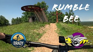
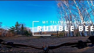
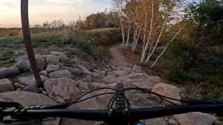
The rowdy sidekick to Jumptimus Prime, Rumble Bee has a little bit of everything to try. We classify it as technical downhill trail, with jumps, drops, rock gradens, roots, and off-camber sections intermixed with smoother, machine built flow and berms. All features are rollable, but become a whole new challenge when you try the trail faster.

Local Trail Association

Recent Activity on Trail

Past Week
  • 5 rides
  • 12 miles average
6 Months
  • 10 rides
  • 14 miles avg distance
All
  • 60 rides
  • Last: Jun 7, 2026
c1c2c3c4
January
February
March
April
May
June
July
August
September
October
November
December
update trails status or condition

Rumble Bee Trail Reports

statusdatedescription
May 21, 2026 @ 9:25am (America/Chicago)
May 21, 2026
Conditions remain great out here, with some residual moisture left in the soil and great riding temps. Next week will be warming up so expect...
May 1, 2026 @ 5:47pm (America/Chicago)
May 1, 2026
May 1, 2026 @ 5:45pm (America/Chicago)
May 1, 2026
Apr 2, 2026 @ 9:19am (America/Chicago)
Apr 2, 2026
Trails will remain closed for some time until the final few winter storms and the spring freeze/thaw cycle end. As things dry out, we will begin...
Nov 11, 2025 @ 11:07am (America/Chicago)
Nov 11, 2025
As we get into a freeze/thaw cycle, we ask that you keep off trails until we can assess the conditon they will be in after this last period of...
more »
Status:
on May 21, 2026
Dry
Avg: 4.13 (1 votes)
Your vote: 0

view (374)
close
3D
Trail Conditions
  • Unknown
  • Snow Groomed
  • Snow Packed
  • Snow Covered
  • Snow Cover Partial
  • Freeze/thaw Cycle
  • Icy
  • Prevalent Mud
  • Wet
  • Variable
  • Ideal
  • Dry
  • Very Dry
Trail Flow (Ridden Direction)
Trailforks scans users ridelogs to determine the most popular direction each trail is ridden. A good flowing trail network will have most trails flowing in a single direction according to their intension.
The colour categories are based on what percentage of riders are riding a trail in its intended direction.
  • > 96%
  • > 90%
  • > 80%
  • > 70%
  • > 50%
  • < 50%
  • bi-directional trail
  • no data
Trail Last Ridden
Trailforks scans ridelogs to determine the last time a trail was ridden.
  • < 2 days
  • < 1 week
  • < 2 weeks
  • < 1 month
  • < 6 months
  • > 6 months
Trail Ridden Direction
The intended direction a trail should be ridden.
  • Downhill Only
  • Downhill Primary
  • Both Directions
  • Uphill Primary
  • Uphill Only
  • One Direction
Contribute Details
Colors indicate trail is missing specified detail.
  • Description
  • Photos
  • Description & Photos
  • Videos
Trail Popularity ?
Trailforks scans ridelogs to determine which trails are ridden the most in the last 9 months. Trails are compared with nearby trails in the same city region with a possible 25 colour shades. Think of this as a heatmap, more rides = more kinetic energy = warmer colors.
  • most popular
  • popular
  • less popular
  • not popular
ATV/ORV/OHV Filter
Max Vehicle Width
inches
US Cell Coverage
Legend
cell carrier legend

Radar Time
Activity Recordings
Trailforks uses anonymized public activity data. ?
Activity Recordings
Trailforks uses anonymized public activity data. ?
Personal Heatmap
Activity Types
all / none
Options
2
Date range month
Winter Trails
Warning A routing network for winter maps does not exist. Selecting trails using the winter trails layer has been disabled.
Missing Trails
Most Popular
Least Popular
Trails are colored based on popularity. The more popular a trail is, the more red. Less popular trails trend towards green.
Jump Magnitude Heatmap
Heatmap of where riders jump on trails. Zoom in to see individual jumps, click circles to view jump details.
BC Backroad Status

Service Road Atlas is a free to use, community-driven service for viewing and creating reports on the numerous back-country service roads around B.C. and Alberta.

map legend
Slope Aspect
Direction the slope faces
Flat N NE E SE S SW W NW
Trails Deemphasized
Trails are shown in grey.
disable
Only show trails with no bike usage.
Enable
Suggested Layers
Based on selected activity type

    Save the current map location and zoom level as your default home location whenever this page is loaded.

    Save
        Directions to rumble-bee trailhead (46.183160, -91.253070)

        Photos

        No photos have been added for Rumble Bee yet, add a photo.

        Videos

        3 more »
        Rumble Bee, Telemark Trails
        4:03 | 62 | Sep 11, 2025 , Cable
        Rumble Bee | Mt. Telemark - First run with my...
        4:01 | 130 | Oct 29, 2024 , Cable
        Rumble Bee at Mt. Telemark in Cable Wisconsin.
        2:57 | 139 | Oct 15, 2024 , Cable

        Routes with this trail

        34 miles 2,467 ft 8
        Camba single track going north to gravel around lake Helene then back to single track to Telemark Trails
        10 miles 1,650 ft 27
        Trail route to hit all of the downhill trails at Mt. Telemark

        Reviews / Comments

        No reviews yet, be the first to write a review or ask a question.
        Use trail reports to comment on trail conditions.


        We hope you've been enjoying Trailforks!

        Create a FREE account to view trail comments and much more.

        • By teleturn2TF Pro & contributors
        • #799362 - 373 views

        Frequently Asked Questions About Rumble Bee

        Where is Rumble Bee located?
        Rumble Bee is located in Mt. Telemark Village, Cable, Wisconsin, United States. It is part of the Mt. Telemark Village trail network. The trailhead is located at coordinates 46.18316, -91.25307.
        How hard is Rumble Bee?
        Rumble Bee is rated as Blue difficulty. The average grade is 7.5%.
        What is the elevation gain for Rumble Bee?
        The trail has 71 m of elevation descent. The elevation ranges from 438 m to 510 m.
        Is Rumble Bee a point to point trail?
        Yes, Rumble Bee is a point to point trail. The direction is Downhill Only. The trail type is singletrack.

        Hit the Trail

        Open in App

        Get this trail on your phone instantly.
        open trail in app

        Download Trail

        Save to wishlist, Garmin & download.
        save the trail

        Find Related Routes

        Find routes and users activities that include this trail.
        find routes for this trail

        You must enter a description before submitting.