

more stats
2,123 ft
Distance
-618 ft
Descent
00:04:10
Avg time
-618 ft
Altitude change
766 ft
Altitude min
1,385 ft
Altitude max
1,385 ft
Altitude start
768 ft
Altitude end
-29.1%
Grade
-81.4%
Grade max
-8.4%
Grade min
2,123 ft
Distance down
00:04:10
Avg time

SchwippSchwapp Details

  • Activities
    • Mountain Bike
    • E-Bike
  • Riding Area
    Weißer Stein
    Heidelberg
  • Difficulty Rating
  • Voted Difficulty
    Black Diamond (4 votes)
  • Local Popularity
    70 in Mountain Biking heatmap [+]
    • 60 in E-Biking
  • Global Ranking
    #71889 in Mountain Biking [+]
    • #47878 in E-Biking
  • National Ranking
    #2,652 in Mountain Biking · Germany [+]
    • #2,671 in E-Biking
  • Trail Type
    Singletrack
  • Bike Type
    AM, XC
  • Direction
    Downhill Only
    Popular Direction Shown
  • Dogs Allowed
    Yes
  • eBike Allowed
  • TTFs on Trail
    Berm
  • OSM Way

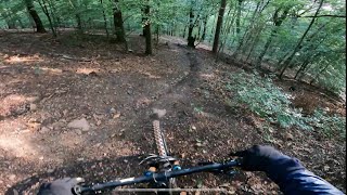
In Schlangenlinien gehts den Berg hinab, erst im letzten Abschnitt kommen auch ein paar Steine dazu. Ca. 30% Gefälle.

This trail is unsanctioned.

Tags
Berms

Recent Activity on Trail

Past Week
  • 1 rides
  • 23.5 km average
6 Months
  • 8 rides
  • 20.6 km avg distance
All
  • 58 rides
  • Last: Nov 11, 2026
c1c2c3c4
January
February
March
April
May
June
July
August
September
October
November
December
update trails status or condition

SchwippSchwapp Trail Reports

statusdatedescription
Oct 30, 2026 @ 1:34pm (Europe/Luxembourg)
Oct 30, 2026
Oben wie immer im Herbst viel Laub in tiefen Rinnen. Vorletzter Abschnitt gesperrt wegen Forstarbeiten, im Ausstieg musste *zufälligerweise*...
Sep 1, 2026 @ 2:14pm (Europe/Berlin)
Sep 1, 2026
Aktuell liegt im mittleren Teil viel Laub. Durch die teilweise angefangenen neuen Abzweigungen steht man da schnell in einer Sackgasse da die...
Feb 8, 2026 @ 2:33pm (Europe/Berlin)
Feb 8, 2026
Aktuell wunderschön frei von Laub. Danke dafür !!!
Dec 27, 2025 @ 6:41am (Pacific/Midway)
Dec 27, 2025
in the mid- and lower-section lots of fallen leaves
Dec 7, 2025 @ 11:41am (Europe/Luxembourg)
Dec 7, 2025
Wurde vom Laub befreit, sehr gut fahrbar
more »
Status:
on Oct 30, 2026
Dry
Avg: 3.99 (9 votes)
Your vote: 0

view (302)
close
      Directions to schwippschwapp trailhead (49.445010, 8.696320)

      Photos

      5 more »
      mtb
      34 |
      Oct 15, 2026 @ 5:48am
      Oct 15, 2026
      report
      mtb
      184 |
      Apr 4, 2020 @ 4:12am
      Apr 4, 2020
      report
      mtb
      179 |
      Mar 16, 2020 @ 6:40am
      Mar 16, 2020

      Videos

      4 more »
      Downhill MTB Heidelberg Schwip schwap Winter...
      mtb
      2:39 | 401 | Dec 18, 2023 , Heidelberg
      MTB Enduro Tour Rollercoaster Trail |Hoher...
      mtb
      11:15 | 155 | Jan 1, 2023 , Heidelberg
      youtuber Let's Ride MTB - Heidelberg // Weißer Stein...
      mtb
      12:10 | 357 | Mar 30, 2022 , Heidelberg
      Weißer Stein Schwipp Schwapp Downhill RAW...
      mtb
      2:30 | 258 | Nov 7, 2021 , Heidelberg

      Routes with this trail

      more »
      ★ 5.0 • 4 miles • 577 ft • 7 • Point to Point •
      Startpunkt ist am Weißen Stein, wo man das erste Stück Gelbe X mitnimmt (bzw. den alternativen Einstieg)...
      3.9 ★★★★★
      9 Ratings
      5 ★ 44%
      4 ★ 11%
      3 ★ 33%
      2 ★ 11%
      1 ★

      1 Review & Comments

      trailstuermer trailstuermer
      Ziemlich steil. Ich würde den Trail, insbesondere das letzte Stück, nicht als blau sondern schwarz einschätzen. Aber an sich macht der Trail viel Spaß Smile

      We hope you've been enjoying Trailforks!

      Create a FREE account to view all trail reviews and much more.

      • #151602 - 3,221 views

      Frequently Asked Questions

      ▼ Where is SchwippSchwapp located?
      SchwippSchwapp is located in Weißer Stein, Heidelberg, Germany. It is part of the Weißer Stein trail network. The trailhead is located at coordinates 49.44501, 8.69632.
      ▼ How hard is SchwippSchwapp?
      SchwippSchwapp is rated as Red difficulty. The average grade is 29.1%.
      ▼ What is the elevation gain for SchwippSchwapp?
      The trail has 618 ft of elevation descent. The elevation ranges from 766 ft to 1,385 ft.
      ▼ Is SchwippSchwapp a point to point trail?
      Yes, SchwippSchwapp is a point to point trail. The direction is Downhill Only. The trail type is singletrack.
      ▼ How long is SchwippSchwapp?
      SchwippSchwapp is 2,123 ft long. The trail type is singletrack.
      ▼ Are dogs allowed on SchwippSchwapp?
      Yes, dogs are allowed on SchwippSchwapp. Please keep dogs on a leash where required and clean up after them.
      ▼ When is the best time of year to ride SchwippSchwapp?
      Based on activity log data, the most popular months to ride SchwippSchwapp are:
      • July (5 activities)
      • March (4 activities)
      • January (3 activities)
      Check the reports page for current trail conditions.
      ▼ How do I access SchwippSchwapp? Where is the closest parking trailhead?
      The closest parking and trailhead locations to SchwippSchwapp are: View all parking locations in the area.
      ▼ How long does it take to ride SchwippSchwapp?
      Based on recorded activities, it takes an average of 4 minutes to ride SchwippSchwapp. The trail is 2,123 ft long. Actual times will vary based on fitness level, conditions, and pace. View recent activity logs for more details.
      ▼ How busy is SchwippSchwapp?
      SchwippSchwapp is a very popular trail. There have been 400 recorded activities on this trail. The trail has received 302 check-ins. View recent activity on this trail.

      Hit the Trail

      Open in App

      Get this trail on your phone instantly.

      open trail in app

      Download Trail

      Save to wishlist, Garmin & download.
      save the trail

      Find Related Routes

      Find routes and users activities that include this trail.
      find routes for this trail

      You must enter a description before submitting.

