2.3 miles
Distance
422 ft
Climb
-480 ft
Descent
00:26:30
Avg time
Supporters, Builders, Maintainers & Land Managers of Second Finger Trail
  • BLM
    BLM
    Land Manager

Second Finger Details

  • Activities
    • Mountain Bike
    • Hike
    • Trail Running
  • Riding Area
    Cowboy Trails
    Las Vegas, Nevada
  • Difficulty Rating
  • Voted Difficulty
    Black Diamond (1 vote)
  • Hiking SAC Scale
    T1 Hiking
  • Trail Type
    Singletrack
  • Direction
    Both Directions
    Popular direction shown
  • Climb Difficulty
    Black Diamond
  • Physical Rating
    Hard
  • Dogs Allowed
    Yes
  • Global Ranking
    #77671 in Mountain Biking [+]
    • #12361 in Trail Running
  • Local Popularity
    25 in Mountain Biking [+]
    • 50 in Trail Running
    • 5 in Hiking

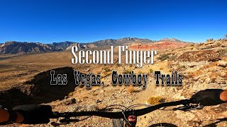
Fun, loose fast descent to edge of Mesa. Few drops. Tip of finger is a great place to chill. The pedal out not terribly fun. Continually rocky, slowish climb. Lots of work. Some exposure. When you have time it is a good added loop. Worth riding it at least once.

Local Trail Association
More Stats for Second Finger mountain bike trail trail
  • Altitude change
    -58 ft
  • Altitude min
    4,177 ft
  • Altitude max
    4,544 ft
  • Altitude start
    4,543 ft
  • Altitude end
    4,485 ft
  • Grade
    -0.472%
  • Grade max
    -25.748%
  • Grade min
    15.386%
  • Distance climb
    1 mile
  • Distance down
    1 mile
  • Distance flat
    616 ft
  • Avg time
    00:26:30
  • Avg reverse time
    00:43:02
  • view trail stats
Status:
on Dec 19, 2022
Dry
Avg: 3.82 (7 votes)
Your vote: 0

view (150)
close
3D
Trail Conditions
  • Unknown
  • Snow Groomed
  • Snow Packed
  • Snow Covered
  • Snow Cover Partial
  • Freeze/thaw Cycle
  • Icy
  • Prevalent Mud
  • Wet
  • Variable
  • Ideal
  • Dry
  • Very Dry
Trail Flow (Ridden Direction)
Trailforks scans users ridelogs to determine the most popular direction each trail is ridden. A good flowing trail network will have most trails flowing in a single direction according to their intension.
The colour categories are based on what percentage of riders are riding a trail in its intended direction.
  • > 96%
  • > 90%
  • > 80%
  • > 70%
  • > 50%
  • < 50%
  • bi-directional trail
  • no data
Trail Last Ridden
Trailforks scans ridelogs to determine the last time a trail was ridden.
  • < 2 days
  • < 1 week
  • < 2 weeks
  • < 1 month
  • < 6 months
  • > 6 months
Trail Ridden Direction
The intended direction a trail should be ridden.
  • Downhill Only
  • Downhill Primary
  • Both Directions
  • Uphill Primary
  • Uphill Only
  • One Direction
Contribute Details
Colors indicate trail is missing specified detail.
  • Description
  • Photos
  • Description & Photos
  • Videos
Trail Popularity ?
Trailforks scans ridelogs to determine which trails are ridden the most in the last 9 months. Trails are compared with nearby trails in the same city region with a possible 25 colour shades. Think of this as a heatmap, more rides = more kinetic energy = warmer colors.
  • most popular
  • popular
  • less popular
  • not popular
ATV/ORV/OHV Filter
Max Vehicle Width
inches
US Cell Coverage
Legend
cell carrier legend

Radar Time
x Activity Recordings
Trailforks users anonymized public ridelogs from the past 6 months.
  • mountain biking recent
  • mountain biking (>6 month)
  • hiking (1 year)
  • moto (1 year)
Activity Recordings
Trailforks users anonymized public skilogs from the past 12 months.
  • Downhill Ski
  • Backcountry Ski
  • Nordic Ski
  • Snowmobile
Winter Trails
Warning A routing network for winter maps does not exist. Selecting trails using the winter trails layer has been disabled.
x Missing Trails
Most Popular
Least Popular
Trails are colored based on popularity. The more popular a trail is, the more red. Less popular trails trend towards green.
Jump Magnitude Heatmap
Heatmap of where riders jump on trails. Zoom in to see individual jumps, click circles to view jump details.
Trails Deemphasized
Trails are shown in grey.
disable
Only show trails with NO bikes.
enable

Save the current map location and zoom level as your default home location whenever this page is loaded.

Save
      Directions to second-finger trailhead (36.102600, -115.412010)
      update trails status or condition

      Second Finger Trail Reports

      statusdatedescription
      Dec 19, 2022 @ 3:03am
      Dec 19, 2022
      Mar 7, 2021 @ 10:01am
      Mar 7, 2021
      reporter
      Apr 7, 2020 @ 7:43am
      Apr 7, 2020
      Trail is underused and overgrown
      Feb 10, 2018 @ 8:39am
      Feb 10, 2018
      view all reports »

      Recent Ridelog Activity on Trail

      Past Week
      • 0 rides
      •  
      6 Months
      • 1 rides
      • 19 miles avg distance
      All
      • 17 rides
      • Last: Mar 8, 2025

      Photos

      more »
      15 |
      Jul 23, 2022 @ 10:02am
      Jul 23, 2022
      19 |
      Jul 23, 2022 @ 10:02am
      Jul 23, 2022
      42 |
      Jan 23, 2022 @ 8:00pm
      Jan 23, 2022

      Routes with this trail

      titledistance
      There's More to Vegas Than Casinos14 miles
      Cowboy Trails Round Up Tour12 miles

      3 Reviews & Comments


      We hope you've been enjoying Trailforks!

      Create a FREE account to view trail comments and much more.

      Videos

      more »
      This trail has some views! Riding Second...
      2:45 | 100 | Nov 3, 2022 , Las Vegas
      New Bike Day! Disappointing Finish
      3:32 | 223 | May 20, 2020 , Las Vegas

      Nearby Trails

      You must enter a description before submitting.