1.1 miles
Distance
110 ft
Climb
-152 ft
Descent
00:09:47
Avg time
Supporters, Builders, Maintainers & Land Managers of Silkworm Trail
  • Sponsor

Silkworm Details

  • Activities
    • Mountain Bike
    • E-Bike
    • Hike
    • Trail Running
  • Riding Area
    Tapeworm
    Renton, Washington
  • Difficulty Rating
  • Voted Difficulty
    Green (4 votes)
  • Trail Type
    Singletrack
  • Bike Type
    AM, XC
  • Direction
    One Direction
  • Climb Difficulty
    Green
  • Physical Rating
    Easy
  • Family Friendly
    Yes
  • Dogs Allowed
    Yes
  • eBike Allowed
    Yes up to Class 1
  • TTFs on Trail
    A-Frame, Bridge, Drop, Jump, Gap Jump, Ladder Bridge, Roller Coaster, Skinny, Teeter Totter, Wallride
  • Ride in Rain
    Yes
  • Global Ranking
    #3577 in Mountain Biking [+]
    • #23953 in E-Biking
    • #41841 in Trail Running
    • #17855 in Hiking
  • Local Popularity
    100 in Mountain Biking [+]
    • 90 in E-Biking
    • 5 in Trail Running
    • 5 in Hiking

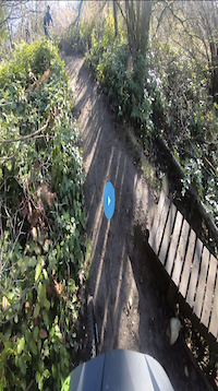
Super fun flowy trail with lots of undulating ups and down. Built within a tight space and engineered quite remarkably. Lots of fun wooden features to play on, a couple raised bridges, a medium size drop and a really cool teeter totter to finish things off.

Local Trail Association
Traditionally Indigenous Territory
More Stats for Silkworm mountain bike trail trail
  • Altitude change
    -44 ft
  • Altitude min
    390 ft
  • Altitude max
    440 ft
  • Altitude start
    440 ft
  • Altitude end
    397 ft
  • Grade
    -0.7%
  • Grade max
    -25%
  • Grade min
    19.5%
  • Distance climb
    1,342 ft
  • Distance down
    1,814 ft
  • Distance flat
    2,680 ft
  • Avg time
    00:09:47
  • Avg reverse time
    00:19:26
  • view trail stats
Status:
on Oct 21, 2024
Ideal
Avg: 4.35 (22 votes)
Your vote: 0

view (7,919)
close
3D
Trail Conditions
  • Unknown
  • Snow Groomed
  • Snow Packed
  • Snow Covered
  • Snow Cover Partial
  • Freeze/thaw Cycle
  • Icy
  • Prevalent Mud
  • Wet
  • Variable
  • Ideal
  • Dry
  • Very Dry
Trail Flow (Ridden Direction)
Trailforks scans users ridelogs to determine the most popular direction each trail is ridden. A good flowing trail network will have most trails flowing in a single direction according to their intension.
The colour categories are based on what percentage of riders are riding a trail in its intended direction.
  • > 96%
  • > 90%
  • > 80%
  • > 70%
  • > 50%
  • < 50%
  • bi-directional trail
  • no data
Trail Last Ridden
Trailforks scans ridelogs to determine the last time a trail was ridden.
  • < 2 days
  • < 1 week
  • < 2 weeks
  • < 1 month
  • < 6 months
  • > 6 months
Trail Ridden Direction
The intended direction a trail should be ridden.
  • Downhill Only
  • Downhill Primary
  • Both Directions
  • Uphill Primary
  • Uphill Only
  • One Direction
Contribute Details
Colors indicate trail is missing specified detail.
  • Description
  • Photos
  • Description & Photos
  • Videos
Trail Popularity ?
Trailforks scans ridelogs to determine which trails are ridden the most in the last 9 months. Trails are compared with nearby trails in the same city region with a possible 25 colour shades. Think of this as a heatmap, more rides = more kinetic energy = warmer colors.
  • most popular
  • popular
  • less popular
  • not popular
ATV/ORV/OHV Filter
Max Vehicle Width
inches
US Cell Coverage
Legend
cell carrier legend

Radar Time
x Activity Recordings
Trailforks users anonymized public ridelogs from the past 6 months.
  • mountain biking recent
  • mountain biking (>6 month)
  • hiking (1 year)
  • moto (1 year)
Activity Recordings
Trailforks users anonymized public skilogs from the past 12 months.
  • Downhill Ski
  • Backcountry Ski
  • Nordic Ski
  • Snowmobile
Winter Trails
Warning A routing network for winter maps does not exist. Selecting trails using the winter trails layer has been disabled.
x Missing Trails
Most Popular
Least Popular
Trails are colored based on popularity. The more popular a trail is, the more red. Less popular trails trend towards green.
Jump Magnitude Heatmap
Heatmap of where riders jump on trails. Zoom in to see individual jumps, click circles to view jump details.
Trails Deemphasized
Trails are shown in grey.
disable
Only show trails with NO bikes.
enable

Save the current map location and zoom level as your default home location whenever this page is loaded.
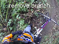
Save
      Directions to silkworm trailhead (47.471020, -122.193100)
      update trails status or condition

      Silkworm Trail Reports

      statusdatedescription
      Oct 21, 2024 @ 12:06am
      Oct 21, 2024
      Aug 13, 2024 @ 12:53pm
      Aug 13, 2024
      Mar 24, 2024 @ 2:21pm
      Mar 24, 2024
      Running great
      Sep 16, 2023 @ 10:20am
      Sep 16, 2023
      Jul 8, 2023 @ 8:59pm
      Jul 8, 2023
      Perfect conditions and smooth riding. Didn't hit any features though.
      view all reports »

      Recent Ridelog Activity on Trail

      Past Week
      • 3 rides
      • 5 miles avg distance
      6 Months
      • 74 rides
      • 5 miles avg distance
      All
      • 907 rides
      • Last: May 16, 2025

      Technical Trail Features (TTF)

      Photos

      more »
      125 |
      Apr 24, 2022 @ 12:31pm
      Apr 24, 2022
      109 |
      Apr 24, 2022 @ 12:30pm
      Apr 24, 2022
      121 |
      Oct 3, 2021 @ 2:28pm
      Oct 3, 2021
      192 |
      Aug 26, 2020 @ 11:01am
      Aug 26, 2020

      Routes with this trail

      titledistance
      Tapeworm Time Trail Course (2023) race7 miles

      4 Reviews & Comments


      We hope you've been enjoying Trailforks!

      Create a FREE account to view trail comments and much more.

      Videos

      more »
      All The Fun Features On Silkworm Mtb Trail
      0:23 | 739 | Dec 15, 2020 , Renton
      Silkworm Sept 01 2019
      9:54 | 1102 | Sep 7, 2019 , Renton
      Drop fail
      | Dec 14, 2020 , Renton
      Dirtnap on Silkworm
      0:35 | 797 | Feb 12, 2012 , Renton
      • By ejbozlee & contributors
      • #28491 - 7,713 views

      You must enter a description before submitting.