more stats
1.0 mile
Distance
18 ft
Climb
-343 ft
Descent
00:05:58
Avg time
-325 ft
Altitude change
8,382 ft
Altitude min
8,707 ft
Altitude max
8,707 ft
Altitude start
8,383 ft
Altitude end
-6.1%
Grade
-40.8%
Grade max
22.1%
Grade min
748 ft
Distance climb
3,976 ft
Distance down
630 ft
Distance flat
00:05:58
Avg time

Silver Queen, Upper Details

  • Activities
    • Mountain Bike
    • Adaptive Bike
  • Riding Area
    Park City Mountain Resort
    Park City, Utah
  • Difficulty Rating
  • Voted Difficulty
    Blue (1 vote)
  • Local Popularity
    100 in Mountain Biking
  • Global Ranking
    #34732 in Mountain Biking
  • Trail Type
    Singletrack
  • Bike Type
    DH, AM, XC, Adaptive MTB
  • Direction
    Downhill Only
    Popular Direction Shown
  • Physical Rating
    Moderate
  • Trail Visibility
    Always easy to follow
  • TTFs on Trail
    Berm, Jump

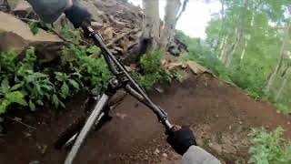
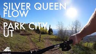
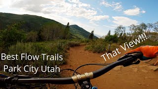
This DH only trail provides another way to drop off the 5-Way at the yurt. The trail is pretty fast and flowing with big swooping berms that take you quickly through the aspens, underneath the chair-lift and out into some open ski runs with views of PCMR. Trail ends at Mid Mountain trail.

Adaptive Bike Info
aMTB Blue Rating: Intermediate features and steeper terrain.

Great aMTB downhill. 36-48” wide. Some tighter high berms but total riot. Jumps roll. Some doubles could give riders trouble.

Local Trail Association
Traditionally Indigenous Territory

Recent Activity on Trail

Past Week
  • 42 rides
  • 16 miles average
6 Months
  • 239 rides
  • 15 miles avg distance
All
  • 2,188 rides
  • Last: Jul 4, 2026
c1c2c3c4
January
February
March
April
May
June
July
August
September
October
November
December
Status:
on Jun 22, 2026
Very Dry
Avg: 4.12 (27 votes)
Your vote: 0

view (12,765)
close
3D
Trail Conditions
  • Unknown
  • Snow Groomed
  • Snow Packed
  • Snow Covered
  • Snow Cover Partial
  • Freeze/thaw Cycle
  • Icy
  • Prevalent Mud
  • Wet
  • Variable
  • Ideal
  • Dry
  • Very Dry
Trail Flow (Ridden Direction)
Trailforks scans users ridelogs to determine the most popular direction each trail is ridden. A good flowing trail network will have most trails flowing in a single direction according to their intension.
The colour categories are based on what percentage of riders are riding a trail in its intended direction.
  • > 96%
  • > 90%
  • > 80%
  • > 70%
  • > 50%
  • < 50%
  • bi-directional trail
  • no data
Trail Last Ridden
Trailforks scans ridelogs to determine the last time a trail was ridden.
  • < 2 days
  • < 1 week
  • < 2 weeks
  • < 1 month
  • < 6 months
  • > 6 months
Trail Ridden Direction
The intended direction a trail should be ridden.
  • Downhill Only
  • Downhill Primary
  • Both Directions
  • Uphill Primary
  • Uphill Only
  • One Direction
Contribute Details
Colors indicate trail is missing specified detail.
  • Description
  • Photos
  • Description & Photos
  • Videos
Trail Popularity ?
Trailforks scans ridelogs to determine which trails are ridden the most in the last 9 months. Trails are compared with nearby trails in the same city region with a possible 25 colour shades. Think of this as a heatmap, more rides = more kinetic energy = warmer colors.
  • most popular
  • popular
  • less popular
  • not popular
ATV/ORV/OHV Filter
Max Vehicle Width
inches
US Cell Coverage
Legend
cell carrier legend

Radar Time
Activity Recordings
Trailforks uses anonymized public activity data. ?
Activity Recordings
Trailforks uses anonymized public activity data. ?
Personal Heatmap
Activity Types
all / none
Options
2
Date range month
Winter Trails
Warning A routing network for winter maps does not exist. Selecting trails using the winter trails layer has been disabled.
Missing Trails
Most Popular
Least Popular
Trails are colored based on popularity. The more popular a trail is, the more red. Less popular trails trend towards green.
Jump Magnitude Heatmap
Heatmap of where riders jump on trails. Zoom in to see individual jumps, click circles to view jump details.
BC Backroad Status

Service Road Atlas is a free to use, community-driven service for viewing and creating reports on the numerous back-country service roads around B.C. and Alberta.

map legend
Slope Aspect
Direction the slope faces
Flat N NE E SE S SW W NW
Trails Deemphasized
Trails are shown in grey.
disable
Only show trails with no bike usage.
Enable
Suggested Layers
Based on selected activity type

    Save the current map location and zoom level as your default home location whenever this page is loaded.

    Save
        Directions to silver-queen-upper trailhead (40.630620, -111.520050)

        Photos

        7 more »
        82 |
        Oct 9, 2022 @ 11:35am
        Oct 9, 2022
        92 |
        Oct 9, 2022 @ 11:35am
        Oct 9, 2022
        156 |
        Jul 30, 2021 @ 8:23am
        Jul 30, 2021
        144 |
        Jul 30, 2021 @ 8:23am
        Jul 30, 2021

        Videos

        4 more »
        Silverqueen // Redbull // Crescent Mine Grade...
        16:05 | 342 | Aug 21, 2022 , Park City
        Silver Queen – Park City, UT  |  T2B Bike  |...
        3:45 | 301 | Jun 22, 2021 , Park City
        Silver Queen Mountain Bike Trail // Park City, UT
        3:39 | 352 | Jun 21, 2021 , Park City
        Best Flow Trails in Park City Utah With...
        10:04 | 345 | Jul 31, 2020 , Park City

        Routes with this trail

        3.5 12 miles 2,071 ft 6
        Up Jenni's > Mid Moutain > Tommy Two Steps to the Yurt. Down > > Crescent Mine Grade ( ) > .
        9 miles 1,063 ft 4
        From near Montage Hotel, ride North on , climb Two Step up to descent, return ride back to trailhead.
        7 miles 489 ft 4
        2023 Sport+ route for Midweek Mini-Enduro

        7 Reviews & Comments


        We hope you've been enjoying Trailforks!

        Create a FREE account to view trail comments and much more.

        Nearby Trails

        • By toddTF Pro Trailforks & contributors
        • #145086 - 6,818 views

        Frequently Asked Questions About Silver Queen, Upper

        Where is Silver Queen, Upper located?
        Silver Queen, Upper is located in Park City Mountain Resort, Park City, Utah, United States. It is part of the Park City Mountain Resort trail network. The trailhead is located at coordinates 40.63062, -111.52005.
        How hard is Silver Queen, Upper?
        Silver Queen, Upper is rated as Blue difficulty. The physical rating is Moderate. The average grade is 6.1%.
        What is the elevation gain for Silver Queen, Upper?
        Silver Queen, Upper has 18 ft of elevation gain. The trail has 343 ft of elevation descent. The elevation ranges from 8,382 ft to 8,707 ft.
        Is Silver Queen, Upper a point to point trail?
        Yes, Silver Queen, Upper is a point to point trail. The direction is Downhill Only. The trail type is singletrack.

        Hit the Trail

        Open in App

        Get this trail on your phone instantly.
        open trail in app

        Download Trail

        Save to wishlist, Garmin & download.
        save the trail

        Find Related Routes

        Find routes and users activities that include this trail.
        find routes for this trail

        You must enter a description before submitting.