more stats
994 ft
Distance
-42 ft
Descent
00:03:50
Avg time
-43 ft
Altitude change
860 ft
Altitude min
902 ft
Altitude max
902 ft
Altitude start
860 ft
Altitude end
-4.3%
Grade
-11.6%
Grade max
-0.3%
Grade min
801 ft
Distance down
00:03:50
Avg time

Slime Details

  • Activities
    • Mountain Bike
    • Hike
    • Trail Running
  • Riding Area
    State Patrol Trails
    Kennewick, Washington
  • Difficulty Rating
  • Local Popularity
    65 in Mountain Biking [+]
    • 5 in Trail Running
    • 5 in Hiking
  • Global Ranking
    #100942 in Mountain Biking [+]
    • #291054 in Trail Running
    • #305177 in Hiking
  • Trail Type
    Singletrack
  • Bike Type
    AM, XC
  • Climb Difficulty
    Black Diamond
  • Physical Rating
    Moderate
  • Dogs Allowed
    Yes
  • eBike Allowed
  • TTFs on Trail
    Bridge, Drop, Jump, Wallride

No community description for Slime trail has been added yet!

AI Generated Description

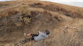
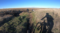
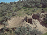
Slime is a 994 ft moderately popular black diamond difficulty singletrack trail located near Kennewick Washington. This mountain bike primary trail and has a moderate overall physical rating with a 0 ft black diamond climb. It features bridge, drop, jump and wallride. On average it takes 3 minutes to complete this trail.

Local Trail Association
Traditionally Indigenous Territory

Recent Activity on Trail

Past Week
  • 0 rides
  •  
6 Months
  • 2 rides
  • 12 miles avg distance
All
  • 29 rides
  • Last: May 5, 2026
c1c2c3c4
January
February
March
April
May
June
July
August
September
October
November
December
update trails status or condition

Slime Trail Reports

statusdatedescription
Mar 25, 2026 @ 10:32am (America/Los_Angeles)
Mar 25, 2026
Feb 22, 2024 @ 7:59pm
Feb 22, 2024
Feb 11, 2024 @ 6:38pm
Feb 11, 2024
Trail is overgrown, but will get worked on overtime. Eventually will be back in service by March 25th. Worked on the run in a little bit clearing...
Apr 23, 2023 @ 7:31am
Apr 23, 2023
May 27, 2022 @ 7:37pm
May 27, 2022
pretty overgrown. jumps are sweet though
more »
Status:
on Mar 25, 2026
Ideal
Avg: 3.84 (1 votes)
Your vote: 0

view (154)
close
3D
Trail Conditions
  • Unknown
  • Snow Groomed
  • Snow Packed
  • Snow Covered
  • Snow Cover Partial
  • Freeze/thaw Cycle
  • Icy
  • Prevalent Mud
  • Wet
  • Variable
  • Ideal
  • Dry
  • Very Dry
Trail Flow (Ridden Direction)
Trailforks scans users ridelogs to determine the most popular direction each trail is ridden. A good flowing trail network will have most trails flowing in a single direction according to their intension.
The colour categories are based on what percentage of riders are riding a trail in its intended direction.
  • > 96%
  • > 90%
  • > 80%
  • > 70%
  • > 50%
  • < 50%
  • bi-directional trail
  • no data
Trail Last Ridden
Trailforks scans ridelogs to determine the last time a trail was ridden.
  • < 2 days
  • < 1 week
  • < 2 weeks
  • < 1 month
  • < 6 months
  • > 6 months
Trail Ridden Direction
The intended direction a trail should be ridden.
  • Downhill Only
  • Downhill Primary
  • Both Directions
  • Uphill Primary
  • Uphill Only
  • One Direction
Contribute Details
Colors indicate trail is missing specified detail.
  • Description
  • Photos
  • Description & Photos
  • Videos
Trail Popularity ?
Trailforks scans ridelogs to determine which trails are ridden the most in the last 9 months. Trails are compared with nearby trails in the same city region with a possible 25 colour shades. Think of this as a heatmap, more rides = more kinetic energy = warmer colors.
  • most popular
  • popular
  • less popular
  • not popular
ATV/ORV/OHV Filter
Max Vehicle Width
inches
US Cell Coverage
Legend
cell carrier legend

Radar Time
Activity Recordings
Trailforks uses anonymized public activity data. ?
Activity Recordings
Trailforks uses anonymized public activity data. ?
Personal Heatmap
Activity Types
all / none
Options
2
Date range month
Winter Trails
Warning A routing network for winter maps does not exist. Selecting trails using the winter trails layer has been disabled.
Missing Trails
Most Popular
Least Popular
Trails are colored based on popularity. The more popular a trail is, the more red. Less popular trails trend towards green.
Jump Magnitude Heatmap
Heatmap of where riders jump on trails. Zoom in to see individual jumps, click circles to view jump details.
BC Backroad Status

Service Road Atlas is a free to use, community-driven service for viewing and creating reports on the numerous back-country service roads around B.C. and Alberta.

map legend
Slope Aspect
Direction the slope faces
Flat N NE E SE S SW W NW
Trails Deemphasized
Trails are shown in grey.
disable
Only show trails with no bike usage.
Enable
Suggested Layers
Based on selected activity type

    Save the current map location and zoom level as your default home location whenever this page is loaded.

    Save
        Directions to slime trailhead (46.158540, -119.181380)

        Photos

        3 more »
        52 |
        Dec 16, 2025 @ 6:13pm
        Dec 16, 2025
        346 |
        Apr 4, 2011 @ 8:02pm
        Apr 4, 2011
        568 |
        Apr 8, 2011 @ 8:42am
        Apr 8, 2011

        Videos

        4 more »
        Slime trail state patrol
        8:09 | 2 | May 28, 2026 , Kennewick
        Slime Canyon Line
        0:45 | 54 | Jan 11, 2025 , Kennewick
        kennewick wa dirt jumps
        0:20 | 797 | Apr 8, 2011 , Kennewick
        kennewick wa dirt jumps
        0:07 | 438 | Apr 8, 2011 , Kennewick

        1 Review & Comments


        We hope you've been enjoying Trailforks!

        Create a FREE account to view trail comments and much more.

        Frequently Asked Questions About Slime

        Where is Slime located?
        Slime is located in State Patrol Trails, Kennewick, Washington, United States. It is part of the State Patrol Trails trail network. The trailhead is located at coordinates 46.15534, -119.18358.
        How hard is Slime?
        Slime is rated as Black Diamond difficulty. The physical rating is Moderate. The average grade is 6.3%. The climb difficulty is rated Black Diamond.
        What is the elevation gain for Slime?
        The trail has 146 ft of elevation descent. The elevation ranges from 860 ft to 1,006 ft.
        Is Slime a point to point trail?
        Slime is not a point to point trail. The direction is Downhill Primary. The trail type is singletrack.

        Hit the Trail

        Open in App

        Get this trail on your phone instantly.
        open trail in app

        Download Trail

        Save to wishlist, Garmin & download.
        save the trail

        Find Related Routes

        Find routes and users activities that include this trail.
        find routes for this trail

        You must enter a description before submitting.