

more stats
1,417 ft
Distance
-72 ft
Descent
00:01:38
Avg time
-74 ft
Altitude change
308 ft
Altitude min
383 ft
Altitude max
382 ft
Altitude start
308 ft
Altitude end
-5.2%
Grade
-17.6%
Grade max
1.3%
Grade min
49 ft
Distance climb
1,198 ft
Distance down
171 ft
Distance flat
00:01:38
Avg time

Sole Trail Details

  • Activities
    • Mountain Bike
    • E-Bike
    • Winter Fat Bike
    • Hike
    • Trail Running
    • Nordic Ski
  • Riding Area
    Marsh Creek State Park
    Downingtown, Pennsylvania
  • Difficulty Rating
  • Voted Difficulty
    Blue (4 votes)
  • Local Popularity
    100 in Mountain Biking [+]
    • 100 in E-Biking
    • 85 in Trail Running
    • 80 in Hiking
    • 5 in Nordic Skiing
    • 5 in Winter Fat Biking
  • Global Ranking
    #29393 in Mountain Biking [+]
    • #6180 in E-Biking
    • #121257 in Trail Running
    • #120511 in Hiking
    • #26245 in Nordic Skiing
    • #7056 in Winter Fat Biking
  • State Ranking
    #360 in Mountain Biking · Pennsylvania [+]
    • #7 in E-Biking
    • #1,878 in Trail Running
    • #2,148 in Hiking
    • #241 in Nordic Skiing
    • #32 in Winter Fat Biking
  • Trail Type
    Singletrack
  • Bike Type
    AM, XC, Fat
  • Direction
    Both Directions
  • Climb Difficulty
    Blue
  • Physical Rating
    Moderate
  • Trail Visibility
    Always easy to follow
  • eBike Allowed
    Yes up to Class 1
  • TTFs on Trail
    Berm, Bridge, Drop, Ladder Bridge, Skinny
  • Land Owner
    DCNR

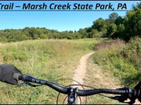
Sole trail is a short but fun (mostly) downward trail if ridden from the Lakeside Trail Extension. There are great views riding along the lake leading up to the start of the trail. The trail is 100% singletrack with tight, twisty sections and a few small berms. Towards the bottom there is a small root drop on the right side of the trail. The trail ends after the small wooden bridge.

Traditionally Indigenous Territory

Recent Activity on Trail

Past Week
  • 12 rides
  • 11 miles average
6 Months
  • 277 rides
  • 12 miles avg distance
All
  • 2,212 rides
  • Last: Oct 27, 2026
Status:
on Sep 19, 2026
Dry
Avg: 4.41 (6 votes)
Your vote: 0

view (13,840)
close
      Directions to sole-trail trailhead (40.056390, -75.714610)

      Photos

      1 more »
      report
      mtb
      115 |
      Mar 15, 2023 @ 2:47pm
      Mar 15, 2023

      Videos

      2 more »
      Mountain Biking at Marsh Creek State Park (PA)...
      mtb
      4:14 | 244 | Aug 17, 2023 , Downingtown
      Sole Trail - Marsh Creek State Park, PA
      mtb
      0:43 | 285 | Sep 20, 2020 , Downingtown

      Routes with this trail

      15 miles • 1,368 ft • 27 • Loop •
      A taste of both the South-East and the North West-Side, starting from the Dorland Mills (Cheater) lot.
      4.9 ★★★★★
      6 Ratings
      5 ★ 83%
      4 ★ 17%
      3 ★
      2 ★
      1 ★

      3 Reviews & Comments

      rickv85 rickv85
      Definitely one of the better downhills at Marsh Creek but there’s no drop on this.
      dkrk279 dkrk279
      I rated it blue because of the tight and twisty downward flow (if ridden from the lake). It also has a drop on it. It's close to green but fun enough to give it the blue rating.

      We hope you've been enjoying Trailforks!

      Create a FREE account to view all trail reviews and much more.

      • By UncleChimneyTF Pro & contributors
      • #87381 - 1,843 views

      Frequently Asked Questions

      ▼ Where is Sole Trail located?
      Sole Trail is located in Marsh Creek State Park, Downingtown, Pennsylvania, United States. It is part of the Marsh Creek State Park trail network. The trailhead is located at coordinates 40.05639, -75.71461.
      ▼ How hard is Sole Trail?
      Sole Trail is rated as Blue difficulty. The physical rating is Moderate. The average grade is 5.2%. The climb difficulty is rated Blue.
      ▼ What is the elevation gain for Sole Trail?
      The trail has 72 ft of elevation descent. The elevation ranges from 308 ft to 383 ft.
      ▼ Is Sole Trail a point to point trail?
      Sole Trail is not a point to point trail. The direction is Both Directions. The trail type is singletrack.
      ▼ How long is Sole Trail?
      Sole Trail is 1,417 ft long. The trail type is singletrack.
      ▼ Are dogs allowed on Sole Trail?
      There is no information about dogs being allowed on Sole Trail. Check with local trail managers or the trail page for the latest access rules.
      ▼ How do I access Sole Trail? Where is the closest parking trailhead?
      The closest parking and trailhead locations to Sole Trail are: View all parking locations in the area.
      ▼ How long does it take to ride Sole Trail?
      Based on recorded activities, it takes an average of 2 minutes to ride Sole Trail. The trail is 1,417 ft long. Actual times will vary based on fitness level, conditions, and pace. View recent activity logs for more details.
      ▼ How busy is Sole Trail?
      Sole Trail is a very popular trail. There have been 9,643 recorded activities on this trail. The trail has received 13,840 check-ins. View recent activity on this trail.

      Hit the Trail

      Open in App

      Get this trail on your phone instantly.

      open trail in app

      Download Trail

      Save to wishlist, Garmin & download.
      save the trail

      Find Related Routes

      Find routes and users activities that include this trail.
      find routes for this trail

      You must enter a description before submitting.

