more stats
2,385 ft
Distance
71 ft
Climb
-5 ft
Descent
00:04:40
Avg time
66 ft
Altitude change
217 ft
Altitude min
282 ft
Altitude max
217 ft
Altitude start
282 ft
Altitude end
2.8%
Grade
-2.5%
Grade max
24.1%
Grade min
1,759 ft
Distance climb
515 ft
Distance down
108 ft
Distance flat
00:04:40
Avg time

Speed Section Details

  • Activities
    • Mountain Bike
    • Hike
    • Trail Running
  • Riding Area
    Miłosna
    Kwidzyn
  • AKA
    Karate
  • Difficulty Rating
  • Voted Difficulty
    Blue (1 vote)
  • Local Popularity
    90 in Mountain Biking [+]
    • 5 in Trail Running
    • 5 in Hiking
  • Global Ranking
    #64918 in Mountain Biking [+]
    • #187136 in Trail Running
    • #188094 in Hiking
  • Trail Type
    Singletrack
  • Bike Type
    XC
  • Direction
    Downhill Primary
  • Trail Visibility
    Always easy to follow
  • Dogs Allowed
    Yes
  • eBike Allowed

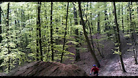
Typowa trasa XC. Zawiera część podjazdową i zjazdową.Stosunkowo łatwa w porównaniu do innych niebieskich szlaków tutaj.

Szlak był częścią kwidzyńskiego etapu Północnej Ligi MTB XC, który odbył się 13 września 2020.

This trail is unsanctioned.

Recent Activity on Trail

Past Week
  • 0 rides
  •  
6 Months
  • 3 rides
  • 25 miles avg distance
All
  • 54 rides
  • Last: May 26, 2026
c1c2c3c4
January
February
March
April
May
June
July
August
September
October
November
December
Status:
on May 26, 2026
Dry
Avg: 3.98 (1 votes)
Your vote: 0

view (324)
close
3D
Trail Conditions
  • Unknown
  • Snow Groomed
  • Snow Packed
  • Snow Covered
  • Snow Cover Partial
  • Freeze/thaw Cycle
  • Icy
  • Prevalent Mud
  • Wet
  • Variable
  • Ideal
  • Dry
  • Very Dry
Trail Flow (Ridden Direction)
Trailforks scans users ridelogs to determine the most popular direction each trail is ridden. A good flowing trail network will have most trails flowing in a single direction according to their intension.
The colour categories are based on what percentage of riders are riding a trail in its intended direction.
  • > 96%
  • > 90%
  • > 80%
  • > 70%
  • > 50%
  • < 50%
  • bi-directional trail
  • no data
Trail Last Ridden
Trailforks scans ridelogs to determine the last time a trail was ridden.
  • < 2 days
  • < 1 week
  • < 2 weeks
  • < 1 month
  • < 6 months
  • > 6 months
Trail Ridden Direction
The intended direction a trail should be ridden.
  • Downhill Only
  • Downhill Primary
  • Both Directions
  • Uphill Primary
  • Uphill Only
  • One Direction
Contribute Details
Colors indicate trail is missing specified detail.
  • Description
  • Photos
  • Description & Photos
  • Videos
Trail Popularity ?
Trailforks scans ridelogs to determine which trails are ridden the most in the last 9 months. Trails are compared with nearby trails in the same city region with a possible 25 colour shades. Think of this as a heatmap, more rides = more kinetic energy = warmer colors.
  • most popular
  • popular
  • less popular
  • not popular
ATV/ORV/OHV Filter
Max Vehicle Width
inches
US Cell Coverage
Legend
cell carrier legend

Radar Time
Activity Recordings
Trailforks uses anonymized public activity data. ?
Activity Recordings
Trailforks uses anonymized public activity data. ?
Personal Heatmap
Activity Types
all / none
Options
2
Date range month
Winter Trails
Warning A routing network for winter maps does not exist. Selecting trails using the winter trails layer has been disabled.
Missing Trails
Most Popular
Least Popular
Trails are colored based on popularity. The more popular a trail is, the more red. Less popular trails trend towards green.
Jump Magnitude Heatmap
Heatmap of where riders jump on trails. Zoom in to see individual jumps, click circles to view jump details.
BC Backroad Status

Service Road Atlas is a free to use, community-driven service for viewing and creating reports on the numerous back-country service roads around B.C. and Alberta.

map legend
Slope Aspect
Direction the slope faces
Flat N NE E SE S SW W NW
Trails Deemphasized
Trails are shown in grey.
disable
Only show trails with no bike usage.
Enable
Suggested Layers
Based on selected activity type

    Save the current map location and zoom level as your default home location whenever this page is loaded.

    Save
        Directions to speed-section trailhead (53.715640, 18.970820)

        Photos

        No photos have been added for Speed Section yet, add a photo.

        Videos

        1 more »
        karate No foot can can
        0:04 | 407 | May 8, 2012 , Kwidzyn

        Reviews / Comments

        No reviews yet, be the first to write a review or ask a question.
        Use trail reports to comment on trail conditions.


        We hope you've been enjoying Trailforks!

        Create a FREE account to view trail comments and much more.

        Nearby Trails

        • #326083 - 304 views

        Frequently Asked Questions About Speed Section

        Where is Speed Section located?
        Speed Section is located in Miłosna, Kwidzyn, Poland. It is part of the Miłosna trail network. The trailhead is located at coordinates 53.71564, 18.97082.
        How hard is Speed Section?
        Speed Section is rated as Blue difficulty. The average grade is 2.8%.
        What is the elevation gain for Speed Section?
        Speed Section has 71 ft of elevation gain. The trail has 5 ft of elevation descent. The elevation ranges from 217 ft to 282 ft.
        Is Speed Section a point to point trail?
        Speed Section is not a point to point trail. The direction is Downhill Primary. The trail type is singletrack.

        Hit the Trail

        Open in App

        Get this trail on your phone instantly.
        open trail in app

        Download Trail

        Save to wishlist, Garmin & download.
        save the trail

        Find Related Routes

        Find routes and users activities that include this trail.
        find routes for this trail

        You must enter a description before submitting.