more stats
86 ft
Distance
-25 ft
Descent
342 ft
High Point
-25 ft
Altitude change
318 ft
Altitude min
342 ft
Altitude start
318 ft
Altitude end
-28.895%
Grade
-29.846%
Grade max
-27.414%
Grade min
86 ft
Distance down

Steep Details

  • Activities
    • Mountain Bike
  • Riding Area
    Malvina Wood
    Nivelles
  • Difficulty Rating
  • Local Popularity
    5 in Mountain Biking
  • Global Ranking
    #27993 in Mountain Biking
  • Trail Type
    Singletrack
  • Bike Type
    DH
  • Direction
    Downhill Only
  • Season
    ride in all conditions OK !
  • Dogs Allowed
    Yes
  • TTFs on Trail
    Drop
  • Ride in Rain
    Yes
  • Year Opened
    2015

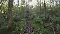
More than 100% of slope (more than -45° from horizontal)... Even if you lock your brakes you still accelerate and it s scary on every ride. Go at your own risks.

La steep est le tracé le plus pentu du spot, et sans doute un des plus pentus en Belgique. Même en freinant à bloc ça accélère, Ca peut faire assez peur les 1ère fois. Soyez prudents.

Trail Supporters

Recent Activity on Trail

Past Week
  • 0 rides
  •  
6 Months
  • 0 rides
  •  
All
  • 1 rides
  • Last: Apr 21, 2020
update trails status or condition

Steep Trail Reports

no reports have been added for Steep yet, add a trail report.
Trail reports are used to indicate a trails current condition and inform builders and other riders about any issues on a trail.
Status:
Avg: 4.13 (1 votes)
Your vote: 0

view (8)
close
3D
Trail Conditions
  • Unknown
  • Snow Groomed
  • Snow Packed
  • Snow Covered
  • Snow Cover Partial
  • Freeze/thaw Cycle
  • Icy
  • Prevalent Mud
  • Wet
  • Variable
  • Ideal
  • Dry
  • Very Dry
Trail Flow (Ridden Direction)
Trailforks scans users ridelogs to determine the most popular direction each trail is ridden. A good flowing trail network will have most trails flowing in a single direction according to their intension.
The colour categories are based on what percentage of riders are riding a trail in its intended direction.
  • > 96%
  • > 90%
  • > 80%
  • > 70%
  • > 50%
  • < 50%
  • bi-directional trail
  • no data
Trail Last Ridden
Trailforks scans ridelogs to determine the last time a trail was ridden.
  • < 2 days
  • < 1 week
  • < 2 weeks
  • < 1 month
  • < 6 months
  • > 6 months
Trail Ridden Direction
The intended direction a trail should be ridden.
  • Downhill Only
  • Downhill Primary
  • Both Directions
  • Uphill Primary
  • Uphill Only
  • One Direction
Contribute Details
Colors indicate trail is missing specified detail.
  • Description
  • Photos
  • Description & Photos
  • Videos
Trail Popularity ?
Trailforks scans ridelogs to determine which trails are ridden the most in the last 9 months. Trails are compared with nearby trails in the same city region with a possible 25 colour shades. Think of this as a heatmap, more rides = more kinetic energy = warmer colors.
  • most popular
  • popular
  • less popular
  • not popular
ATV/ORV/OHV Filter
Max Vehicle Width
inches
US Cell Coverage
Legend
cell carrier legend

Radar Time
Activity Recordings
Trailforks uses anonymized public activity data. ?
Activity Recordings
Trailforks uses anonymized public activity data. ?
Personal Heatmap
Activity Types
all / none
Options
2
Date range month
Winter Trails
Warning A routing network for winter maps does not exist. Selecting trails using the winter trails layer has been disabled.
Missing Trails
Most Popular
Least Popular
Trails are colored based on popularity. The more popular a trail is, the more red. Less popular trails trend towards green.
Jump Magnitude Heatmap
Heatmap of where riders jump on trails. Zoom in to see individual jumps, click circles to view jump details.
BC Backroad Status

Service Road Atlas is a free to use, community-driven service for viewing and creating reports on the numerous back-country service roads around B.C. and Alberta.

map legend
Slope Aspect
Direction the slope faces
Flat N NE E SE S SW W NW
Trails Deemphasized
Trails are shown in grey.
disable
Only show trails with no bike usage.
Enable
Suggested Layers
Based on selected activity type

    Save the current map location and zoom level as your default home location whenever this page is loaded.

    Save
        Directions to steep trailhead (50.675810, 4.554160)

        Photos

        No photos have been added for Steep yet, add a photo.

        Videos

        9 more »
        coal mine shred 27.9.2015
        2:43 | 134 | Sep 28, 2015 , Nivelles
        trails at bergen op zoom
        4:14 | 265 | Mar 25, 2015 , Nivelles
        fixie slalom
        0:05 | 1018 | Sep 21, 2011 , Nivelles
        Down Hill Huy
        7:17 | 163 | Apr 4, 2011 , Nivelles

        Reviews / Comments

        No reviews yet, be the first to write a review or ask a question.
        Use trail reports to comment on trail conditions.


        We hope you've been enjoying Trailforks!

        Create a FREE account to view trail comments and much more.

        • By RedBurn & contributors
        • #54242 - 1,517 views

        Frequently Asked Questions About Steep

        Where is Steep located?
        Steep is located in Malvina Wood, Nivelles, Belgium. It is part of the Malvina Wood trail network. The trailhead is located at coordinates 50.67581, 4.55416.
        How hard is Steep?
        Steep is rated as Proline difficulty. The average grade is 28.895%.
        What is the elevation gain for Steep?
        The trail has 25 ft of elevation descent. The elevation ranges from 318 ft to 342 ft.
        Is Steep a point to point trail?
        Yes, Steep is a point to point trail. The direction is Downhill Only. The trail type is singletrack.

        Hit the Trail

        Open in App

        Get this trail on your phone instantly.
        open trail in app

        Download Trail

        Save to wishlist, Garmin & download.
        save the trail

        Find Related Routes

        Find routes and users activities that include this trail.
        find routes for this trail

        You must enter a description before submitting.