more stats
4,744 ft
Distance
14 ft
Climb
-906 ft
Descent
00:09:17
Avg time
-892 ft
Altitude change
1,912 ft
Altitude min
2,806 ft
Altitude max
2,804 ft
Altitude start
1,913 ft
Altitude end
-18.8%
Grade
-75.8%
Grade max
18.6%
Grade min
207 ft
Distance climb
4,429 ft
Distance down
108 ft
Distance flat
00:09:17
Avg time

STFU Details

  • Activities
    • Mountain Bike
    • E-Bike
  • Riding Area
  • Difficulty Rating
  • Local Popularity
    20 in Mountain Biking [+]
    • 20 in E-Biking
  • Global Ranking
    #40869 in Mountain Biking [+]
    • #101653 in E-Biking
  • Trail Type
    Singletrack
  • Bike Type
    DH, AM, XC
  • Direction
    Downhill Only
    Popular Direction Shown
  • Climb Difficulty
    Double Black Diamond
  • Physical Rating
    Moderate
  • Trail Visibility
    Always easy to follow
  • Season
    All year
  • eBike Allowed
    Yes up to Class 1
  • TTFs on Trail
    Berm, Jump, Rock Garden
  • Ride in Rain
    Yes
  • Year Opened
    2022
  • Land Owner
    HR Šume

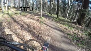
The Trail can be accessed from Kolorado where it crosses hiking trail #16, on the left from the crossing, to the right below trail #16. The trail is nice and flowy up top, a good amount of off camber action, it then enters a zone where the terrain is a little rougher in some parts, but nothing serious, more off camber, then after a jump, the trail crosses to a short steep section followed by a nice technical mix of off camber and and a couple more steeper sections. As a whole not super difficult at all, but it does require being able to handle those off camber section and be willing to commit on the steep parts.

Trail Supporters
  • past supporters

Local Trail Association

Recent Activity on Trail

Past Week
  • 0 rides
  •  
6 Months
  • 0 rides
  •  
All
  • 3 rides
  • Last: Feb 28, 2026
c1c2c3c4
January
February
March
April
May
June
July
August
September
October
November
December
update trails status or condition

STFU Trail Reports

statusdatedescription
May 24, 2026 @ 11:42pm (Europe/Zagreb)
May 24, 2026
Lower section is blocked in multiple locations by downed trees. Trail is closed until a redirect can be done.
Feb 12, 2025 @ 11:50am
Feb 12, 2025
Large tree down across trail, blocking trail
Feb 4, 2025 @ 1:14pm
Feb 4, 2025
Overgrown vegetation
Mar 27, 2024 @ 12:10pm
Mar 27, 2024
Aug 21, 2022 @ 5:07am
Aug 21, 2022
Few fallen trees, otherwise ok. Like previous comment said, in less than ideal conditions this will be "interesting" :)
more »
Status:
on May 24, 2026
Variable
Avg: 4.13 (1 votes)
Your vote: 0

view (40)
close
3D
Trail Conditions
  • Unknown
  • Snow Groomed
  • Snow Packed
  • Snow Covered
  • Snow Cover Partial
  • Freeze/thaw Cycle
  • Icy
  • Prevalent Mud
  • Wet
  • Variable
  • Ideal
  • Dry
  • Very Dry
Trail Flow (Ridden Direction)
Trailforks scans users ridelogs to determine the most popular direction each trail is ridden. A good flowing trail network will have most trails flowing in a single direction according to their intension.
The colour categories are based on what percentage of riders are riding a trail in its intended direction.
  • > 96%
  • > 90%
  • > 80%
  • > 70%
  • > 50%
  • < 50%
  • bi-directional trail
  • no data
Trail Last Ridden
Trailforks scans ridelogs to determine the last time a trail was ridden.
  • < 2 days
  • < 1 week
  • < 2 weeks
  • < 1 month
  • < 6 months
  • > 6 months
Trail Ridden Direction
The intended direction a trail should be ridden.
  • Downhill Only
  • Downhill Primary
  • Both Directions
  • Uphill Primary
  • Uphill Only
  • One Direction
Contribute Details
Colors indicate trail is missing specified detail.
  • Description
  • Photos
  • Description & Photos
  • Videos
Trail Popularity ?
Trailforks scans ridelogs to determine which trails are ridden the most in the last 9 months. Trails are compared with nearby trails in the same city region with a possible 25 colour shades. Think of this as a heatmap, more rides = more kinetic energy = warmer colors.
  • most popular
  • popular
  • less popular
  • not popular
ATV/ORV/OHV Filter
Max Vehicle Width
inches
US Cell Coverage
Legend
cell carrier legend

Radar Time
Activity Recordings
Trailforks uses anonymized public activity data. ?
Activity Recordings
Trailforks uses anonymized public activity data. ?
Personal Heatmap
Activity Types
all / none
Options
2
Date range month
Winter Trails
Warning A routing network for winter maps does not exist. Selecting trails using the winter trails layer has been disabled.
Missing Trails
Most Popular
Least Popular
Trails are colored based on popularity. The more popular a trail is, the more red. Less popular trails trend towards green.
Jump Magnitude Heatmap
Heatmap of where riders jump on trails. Zoom in to see individual jumps, click circles to view jump details.
BC Backroad Status

Service Road Atlas is a free to use, community-driven service for viewing and creating reports on the numerous back-country service roads around B.C. and Alberta.

map legend
Slope Aspect
Direction the slope faces
Flat N NE E SE S SW W NW
Trails Deemphasized
Trails are shown in grey.
disable
Only show trails with no bike usage.
Enable
Suggested Layers
Based on selected activity type

    Save the current map location and zoom level as your default home location whenever this page is loaded.

    Save
        Directions to stfu trailhead (45.899850, 15.972310)

        Photos

        2 more »
        133 |
        Jun 17, 2022 @ 3:12am
        Jun 17, 2022
        122 |
        Jun 17, 2022 @ 3:12am
        Jun 17, 2022
        68 |
        Aug 21, 2022 @ 5:07am
        Aug 21, 2022
        70 |
        Aug 21, 2022 @ 5:07am
        Aug 21, 2022

        Videos

        1 more »
        STFU MTB Trail in Zagreb, Croatia
        4:42 | 90 | Mar 23, 2024 , Zagreb

        Reviews / Comments

        No reviews yet, be the first to write a review or ask a question.
        Use trail reports to comment on trail conditions.


        We hope you've been enjoying Trailforks!

        Create a FREE account to view trail comments and much more.

        Nearby Trails

        • By adkarzenTF Pro & contributors
        • #515922 - 763 views

        Frequently Asked Questions About STFU

        Where is STFU located?
        STFU is located in Zagreb, Croatia. It is part of the Zagreb trail network. The trailhead is located at coordinates 45.89985, 15.97231.
        How hard is STFU?
        STFU is rated as Red difficulty. The physical rating is Moderate. The average grade is 18.8%. The climb difficulty is rated Double Black Diamond.
        What is the elevation gain for STFU?
        STFU has 4 m of elevation gain. The trail has 276 m of elevation descent. The elevation ranges from 583 m to 855 m.
        Is STFU a point to point trail?
        Yes, STFU is a point to point trail. The direction is Downhill Only. The trail type is singletrack.

        Hit the Trail

        Open in App

        Get this trail on your phone instantly.
        open trail in app

        Download Trail

        Save to wishlist, Garmin & download.
        save the trail

        Find Related Routes

        Find routes and users activities that include this trail.
        find routes for this trail

        You must enter a description before submitting.