1.4 miles
Distance
199 ft
Climb
-401 ft
Descent
00:12:23
Avg time

Stonewall Details

  • Activities
    • Mountain Bike
    • E-Bike
    • Horse
    • Hike
    • Trail Running
    • Dirtbike/Moto
  • Riding Area
    Auburn
    , California
  • Difficulty Rating
  • Trail Type
    Doubletrack
  • Bike Type
    AM, XC, Gravel, Adaptive MTB
  • Direction
    Downhill Primary
    Popular direction shown
  • Physical Rating
    Easy
  • Season
    Year round
  • Dogs Allowed
    Yes
  • eBike Allowed
    Yes up to Class 1
  • Ride in Rain
    Yes
  • Global Ranking
    #4040 in Mountain Biking [+]
    • #1023 in E-Biking
    • #9287 in Trail Running
    • #25974 in Hiking
    • #1492 in Dirtbiking
  • Local Popularity
    90 in Mountain Biking [+]
    • 85 in E-Biking
    • 90 in Trail Running
    • 60 in Hiking
    • 5 in Dirtbiking
    • 5 in Horseback

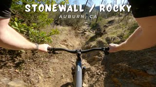
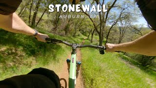
Stonewall is a one-way trail in the Mammoth Bar OHV park. My favorite way to access this trail is after finishing culvert, head into the OHV as though you're heading to confluence. Instead of going right to confluence, turn left and head up the wide dirt road. This climb is the old stagecoach road and has a few spots with a decent view.

Compared to the fast flowing nature of culvert, stonewall feels like an exciting step up. Get a bit of a running start into the start of the trail as a bit of momentum helps keep your speed up for the first short uphill, then get ready for a ride. The trail immediately gets much steeper and chunkier than anything on culvert or confluence. At low speeds, it is easily manageable, but careful if you're pushing yourself, this rollercoaster goes straight into a 180 right hander that requires a hefty handful of brakes to negotiate. Just after this is a steep little pedal, keep your speed up, but be ready to dump gears. After this crest the trail drops into a steep left that hurls you into stonewalls best. Fast and flowy, with rollercoaster like drops and berms, broken a few times by odd off cambers and one rocky left that tends to push people safely off trail. A few more fun turns and you drop back to a double track that often has motorcycles and quads on operational days.

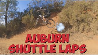
Go down to the right a bit, and choose between Rocky Trail(1/8th mile rock garden), or bombing the fire road to the bottom. Enjoy the climb out It's short, but very steep.

Access Info

In the Mammoth Bar OHV park

Local Trail Association
Traditionally Indigenous Territory
More Stats for Stonewall mountain bike trail trail
  • Altitude change
    -202 ft
  • Altitude min
    874 ft
  • Altitude max
    1,275 ft
  • Altitude start
    1,076 ft
  • Altitude end
    873 ft
  • Grade
    -2.8%
  • Grade max
    -55%
  • Grade min
    24.3%
  • Distance climb
    3,497 ft
  • Distance down
    3,215 ft
  • Distance flat
    459 ft
  • Avg time
    00:12:23
  • Avg reverse time
    00:21:45
  • view trail stats
Status:
on Jan 7, 2025
Variable
Avg: 4.45 (14 votes)
Your vote: 0

view (5,626)
close
3D
Trail Conditions
  • Unknown
  • Snow Groomed
  • Snow Packed
  • Snow Covered
  • Snow Cover Partial
  • Freeze/thaw Cycle
  • Icy
  • Prevalent Mud
  • Wet
  • Variable
  • Ideal
  • Dry
  • Very Dry
Trail Flow (Ridden Direction)
Trailforks scans users ridelogs to determine the most popular direction each trail is ridden. A good flowing trail network will have most trails flowing in a single direction according to their intension.
The colour categories are based on what percentage of riders are riding a trail in its intended direction.
  • > 96%
  • > 90%
  • > 80%
  • > 70%
  • > 50%
  • < 50%
  • bi-directional trail
  • no data
Trail Last Ridden
Trailforks scans ridelogs to determine the last time a trail was ridden.
  • < 2 days
  • < 1 week
  • < 2 weeks
  • < 1 month
  • < 6 months
  • > 6 months
Trail Ridden Direction
The intended direction a trail should be ridden.
  • Downhill Only
  • Downhill Primary
  • Both Directions
  • Uphill Primary
  • Uphill Only
  • One Direction
Contribute Details
Colors indicate trail is missing specified detail.
  • Description
  • Photos
  • Description & Photos
  • Videos
Trail Popularity ?
Trailforks scans ridelogs to determine which trails are ridden the most in the last 9 months. Trails are compared with nearby trails in the same city region with a possible 25 colour shades. Think of this as a heatmap, more rides = more kinetic energy = warmer colors.
  • most popular
  • popular
  • less popular
  • not popular
ATV/ORV/OHV Filter
Max Vehicle Width
inches
US Cell Coverage
Legend
cell carrier legend

Radar Time
x Activity Recordings
Trailforks users anonymized public ridelogs from the past 6 months.
  • mountain biking recent
  • mountain biking (>6 month)
  • hiking (1 year)
  • moto (1 year)
Activity Recordings
Trailforks users anonymized public skilogs from the past 12 months.
  • Downhill Ski
  • Backcountry Ski
  • Nordic Ski
  • Snowmobile
Winter Trails
Warning A routing network for winter maps does not exist. Selecting trails using the winter trails layer has been disabled.
x Missing Trails
Most Popular
Least Popular
Trails are colored based on popularity. The more popular a trail is, the more red. Less popular trails trend towards green.
Jump Magnitude Heatmap
Heatmap of where riders jump on trails. Zoom in to see individual jumps, click circles to view jump details.
Trails Deemphasized
Trails are shown in grey.
disable
Only show trails with NO bikes.
enable

Save the current map location and zoom level as your default home location whenever this page is loaded.

Save
      Directions to stonewall trailhead (38.920780, -121.012450)
      update trails status or condition

      Stonewall Trail Reports

      statusdatedescription
      Jan 7, 2025 @ 6:26pm
      Jan 7, 2025
      muddy in spots, but stonewall is always a blast to ride in the winter
      May 28, 2024 @ 9:23am
      May 28, 2024
      Mar 31, 2024 @ 10:45am
      Mar 31, 2024
      Uphill part from Confluence to Shortcut is clear and free of previous tree
      Jan 29, 2024 @ 3:14pm
      Jan 29, 2024
      Tree down across Stonewall climb trail. Bring a big saw!
      Jan 28, 2024 @ 11:50am
      Jan 28, 2024
      From Tom's Shortcut (0.3 mi from Mammoth Bar) trail is clear and wet with NO TREES down
      view all reports »

      Recent Ridelog Activity on Trail

      Past Week
      • 1 rides
      • 14 miles avg distance
      6 Months
      • 41 rides
      • 11 miles avg distance
      All
      • 590 rides
      • Last: Apr 29, 2025

      Photos

      more »
      103 |
      May 31, 2019 @ 3:25pm
      May 31, 2019
      155 |
      Jun 21, 2018 @ 12:57am
      Jun 21, 2018
      54 |
      Sep 27, 2021 @ 11:19am
      Sep 27, 2021
      52 |
      Sep 27, 2021 @ 11:19am
      Sep 27, 2021

      Routes with this trail

      more »
      titledistance
      Auburn 17 miles
      Foresthill Connector to Confluence Trails11 miles
      Clementine to Culvert, Auburn13 miles
      Auburn Speed Ridge Loop17 miles

      7 Reviews & Comments


      We hope you've been enjoying Trailforks!

      Create a FREE account to view trail comments and much more.

      Videos

      more »
      Stonewall   Auburn, CA   MTB
      0:52 | 14 | Apr 13, 2025 , Auburn
      Stonewall & Rocky / Auburn, CA / MTB
      3:23 | 16 | Mar 5, 2025 , Auburn
      Auburn MTB / Culvert / Stonewall / Rocky /...
      15:55 | 150 | Feb 8, 2022 , Auburn
      MTB NorCal Mandatory Mondays with The Calirado Kid
      11:21 | 130 | Jan 17, 2022 , Auburn
      • By TheBikeNerdTF Pro NWTA & contributors
      • #18036 - 8,927 views

      You must enter a description before submitting.