
more stats
1.1 miles
Distance
14 ft
Climb
-689 ft
Descent
00:18:29
Avg time
-675 ft
Altitude change
3,706 ft
Altitude min
4,389 ft
Altitude max
4,389 ft
Altitude start
3,714 ft
Altitude end
-11.1%
Grade
-50.9%
Grade max
5.9%
Grade min
558 ft
Distance climb
5,085 ft
Distance down
423 ft
Distance flat
00:18:29
Avg time

Super Connected Details

  • Activities
    • Mountain Bike
    • E-Bike
    • Hike
    • Trail Running
  • Riding Area
    King Eddie Plateau
    Vernon, British Columbia
  • Difficulty Rating
  • Local Popularity
    80 in Mountain Biking heatmap [+]
    • 70 in E-Biking
    • 5 in Trail Running
    • 65 in Hiking
  • Global Ranking
    #15111 in Mountain Biking [+]
    • #35414 in E-Biking
    • #349693 in Trail Running
    • #139676 in Hiking
  • Provincial Ranking
    #731 in Mountain Biking · British Columbia [+]
    • #2,406 in E-Biking
    • #13,893 in Trail Running
    • #8,028 in Hiking
  • Trail Type
    Singletrack
  • Bike Type
    AM
  • Direction
    Downhill Primary
    Popular Direction Shown
  • Dogs Allowed
    Yes
  • eBike Allowed
    Yes up to Class 1
  • TTFs on Trail
    Drop, Rock Face, Rock Garden

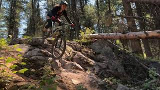
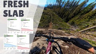
Built as a Rake and Ride this trail is a loamy single track with section of "choice your adventure". It will be changing as the ride line burns in, look before your leap. It has one of the largest, steepest rock slabs in the area, optional go around.

Tags
DropsLoamyRock gardensRock slabs

Local Trail Association

Recent Activity on Trail

Past Week
  • 0 rides
  •  
6 Months
  • 30 rides
  • 15 miles avg distance
All
  • 123 rides
  • Last: Nov 13, 2026
c1c2c3c4
January
February
March
April
May
June
July
August
September
October
November
December
update trails status or condition

Super Connected Trail Reports

statusdatedescription
Sep 28, 2026 @ 10:37am (America/Vancouver)
Sep 28, 2026
Perfect dirt on September 27. Amazing trail!
Aug 12, 2026 @ 1:11pm (America/Vancouver)
Aug 12, 2026
Legit Black Diamond. That slab is something else too.
Jul 9, 2026 @ 7:18am (America/Creston)
Jul 9, 2026
Beware the cow$hit as you enter the trees…..
Jul 7, 2026 @ 4:48pm (America/Vancouver)
Jul 7, 2026
May 27, 2026 @ 4:44am (America/Los_Angeles)
May 27, 2026
reporter Cleared all the blow down May 15th
more »
Status:
on Sep 28, 2026
Ideal
Avg: 3.99 (3 votes)
Your vote: 0

view (501)
close
      Directions to super-connected-468359 trailhead (50.171280, -119.231930)

      Photos

      24 more »
      mtb
      98 |
      May 4, 2026 @ 4:08pm
      May 4, 2026
      mtb
      124 |
      Nov 26, 2025 @ 1:53pm
      Nov 26, 2025
      mtb
      161 |
      Sep 17, 2025 @ 5:47pm
      Sep 17, 2025
      mtb
      157 |
      Sep 17, 2025 @ 5:47pm
      Sep 17, 2025

      Videos

      4 more »
      Familiar views in a new paradise!
      mtb
      26:52 | 168 | Aug 18, 2026 , Vernon
      40ft slab on new rake and ride trail
      mtb
      18:47 | 532 | Aug 8, 2025 , Vernon
      Super Connected
      mtb
      0:23 | | May 20, 2025 , Vernon
      Super Connected Slab
      mtb
      0:23 | | May 17, 2025 , Vernon
      4.0 ★★★★★
      3 Ratings
      5 ★ 33%
      4 ★ 33%
      3 ★ 33%
      2 ★
      1 ★

      3 Reviews & Comments

      cam-rides-bikes cam-rides-bikes
      Amazing trail, would ride again and again and again
      toizzz
      Had the pleasure of meeting the builders of this trail the day they finished raking it in.

      So we were the first riders down this trail!!!


      Great work guys!!!


      Some great rock drops and steep sections.

      Look for this trail to become quite popular as time goes on.

      We hope you've been enjoying Trailforks!

      Create a FREE account to view all trail reviews and much more.

      • By markeedTF Pro NOCS & contributors
      • #468359 - 2,320 views

      Frequently Asked Questions

      ▼ Where is Super Connected located?
      Super Connected is located in King Eddie Plateau, Vernon, British Columbia, Canada. It is part of the King Eddie Plateau trail network. The trailhead is located at coordinates 50.17128, -119.23193.
      ▼ How hard is Super Connected?
      Super Connected is rated as Black Diamond difficulty. The average grade is 11.1%.
      ▼ What is the elevation gain for Super Connected?
      Super Connected has 14 ft of elevation gain. The trail has 689 ft of elevation descent. The elevation ranges from 3,706 ft to 4,389 ft.
      ▼ Is Super Connected a point to point trail?
      Super Connected is not a point to point trail. The direction is Downhill Primary. The trail type is singletrack.
      ▼ How long is Super Connected?
      Super Connected is 1.1 miles long. The trail type is singletrack.
      ▼ Are dogs allowed on Super Connected?
      Yes, dogs are allowed on Super Connected. Please keep dogs on a leash where required and clean up after them.
      ▼ When is the best time of year to ride Super Connected?
      Based on activity log data, the most popular months to ride Super Connected are:
      • September (26 activities)
      • July (25 activities)
      • August (19 activities)
      Check the reports page for current trail conditions.
      ▼ How do I access Super Connected? Where is the closest parking trailhead?
      The closest parking and trailhead locations to Super Connected are: View all parking locations in the area.
      ▼ How long does it take to ride Super Connected?
      Based on recorded activities, it takes an average of 18 minutes to ride Super Connected. The trail is 1.1 miles long. Actual times will vary based on fitness level, conditions, and pace. View recent activity logs for more details.
      ▼ How busy is Super Connected?
      Super Connected is a very popular trail. There have been 500 recorded activities on this trail. The trail has received 501 check-ins. View recent activity on this trail.

      Hit the Trail

      Open in App

      Get this trail on your phone instantly.

      open trail in app

      Download Trail

      Save to wishlist, Garmin & download.
      save the trail

      Find Related Routes

      Find routes and users activities that include this trail.
      find routes for this trail

      You must enter a description before submitting.


