more stats
5,030 ft
Distance
16 ft
Climb
-641 ft
Descent
00:09:52
Avg time
-623 ft
Altitude change
955 ft
Altitude min
1,584 ft
Altitude max
1,581 ft
Altitude start
958 ft
Altitude end
-12.4%
Grade
-42%
Grade max
13.5%
Grade min
417 ft
Distance climb
4,035 ft
Distance down
581 ft
Distance flat
00:09:52
Avg time

Tacky Details

  • Activities
    • Mountain Bike
    • E-Bike
  • Riding Area
    Trnovica
    Rijeka
  • Difficulty Rating
  • Local Popularity
    85 in Mountain Biking [+]
    • 85 in E-Biking
  • Global Ranking
    #40033 in Mountain Biking [+]
    • #17287 in E-Biking
  • Trail Type
    Singletrack
  • Bike Type
    AM
  • Direction
    Downhill Only
    Popular Direction Shown
  • Season
    Feb - Dec
  • eBike Allowed
  • TTFs on Trail
    A-Frame, Berm, Bridge, Drop, Jump, Gap Jump, Ladder Bridge, Log Ride, Pump Track, Rock Face, Rock Garden, Roller Coaster, Skinny, Teeter Totter, Wallride, Other
  • Year Opened
    2017

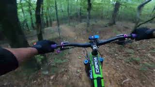
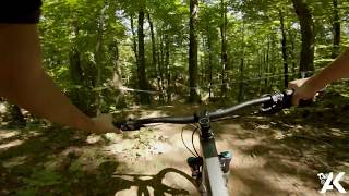
A third trail done by Team Rodeo very recently (March 2017). The trail is easier than Trn and Trnovo, but some say more fun. The trail also ends up in the Trn trail and then leads you to Carevo trail. It uses the same access trails as both of the aforementioned trails.

Trail is still developing but it is mostly done.

Access Info

Same access road from Sarsoni or from Trnovica.

Disclaimer

Ride smart, have fun.

Local Trail Association

Recent Activity on Trail

Past Week
  • 2 rides
  • 13 miles average
6 Months
  • 5 rides
  • 15 miles avg distance
All
  • 30 rides
  • Last: Jun 20, 2026
c1c2c3c4
January
February
March
April
May
June
July
August
September
October
November
December
Status:
on Aug 4, 2024
Ideal
Avg: 4.2 (9 votes)
Your vote: 0

view (814)
close
3D
Trail Conditions
  • Unknown
  • Snow Groomed
  • Snow Packed
  • Snow Covered
  • Snow Cover Partial
  • Freeze/thaw Cycle
  • Icy
  • Prevalent Mud
  • Wet
  • Variable
  • Ideal
  • Dry
  • Very Dry
Trail Flow (Ridden Direction)
Trailforks scans users ridelogs to determine the most popular direction each trail is ridden. A good flowing trail network will have most trails flowing in a single direction according to their intension.
The colour categories are based on what percentage of riders are riding a trail in its intended direction.
  • > 96%
  • > 90%
  • > 80%
  • > 70%
  • > 50%
  • < 50%
  • bi-directional trail
  • no data
Trail Last Ridden
Trailforks scans ridelogs to determine the last time a trail was ridden.
  • < 2 days
  • < 1 week
  • < 2 weeks
  • < 1 month
  • < 6 months
  • > 6 months
Trail Ridden Direction
The intended direction a trail should be ridden.
  • Downhill Only
  • Downhill Primary
  • Both Directions
  • Uphill Primary
  • Uphill Only
  • One Direction
Contribute Details
Colors indicate trail is missing specified detail.
  • Description
  • Photos
  • Description & Photos
  • Videos
Trail Popularity ?
Trailforks scans ridelogs to determine which trails are ridden the most in the last 9 months. Trails are compared with nearby trails in the same city region with a possible 25 colour shades. Think of this as a heatmap, more rides = more kinetic energy = warmer colors.
  • most popular
  • popular
  • less popular
  • not popular
ATV/ORV/OHV Filter
Max Vehicle Width
inches
US Cell Coverage
Legend
cell carrier legend

Radar Time
Activity Recordings
Trailforks uses anonymized public activity data. ?
Activity Recordings
Trailforks uses anonymized public activity data. ?
Personal Heatmap
Activity Types
all / none
Options
2
Date range month
Winter Trails
Warning A routing network for winter maps does not exist. Selecting trails using the winter trails layer has been disabled.
Missing Trails
Most Popular
Least Popular
Trails are colored based on popularity. The more popular a trail is, the more red. Less popular trails trend towards green.
Jump Magnitude Heatmap
Heatmap of where riders jump on trails. Zoom in to see individual jumps, click circles to view jump details.
BC Backroad Status

Service Road Atlas is a free to use, community-driven service for viewing and creating reports on the numerous back-country service roads around B.C. and Alberta.

map legend
Slope Aspect
Direction the slope faces
Flat N NE E SE S SW W NW
Trails Deemphasized
Trails are shown in grey.
disable
Only show trails with no bike usage.
Enable
Suggested Layers
Based on selected activity type

    Save the current map location and zoom level as your default home location whenever this page is loaded.

    Save
        Directions to tacky trailhead (45.386800, 14.419480)

        Photos

        15 more »
        181 |
        Jun 16, 2019 @ 9:30am
        Jun 16, 2019
        194 |
        Jun 16, 2019 @ 9:30am
        Jun 16, 2019
        145 |
        Jun 16, 2019 @ 9:30am
        Jun 16, 2019
        102 |
        Jun 16, 2019 @ 9:30am
        Jun 16, 2019

        Videos

        4 more »
        Tacky i Kačane noćna
        14:42 | 123 | Nov 9, 2022 , Rijeka
        Trnovica - Tacky
        7:04 | 245 | Sep 24, 2022 , Rijeka
        Trnovica sa ekipom iz Team Rodea
        12:43 | 145 | Mar 14, 2022 , Rijeka
        Tacky
        6:21 | 425 | Aug 14, 2019 , Rijeka

        Routes with this trail

        24 miles 3,390 ft 13 Loop
        My route from Matija to Tacky Brlog tails
        Trnduro 5 2019 Archived
        5.0 21 miles 2,743 ft 6 Race
        Race route of duro 5

        Reviews / Comments

        No reviews yet, be the first to write a review or ask a question.
        Use trail reports to comment on trail conditions.


        We hope you've been enjoying Trailforks!

        Create a FREE account to view trail comments and much more.

        Nearby Trails

        • By Archimonde & contributors
        • #85906 - 2,130 views

        Frequently Asked Questions About Tacky

        Where is Tacky located?
        Tacky is located in Trnovica, Rijeka, Croatia. It is part of the Trnovica trail network. The trailhead is located at coordinates 45.3868, 14.41948.
        How hard is Tacky?
        Tacky is rated as Red difficulty. The average grade is 12.4%.
        What is the elevation gain for Tacky?
        Tacky has 16 ft of elevation gain. The trail has 641 ft of elevation descent. The elevation ranges from 955 ft to 1,584 ft.
        Is Tacky a point to point trail?
        Yes, Tacky is a point to point trail. The direction is Downhill Only. The trail type is singletrack.

        Hit the Trail

        Open in App

        Get this trail on your phone instantly.
        open trail in app

        Download Trail

        Save to wishlist, Garmin & download.
        save the trail

        Find Related Routes

        Find routes and users activities that include this trail.
        find routes for this trail

        You must enter a description before submitting.