more stats
2,566 ft
Distance
-292 ft
Descent
00:01:52
Avg time
-291 ft
Altitude change
2,955 ft
Altitude min
3,247 ft
Altitude max
3,247 ft
Altitude start
2,956 ft
Altitude end
-11.3%
Grade
-23.7%
Grade max
0.5%
Grade min
128 ft
Distance climb
2,441 ft
Distance down
00:01:52
Avg time

Tea Trees Details

  • Activities
    • Mountain Bike
    • E-Bike
  • Riding Area
  • Difficulty Rating
  • Voted Difficulty
    Blue (1 vote)
  • Local Popularity
    80 in Mountain Biking [+]
    • 65 in E-Biking
  • Global Ranking
    #30643 in Mountain Biking [+]
    • #62775 in E-Biking
  • Trail Type
    Singletrack
  • Bike Type
    DH, AM, XC
  • Direction
    Downhill Primary
    Popular Direction Shown
  • Physical Rating
    Moderate
  • Trail Visibility
    Always easy to follow
  • eBike Allowed
    Yes up to Class 1
  • TTFs on Trail
    Berm, Jump
  • Land Owner
    MBP

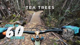
We considered calling this trail Paris Roubaix, and for good reason. Tea Trees is a rock armoured trail with steeper sections, which in some areas are like cobble stones. Find your flow and Tea Trees will reward you with a smooth (er) ride. Brake early for the board walks, particularly in the wet

Access Info

Access from Skyline

Bike Park

Local Trail Association
  • trail association logo
  • Please consider joining or donating to the local trail association to support
    trail development & maintenance.
Traditionally Indigenous Territory

Recent Activity on Trail

Past Week
  • 1 rides
  • 4 miles average
6 Months
  • 82 rides
  • 17 miles avg distance
All
  • 573 rides
  • Last: Jun 28, 2026
c1c2c3c4
January
February
March
April
May
June
July
August
September
October
November
December
update trails status or condition

Tea Trees Trail Reports

Status:
on Nov 16, 2024
Avg: 4.06 (9 votes)
Your vote: 0

view (5,936)
close
3D
Trail Conditions
  • Unknown
  • Snow Groomed
  • Snow Packed
  • Snow Covered
  • Snow Cover Partial
  • Freeze/thaw Cycle
  • Icy
  • Prevalent Mud
  • Wet
  • Variable
  • Ideal
  • Dry
  • Very Dry
Trail Flow (Ridden Direction)
Trailforks scans users ridelogs to determine the most popular direction each trail is ridden. A good flowing trail network will have most trails flowing in a single direction according to their intension.
The colour categories are based on what percentage of riders are riding a trail in its intended direction.
  • > 96%
  • > 90%
  • > 80%
  • > 70%
  • > 50%
  • < 50%
  • bi-directional trail
  • no data
Trail Last Ridden
Trailforks scans ridelogs to determine the last time a trail was ridden.
  • < 2 days
  • < 1 week
  • < 2 weeks
  • < 1 month
  • < 6 months
  • > 6 months
Trail Ridden Direction
The intended direction a trail should be ridden.
  • Downhill Only
  • Downhill Primary
  • Both Directions
  • Uphill Primary
  • Uphill Only
  • One Direction
Contribute Details
Colors indicate trail is missing specified detail.
  • Description
  • Photos
  • Description & Photos
  • Videos
Trail Popularity ?
Trailforks scans ridelogs to determine which trails are ridden the most in the last 9 months. Trails are compared with nearby trails in the same city region with a possible 25 colour shades. Think of this as a heatmap, more rides = more kinetic energy = warmer colors.
  • most popular
  • popular
  • less popular
  • not popular
ATV/ORV/OHV Filter
Max Vehicle Width
inches
US Cell Coverage
Legend
cell carrier legend

Radar Time
Activity Recordings
Trailforks uses anonymized public activity data. ?
Activity Recordings
Trailforks uses anonymized public activity data. ?
Personal Heatmap
Activity Types
all / none
Options
2
Date range month
Winter Trails
Warning A routing network for winter maps does not exist. Selecting trails using the winter trails layer has been disabled.
Missing Trails
Most Popular
Least Popular
Trails are colored based on popularity. The more popular a trail is, the more red. Less popular trails trend towards green.
Jump Magnitude Heatmap
Heatmap of where riders jump on trails. Zoom in to see individual jumps, click circles to view jump details.
BC Backroad Status

Service Road Atlas is a free to use, community-driven service for viewing and creating reports on the numerous back-country service roads around B.C. and Alberta.

map legend
Slope Aspect
Direction the slope faces
Flat N NE E SE S SW W NW
Trails Deemphasized
Trails are shown in grey.
disable
Only show trails with no bike usage.
Enable
Suggested Layers
Based on selected activity type

    Save the current map location and zoom level as your default home location whenever this page is loaded.

    Save
        Directions to tea-trees trailhead (-42.774030, 146.651810)

        Photos

        No photos have been added for Tea Trees yet, add a photo.

        Videos

        11 more »
        youtuber Tea Trees  \\  Maydena Bike Park
        3:07 | 235 | Apr 2, 2023 , Maydena
        Wet, Rocky, Relentless
        0:09 | 2 | Jun 14, 2026 , Maydena
        Mayden Bike Park - Intermediate Trails - Flowy...
        55 | Jan 19, 2025 , Maydena
        youtuber Our first lap down Maydena Bikepark! |...
        22:44 | 151 | Jun 4, 2024 , Maydena

        Trail Lists

        1 Review & Comments


        We hope you've been enjoying Trailforks!

        Create a FREE account to view trail comments and much more.

        • By mjjrTF Pro & contributors
        • #134775 - 1,326 views

        Frequently Asked Questions About Tea Trees

        Where is Tea Trees located?
        Tea Trees is located in Maydena Bike Park, Maydena, Australia. It is part of the Maydena Bike Park trail network. The trailhead is located at coordinates -42.77403, 146.65181.
        How hard is Tea Trees?
        Tea Trees is rated as Blue difficulty. The physical rating is Moderate. The average grade is 11.3%.
        What is the elevation gain for Tea Trees?
        The trail has 292 ft of elevation descent. The elevation ranges from 2,955 ft to 3,247 ft.
        Is Tea Trees a point to point trail?
        Tea Trees is not a point to point trail. The direction is Downhill Primary. The trail type is singletrack.

        Hit the Trail

        Open in App

        Get this trail on your phone instantly.
        open trail in app

        Download Trail

        Save to wishlist, Garmin & download.
        save the trail

        Find Related Routes

        Find routes and users activities that include this trail.
        find routes for this trail

        You must enter a description before submitting.