361 ft
Distance
-58 ft
Descent
00:01:04
Avg time

Tech Noir Details

  • Activities
    • Mountain Bike
  • Riding Area
    Whistler Mountain Bike Park
    Whistler, British Columbia
  • Difficulty Rating
  • Voted Difficulty
    Black Diamond (3 votes)
  • Trail Type
    Singletrack
  • Bike Type
    DH, AM
  • Direction
    Downhill Only
    Popular direction shown
  • TTFs on Trail
    Rock Face
  • Global Ranking
    #180 in Mountain Biking
  • Local Popularity
    20 in Mountain Biking
  • Land Owner

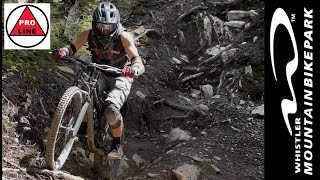
Tech Noir is an intense two-hit trail for expert riders that splits off of Afternoon Delight. Things get started with a rutted groove that feeds into an unforgiving jagged rock-roll with barely any run out. From there, a section of off-camber roots rolls into the Tech Noir's rock-roll exit. Although the roll itself isn't overtly more difficult than other big rock-rolls on the mountain, the run-out is loaded with plenty of jagged rocks that require commitment and handling.

Bike Park

More Stats for Tech Noir mountain bike trail trail
  • Altitude change
    -58 ft
  • Altitude min
    2,619 ft
  • Altitude max
    2,677 ft
  • Altitude start
    2,677 ft
  • Altitude end
    2,618 ft
  • Grade
    -16.1%
  • Grade max
    -35.9%
  • Distance down
    305 ft
  • Distance flat
    56 ft
  • Avg time
    00:01:04
  • Avg reverse time
    00:01:29
  • view trail stats
Status:
on Oct 25, 2024
Avg: 4.17 (36 votes)
Your vote: 0

view (10,690)
close
3D
Trail Conditions
  • Unknown
  • Snow Groomed
  • Snow Packed
  • Snow Covered
  • Snow Cover Partial
  • Freeze/thaw Cycle
  • Icy
  • Prevalent Mud
  • Wet
  • Variable
  • Ideal
  • Dry
  • Very Dry
Trail Flow (Ridden Direction)
Trailforks scans users ridelogs to determine the most popular direction each trail is ridden. A good flowing trail network will have most trails flowing in a single direction according to their intension.
The colour categories are based on what percentage of riders are riding a trail in its intended direction.
  • > 96%
  • > 90%
  • > 80%
  • > 70%
  • > 50%
  • < 50%
  • bi-directional trail
  • no data
Trail Last Ridden
Trailforks scans ridelogs to determine the last time a trail was ridden.
  • < 2 days
  • < 1 week
  • < 2 weeks
  • < 1 month
  • < 6 months
  • > 6 months
Trail Ridden Direction
The intended direction a trail should be ridden.
  • Downhill Only
  • Downhill Primary
  • Both Directions
  • Uphill Primary
  • Uphill Only
  • One Direction
Contribute Details
Colors indicate trail is missing specified detail.
  • Description
  • Photos
  • Description & Photos
  • Videos
Trail Popularity ?
Trailforks scans ridelogs to determine which trails are ridden the most in the last 9 months. Trails are compared with nearby trails in the same city region with a possible 25 colour shades. Think of this as a heatmap, more rides = more kinetic energy = warmer colors.
  • most popular
  • popular
  • less popular
  • not popular
ATV/ORV/OHV Filter
Max Vehicle Width
inches
US Cell Coverage
Legend
cell carrier legend

Radar Time
x Activity Recordings
Trailforks users anonymized public ridelogs from the past 6 months.
  • mountain biking recent
  • mountain biking (>6 month)
  • hiking (1 year)
  • moto (1 year)
Activity Recordings
Trailforks users anonymized public skilogs from the past 12 months.
  • Downhill Ski
  • Backcountry Ski
  • Nordic Ski
  • Snowmobile
Winter Trails
Warning A routing network for winter maps does not exist. Selecting trails using the winter trails layer has been disabled.
x Missing Trails
Most Popular
Least Popular
Trails are colored based on popularity. The more popular a trail is, the more red. Less popular trails trend towards green.
Jump Magnitude Heatmap
Heatmap of where riders jump on trails. Zoom in to see individual jumps, click circles to view jump details.
Trails Deemphasized
Trails are shown in grey.
disable
Only show trails with NO bikes.
enable

Save the current map location and zoom level as your default home location whenever this page is loaded.

Save
      Directions to tech-noir trailhead (50.107280, -122.956650)
      update trails status or condition

      Tech Noir Trail Reports

      Recent Ridelog Activity on Trail

      Past Week
      • 0 rides
      •  
      6 Months
      • 14 rides
      • 31 miles avg distance
      All
      • 1,056 rides
      • Last: Jun 11, 2024

      Photos

      more »
      377 |
      Jul 23, 2015 @ 7:59pm
      Jul 23, 2015
      609 |
      Oct 28, 2014 @ 9:33pm
      Oct 28, 2014
      631 |
      Oct 28, 2014 @ 9:33pm
      Oct 28, 2014

      Trail Lists

      Trail Products

      Reviews / Comments

      No reviews yet, be the first to write a review or ask a question.
      Use trail reports to comment on trail conditions.


      We hope you've been enjoying Trailforks!

      Create a FREE account to view trail comments and much more.

      Videos

      more »
      youtuber Short Double Black Trails in the Whistler Bike...
      4:04 | 899 | Jul 16, 2018 , Whistler
      youtuber Riding Double Black Trails at 57?  Tech Noir...
      3:17 | 739 | May 20, 2019 , Whistler
      youtuber 13 of Whistler's Funnest Tech Trails -...
      18:59 | 78 | Feb 14, 2024 , Whistler
      youtuber Putting That Skill To Use On Double Black Tech...
      3:08 | 67 | Sep 24, 2023 , Whistler

      You must enter a description before submitting.