more stats
1,775 ft
Distance
-453 ft
Descent
00:03:45
Avg time
-453 ft
Altitude change
4,480 ft
Altitude min
4,933 ft
Altitude max
4,933 ft
Altitude start
4,482 ft
Altitude end
-25.5%
Grade
-66.3%
Grade max
-7%
Grade min
1,775 ft
Distance down
00:03:45
Avg time

Tejo Deep Details

  • Activities
    • Mountain Bike
    • E-Bike
    • Hike
    • Trail Running
  • Riding Area
    La Jarosa
    Guadarrama
  • Difficulty Rating
  • Local Popularity
    85 in Mountain Biking [+]
    • 90 in E-Biking
    • 5 in Trail Running
    • 5 in Hiking
  • Global Ranking
    #8121 in Mountain Biking [+]
    • #23324 in E-Biking
    • #134788 in Trail Running
    • #128390 in Hiking
  • Hiking SAC Scale
    T1 Hiking
  • Trail Exposure
    Normal
  • Trail Type
    Singletrack
  • Bike Type
    DH, AM
  • Direction
    Downhill Primary
    Popular Direction Shown
  • Physical Rating
    Hard
  • Trail Visibility
    Always easy to follow
  • Dogs Allowed
    Yes
  • eBike Allowed
    Yes up to Class 1
  • TTFs on Trail
    Berm, Drop, Jump, Gap Jump

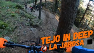
Sendero con mucha inclinación, curvas cerradas y peraltes en un terreno de tierra suelta ideal. Muy divertido, pero necesitas buen estado físico y una buena técnica para mantener la velocidad y no romper el trabajo de los builders locales frenando demasiado en los peraltes para mantener la velocidad. Algunas secciones tienen una doble linea para adelantar a tus compañeros si te sientes juguetón

Very steep, technical trail with tight corners and berms in a loamy dirt terrain. Super fun but you need a good skillset and good physical condition to ride smoothly down the slope and not destroy the local trailbuilder´s work dragging your brakes trough the berms to slow down in the steepest parts. Some sections have a double line to overtake your riding buddies if you feel cheeky!

Recent Activity on Trail

Past Week
  • 0 rides
  •  
6 Months
  • 26 rides
  • 16 miles avg distance
All
  • 84 rides
  • Last: Jun 13, 2026
c1c2c3c4
January
February
March
April
May
June
July
August
September
October
November
December
update trails status or condition

Tejo Deep Trail Reports

statusdatedescription
May 17, 2026 @ 5:33pm (Europe/Madrid)
May 17, 2026
Apr 19, 2026 @ 4:02pm (Europe/Madrid)
Apr 19, 2026
Apr 2, 2026 @ 9:15pm (Europe/Madrid)
Apr 2, 2026
Dec 8, 2025 @ 10:38am (Europe/Madrid)
Dec 8, 2025
Sep 8, 2024 @ 10:09am
Sep 8, 2024
Primera mitad en condiciones, segunda mitad muy deteriorada con multiples trazadas todas reventadas, atajos, roderas de bajar derrapando muy...
more »
Status:
on May 17, 2026
Ideal
Avg: 4.21 (3 votes)
Your vote: 0

view (934)
close
3D
Trail Conditions
  • Unknown
  • Snow Groomed
  • Snow Packed
  • Snow Covered
  • Snow Cover Partial
  • Freeze/thaw Cycle
  • Icy
  • Prevalent Mud
  • Wet
  • Variable
  • Ideal
  • Dry
  • Very Dry
Trail Flow (Ridden Direction)
Trailforks scans users ridelogs to determine the most popular direction each trail is ridden. A good flowing trail network will have most trails flowing in a single direction according to their intension.
The colour categories are based on what percentage of riders are riding a trail in its intended direction.
  • > 96%
  • > 90%
  • > 80%
  • > 70%
  • > 50%
  • < 50%
  • bi-directional trail
  • no data
Trail Last Ridden
Trailforks scans ridelogs to determine the last time a trail was ridden.
  • < 2 days
  • < 1 week
  • < 2 weeks
  • < 1 month
  • < 6 months
  • > 6 months
Trail Ridden Direction
The intended direction a trail should be ridden.
  • Downhill Only
  • Downhill Primary
  • Both Directions
  • Uphill Primary
  • Uphill Only
  • One Direction
Contribute Details
Colors indicate trail is missing specified detail.
  • Description
  • Photos
  • Description & Photos
  • Videos
Trail Popularity ?
Trailforks scans ridelogs to determine which trails are ridden the most in the last 9 months. Trails are compared with nearby trails in the same city region with a possible 25 colour shades. Think of this as a heatmap, more rides = more kinetic energy = warmer colors.
  • most popular
  • popular
  • less popular
  • not popular
ATV/ORV/OHV Filter
Max Vehicle Width
inches
US Cell Coverage
Legend
cell carrier legend

Radar Time
Activity Recordings
Trailforks uses anonymized public activity data. ?
Activity Recordings
Trailforks uses anonymized public activity data. ?
Personal Heatmap
Activity Types
all / none
Options
2
Date range month
Winter Trails
Warning A routing network for winter maps does not exist. Selecting trails using the winter trails layer has been disabled.
Missing Trails
Most Popular
Least Popular
Trails are colored based on popularity. The more popular a trail is, the more red. Less popular trails trend towards green.
Jump Magnitude Heatmap
Heatmap of where riders jump on trails. Zoom in to see individual jumps, click circles to view jump details.
BC Backroad Status

Service Road Atlas is a free to use, community-driven service for viewing and creating reports on the numerous back-country service roads around B.C. and Alberta.

map legend
Slope Aspect
Direction the slope faces
Flat N NE E SE S SW W NW
Trails Deemphasized
Trails are shown in grey.
disable
Only show trails with no bike usage.
Enable
Suggested Layers
Based on selected activity type

    Save the current map location and zoom level as your default home location whenever this page is loaded.

    Save
        Directions to tejo-deep trailhead (40.695650, -4.138230)

        Photos

        No photos have been added for Tejo Deep yet, add a photo.

        Videos

        1 more »
        youtuber ⛰ Tejo in Deep ◾️ | La Jarosa |...
        5:32 | 171 | Jan 4, 2024 , Guadarrama

        1 Review & Comments


        We hope you've been enjoying Trailforks!

        Create a FREE account to view trail comments and much more.

        • By not-reallyTF Pro TFSPAIN & contributors
        • #504266 - 555 views

        Frequently Asked Questions About Tejo Deep

        Where is Tejo Deep located?
        Tejo Deep is located in La Jarosa, Guadarrama, Spain. It is part of the La Jarosa trail network. The trailhead is located at coordinates 40.69565, -4.13823.
        How hard is Tejo Deep?
        Tejo Deep is rated as Black difficulty. The physical rating is Hard. The average grade is 25.5%.
        What is the elevation gain for Tejo Deep?
        The trail has 453 ft of elevation descent. The elevation ranges from 4,480 ft to 4,933 ft.
        Is Tejo Deep a point to point trail?
        Tejo Deep is not a point to point trail. The direction is Downhill Primary. The trail type is singletrack.

        Hit the Trail

        Open in App

        Get this trail on your phone instantly.
        open trail in app

        Download Trail

        Save to wishlist, Garmin & download.
        save the trail

        Find Related Routes

        Find routes and users activities that include this trail.
        find routes for this trail

        You must enter a description before submitting.