

Open in App
Get this trail on your phone instantly.

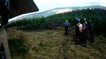
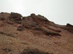
The tempo changes dramatically as you start the testing climb on the other side of the river crossing. There’s no chance of carrying speed here, as it starts steep and rocky with some very tight turns. Things ease slightly in the middle section, before a final steep snap leads you gasping out onto the open hill. There’s some respite downhill before a better chance to recover (and regroup) for a short spell on contouring forest road.
Part of Ae red route (Ae Line)
| c1 | c2 | c3 | c4 |
|---|---|---|---|
January | February | March | April |
May | June | July | August |
September | October | November | December |

Service Road Atlas is a free to use, community-driven service for viewing and creating reports on the numerous back-country service roads around B.C. and Alberta.
Save the current map location and zoom level as your default home location whenever this page is loaded.
SaveWe hope you've been enjoying Trailforks!
Create a FREE account to view trail comments and much more.
You must enter a description before submitting.

