more stats
1.4 miles
Distance
17 ft
Climb
-1,150 ft
Descent
00:11:37
Avg time
-1,133 ft
Altitude change
997 ft
Altitude min
2,130 ft
Altitude max
2,130 ft
Altitude start
997 ft
Altitude end
-15.207%
Grade
-54.945%
Grade max
6.907%
Grade min
280 ft
Distance climb
1 mile
Distance down
243 ft
Distance flat
00:11:37
Avg time

The Fuzz Details

  • Activities
    • Mountain Bike
    • E-Bike
  • Riding Area
  • AKA
    Crankworx DH
  • Difficulty Rating
  • Local Popularity
    15 in Mountain Biking heatmap [+]
    • 5 in E-Biking
  • Global Ranking
    #130250 in Mountain Biking [+]
    • #142273 in E-Biking
  • National Ranking
    #2,967 in Mountain Biking · New Zealand [+]
    • #2,615 in E-Biking
  • Trail Type
    Singletrack
  • Bike Type
    DH
  • Direction
    Downhill Primary
  • Dogs Allowed
    Yes
  • eBike Allowed
    Yes up to Class 1
  • TTFs on Trail
    A-Frame, Bridge, Drop, Jump

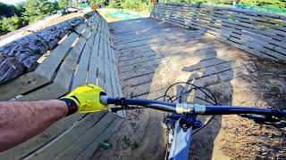
Think you’re up to riding a World Cup level DH track? Well this is your opportunity. The Fuzz is a tip of the hat to a local legend and the Skyline section of the Downhill line used for Crankworx 2015 and 2016. It leads almost immediately into a rock garden and bridges. The bridges have very steep descents off them with a rock garden between them. The rest of the track is fast and open with features. The Fuzz finishes with a steep off camber section under the gondola line, so you will always have spectators.

Access Info

The lower half of the course is run at Skyline and is accessed through the park. Upper sections of the course are not available to ride day to day.

Trail Supporters

Bike Park

Recent Activity on Trail

Past Week
  • 0 rides
  •  
6 Months
  • 0 rides
  •  
All
  • 1 rides
  • Last: Mar 14, 2026
c1c2c3c4
January
February
March
April
May
June
July
August
September
October
November
December
update trails status or condition

The Fuzz Trail Reports

no reports have been added for The Fuzz yet, add a trail report.
Trail reports are used to indicate a trails current condition and inform builders and other users about any issues on a trail.
Status:
Avg: 4.16 (6 votes)
Your vote: 0

view (15)
close
      Directions to the-fuzz trailhead (-38.113820, 176.198390)

      Photos

      254 more »
      mtb
      361 |
      Nov 11, 2022 @ 4:09pm
      Nov 11, 2022
      mtb
      253 |
      Nov 11, 2022 @ 4:09pm
      Nov 11, 2022
      mtb
      269 |
      Nov 11, 2022 @ 4:09pm
      Nov 11, 2022
      mtb
      138 |
      Nov 11, 2022 @ 4:09pm
      Nov 11, 2022

      Videos

      13 more »
      youtuber The Fuzz @ Skyline Rotorua
      mtb
      2:23 | 1362 | May 27, 2020 , Rotorua
      JONTY VINK VS CRANKWORX ROTORUA
      mtb
      2:35 | 312 | Mar 25, 2019 , Rotorua
      Big ol crash on crankworx rotorua dh step up
      mtb
      0:10 | 2458 | Jan 25, 2017 , Rotorua
      Crankworx Rotorua 2016 | Beyond The Bikes
      mtb
      4:59 | 171 | Jul 14, 2016 , Rotorua

      Routes with this trail

      more »
      1 mile • 6 • Point to Point • Race •
      Downhill course for the Secondary Schools DH at Crankworx
      ★ 5.0 • 4,147 ft • 230 ft • 5 • Loop • Race •
      Proposed course for the NZ secondary schools XC relay
      4.4 ★★★★★
      6 Ratings
      5 ★ 67%
      4 ★ 17%
      3 ★
      2 ★ 17%
      1 ★

      2 Reviews & Comments

      ncipperly
      Why is this listed as a blue. Shouldn't it be a Grade 6 Black?

      We hope you've been enjoying Trailforks!

      Create a FREE account to view all trail reviews and much more.

      Frequently Asked Questions

      ▼ Where is The Fuzz located?
      The Fuzz is located in Skyline - Rotorua, Rotorua, New Zealand. It is part of the Skyline - Rotorua trail network. The trailhead is located at coordinates -38.11382, 176.19839.
      ▼ How hard is The Fuzz?
      The Fuzz is rated as Double Black Diamond difficulty. The average grade is 15.207%.
      ▼ What is the elevation gain for The Fuzz?
      The Fuzz has 17 ft of elevation gain. The trail has 1,150 ft of elevation descent. The elevation ranges from 997 ft to 2,130 ft.
      ▼ Is The Fuzz a point to point trail?
      The Fuzz is not a point to point trail. The direction is Downhill Primary. The trail type is singletrack.
      ▼ How long is The Fuzz?
      The Fuzz is 1.4 miles long. The trail type is singletrack.
      ▼ Are dogs allowed on The Fuzz?
      Yes, dogs are allowed on The Fuzz. Please keep dogs on a leash where required and clean up after them.
      ▼ When is the best time of year to ride The Fuzz?
      Based on activity log data, the most popular months to ride The Fuzz are:
      • January (1 activities)
      Check the reports page for current trail conditions.
      ▼ How do I access The Fuzz? Where is the closest parking trailhead?
      The closest parking and trailhead locations to The Fuzz are: View all parking locations in the area.
      ▼ How long does it take to ride The Fuzz?
      The estimated time to ride The Fuzz is approximately 12 minutes. The trail is 1.4 miles long. Actual times will vary based on fitness level, conditions, and pace.
      ▼ How busy is The Fuzz?
      The Fuzz is a less popular trail with lighter traffic. There have been 12 recorded activities on this trail. The trail has received 15 check-ins. View recent activity on this trail.

      Hit the Trail

      Open in App

      Get this trail on your phone instantly.

      open trail in app

      Download Trail

      Save to wishlist, Garmin & download.
      save the trail

      Find Related Routes

      Find routes and users activities that include this trail.
      find routes for this trail

      You must enter a description before submitting.