


more stats
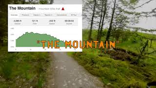
4,062 ft
Distance
121 ft
Climb
-242 ft
Descent
00:09:39
Avg time
-121 ft
Altitude change
997 ft
Altitude min
1,233 ft
Altitude max
1,119 ft
Altitude start
997 ft
Altitude end
-3%
Grade
-35.2%
Grade max
22.3%
Grade min
1,043 ft
Distance climb
2,441 ft
Distance down
525 ft
Distance flat
00:09:39
Avg time

The Mountain Details

  • Activities
    • Mountain Bike
    • E-Bike
  • Riding Area
    Gortin Glen
    Omagh
  • Difficulty Rating
  • Local Popularity
    35 in Mountain Biking [+]
    • 35 in E-Biking
  • Global Ranking
    #27302 in Mountain Biking [+]
    • #80342 in E-Biking
  • Trail Type
    Machine Groomed
  • Bike Type
    AM, XC
  • Direction
    One Direction
    Popular Direction Shown
  • Climb Difficulty
    Green
  • Physical Rating
    Moderate
  • Trail Visibility
    Always easy to follow
  • eBike Allowed
    Yes up to Class 1
  • TTFs on Trail
    Berm, Drop, Rock Garden
  • Ride in Rain
    Yes
  • Year Opened
    2020
  • Land Owner
    Fermanagh and Omagh District Council

The Mountain is a red grade trail. The first part of the trail is a climbing section followed by a flat "whoop" section before pointing downhill for the remainder of the trail for some rock steps and tight technical turns. berms and rollers are present on this trail.

Access Info

Access to The Mountain can be gained via the official forest road and mullaghcarn road from the car park, or via the scenic drive.

Local Trail Association

Recent Activity on Trail

Past Week
  • 1 rides
  • 16 miles average
6 Months
  • 8 rides
  • 14 miles avg distance
All
  • 52 rides
  • Last: Sep 20, 2026
c1c2c3c4
January
February
March
April
May
June
July
August
September
October
November
December
update trails status or condition

The Mountain Trail Reports

statusdatedescription
Feb 17, 2026 @ 1:50pm (Europe/London)
Feb 17, 2026
Running well, a few frozen puddles (was a frosty day though) in places but great condition, particularly after all the recent storms.
May 19, 2025 @ 4:32pm
May 19, 2025
May 2, 2025 @ 3:27pm
May 2, 2025
Officially still closed I think but not really for any reason other than a few fallen trees right next to the trail. All rideable and no need to...
Mar 29, 2025 @ 11:30am
Mar 29, 2025
CLOSED, but trail is cleared and doesn't need any hopping off. A few tree roots pulled up beside the trail but all passable
Mar 13, 2025 @ 7:18am
Mar 13, 2025
Only Kelan's climb and Kelan's descent were open 12/03/2025 (along with the forest road from the car park to access Kelan's climb). ALL other...
more »
Status:
on Feb 17, 2026
Wet
Avg: 3.86 (2 votes)
Your vote: 0

view (780)
close
      Directions to the-mountain trailhead (54.685650, -7.227910)

      Photos

      3 more »
      mtb
      57 |
      Jul 13, 2021 @ 5:10am
      Jul 13, 2021
      mtb
      80 |
      Jul 13, 2021 @ 5:09am
      Jul 13, 2021
      report
      mtb
      32 |
      Mar 13, 2025 @ 7:21am
      Mar 13, 2025

      Videos

      4 more »
      The Mountain and Sikas run
      mtb
      9:24 | 168 | Mar 20, 2022 , Omagh
      Descent from the Mountain climb
      mtb
      2:58 | 466 | Sep 20, 2021 , Omagh
      Gortin The Mountain
      mtb
      2:51 | 251 | Jul 15, 2021 , Omagh
      MountainBikeNI.com - MTB Trails Northern Ireland
      mtb
      4:16 | 5368 | Mar 20, 2014 , Omagh

      Routes with this trail

      10 miles • 1,992 ft • 38 • Loop •
      This route follows the official forest roads to guide users to all the official trails in the Gortin Glens...
      ★ 5.0 • 10 miles • 1,976 ft • 13 • Loop • Race •
      Race course for the Vitus First Track Cup Gortin Glen 2021
      3.5 ★★★★★
      2 Ratings
      5 ★
      4 ★ 50%
      3 ★ 50%
      2 ★
      1 ★

      Reviews / Comments

      No reviews yet, be the first to write a review or ask a question.
      Use trail reports to comment on trail conditions.


      We hope you've been enjoying Trailforks!

      Create a FREE account to view all trail reviews and much more.

      • By Leek9 & contributors
      • #383875 - 801 views

      Frequently Asked Questions

      ▼ Where is The Mountain located?
      The Mountain is located in Gortin Glen, Omagh, United Kingdom. It is part of the Gortin Glen trail network. The trailhead is located at coordinates 54.68565, -7.22791.
      ▼ How hard is The Mountain?
      The Mountain is rated as Red difficulty. The physical rating is Moderate. The average grade is 3%. The climb difficulty is rated Green.
      ▼ What is the elevation gain for The Mountain?
      The Mountain has 121 ft of elevation gain. The trail has 242 ft of elevation descent. The elevation ranges from 997 ft to 1,233 ft.
      ▼ Is The Mountain a point to point trail?
      Yes, The Mountain is a point to point trail. The direction is One Direction. The trail type is machine groomed.
      ▼ How long is The Mountain?
      The Mountain is 4,062 ft long. The trail type is machine groomed.
      ▼ Are dogs allowed on The Mountain?
      There is no information about dogs being allowed on The Mountain. Check with local trail managers or the trail page for the latest access rules.
      ▼ How do I access The Mountain? Where is the closest parking trailhead?
      The closest parking and trailhead locations to The Mountain are: View all parking locations in the area.
      ▼ How long does it take to ride The Mountain?
      Based on recorded activities, it takes an average of 10 minutes to ride The Mountain. The trail is 4,062 ft long. Actual times will vary based on fitness level, conditions, and pace. View recent activity logs for more details.
      ▼ How busy is The Mountain?
      The Mountain is a less popular trail with lighter traffic. There have been 728 recorded activities on this trail. The trail has received 780 check-ins. View recent activity on this trail.

      Hit the Trail

      Open in App

      Get this trail on your phone instantly.

      open trail in app

      Download Trail

      Save to wishlist, Garmin & download.
      save the trail

      Find Related Routes

      Find routes and users activities that include this trail.
      find routes for this trail

      You must enter a description before submitting.



