more stats
7.0 miles
Distance
833 ft
Climb
-826 ft
Descent
00:52:16
Avg time
7 ft
Altitude change
1,725 ft
Altitude min
2,094 ft
Altitude max
1,763 ft
Altitude start
1,772 ft
Altitude end
-24.7%
Grade max
20.9%
Grade min
3 miles
Distance climb
3 miles
Distance down
2 miles
Distance flat
00:52:16
Avg time

Thompson Loop-CCW Details

  • Activities
    • Mountain Bike
    • Horse
    • Hike
    • Trail Running
  • Riding Area
    Tsali Recreation Area
    Bryson City, North Carolina
  • Difficulty Rating
  • Local Popularity
    95 in Mountain Biking [+]
    • 95 in Trail Running
    • 80 in Hiking
    • 5 in Horseback
  • Global Ranking
    #60993 in Mountain Biking [+]
    • #22084 in Trail Running
    • #51778 in Hiking
  • Trail Type
    Singletrack
  • Bike Type
    AM, XC
  • Dogs Allowed
    Yes
  • eBike Allowed
  • Land Owner
    Nantahala NF, Cheoah Ranger District

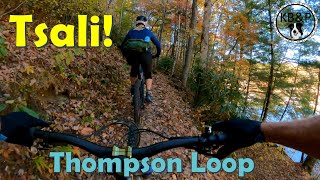
Some stream crossings and old logging roads. Mixed pine and hardwood forests at Tsali are easily recognized on this trail. Some old homesites. Neat part of forest with tall hemlocks and rhododendron, not typical of the heavily logged areas at Tsali. More great lakeshore singletrack riding with long, gradual hills. Some really great fast gravel road sections.

Trail Supporters

  • USFS
    Land Manager

Recent Activity on Trail

Past Week
  • 1 rides
  • 13.4 km average
6 Months
  • 30 rides
  • 20.4 km avg distance
All
  • 290 rides
  • Last: Jun 27, 2026
c1c2c3c4
January
February
March
April
May
June
July
August
September
October
November
December
Status:
on Jun 18, 2026
Ideal
Avg: 4.05 (11 votes)
Your vote: 0

view (1,592)
close
3D
Trail Conditions
  • Unknown
  • Snow Groomed
  • Snow Packed
  • Snow Covered
  • Snow Cover Partial
  • Freeze/thaw Cycle
  • Icy
  • Prevalent Mud
  • Wet
  • Variable
  • Ideal
  • Dry
  • Very Dry
Trail Flow (Ridden Direction)
Trailforks scans users ridelogs to determine the most popular direction each trail is ridden. A good flowing trail network will have most trails flowing in a single direction according to their intension.
The colour categories are based on what percentage of riders are riding a trail in its intended direction.
  • > 96%
  • > 90%
  • > 80%
  • > 70%
  • > 50%
  • < 50%
  • bi-directional trail
  • no data
Trail Last Ridden
Trailforks scans ridelogs to determine the last time a trail was ridden.
  • < 2 days
  • < 1 week
  • < 2 weeks
  • < 1 month
  • < 6 months
  • > 6 months
Trail Ridden Direction
The intended direction a trail should be ridden.
  • Downhill Only
  • Downhill Primary
  • Both Directions
  • Uphill Primary
  • Uphill Only
  • One Direction
Contribute Details
Colors indicate trail is missing specified detail.
  • Description
  • Photos
  • Description & Photos
  • Videos
Trail Popularity ?
Trailforks scans ridelogs to determine which trails are ridden the most in the last 9 months. Trails are compared with nearby trails in the same city region with a possible 25 colour shades. Think of this as a heatmap, more rides = more kinetic energy = warmer colors.
  • most popular
  • popular
  • less popular
  • not popular
ATV/ORV/OHV Filter
Max Vehicle Width
inches
US Cell Coverage
Legend
cell carrier legend

Radar Time
Activity Recordings
Trailforks uses anonymized public activity data. ?
Activity Recordings
Trailforks uses anonymized public activity data. ?
Personal Heatmap
Activity Types
all / none
Options
2
Date range month
Winter Trails
Warning A routing network for winter maps does not exist. Selecting trails using the winter trails layer has been disabled.
Missing Trails
Most Popular
Least Popular
Trails are colored based on popularity. The more popular a trail is, the more red. Less popular trails trend towards green.
Jump Magnitude Heatmap
Heatmap of where riders jump on trails. Zoom in to see individual jumps, click circles to view jump details.
BC Backroad Status

Service Road Atlas is a free to use, community-driven service for viewing and creating reports on the numerous back-country service roads around B.C. and Alberta.

map legend
Slope Aspect
Direction the slope faces
Flat N NE E SE S SW W NW
Trails Deemphasized
Trails are shown in grey.
disable
Only show trails with no bike usage.
Enable
Suggested Layers
Based on selected activity type

    Save the current map location and zoom level as your default home location whenever this page is loaded.

    Save
        Directions to thompson-loopccw trailhead (35.405530, -83.586940)

        Photos

        5 more »
        86 |
        Sep 30, 2024 @ 7:12pm
        Sep 30, 2024
        206 |
        Dec 7, 2021 @ 3:45pm
        Dec 7, 2021
        328 |
        Oct 28, 2017 @ 3:45am
        Oct 28, 2017
        397 |
        Nov 21, 2016 @ 11:14am
        Nov 21, 2016

        Videos

        1 more »
        youtuber Biking the Thompson Loop at Tsali in the Fall!
        6:21 | 461 | Nov 5, 2022 , Bryson City

        2 Reviews & Comments


        We hope you've been enjoying Trailforks!

        Create a FREE account to view trail comments and much more.

        Frequently Asked Questions About Thompson Loop-CCW

        Where is Thompson Loop-CCW located?
        Thompson Loop-CCW is located in Tsali Recreation Area, Bryson City, North Carolina, United States. It is part of the Tsali Recreation Area trail network. The trailhead is located at coordinates 35.40553, -83.58694.
        How hard is Thompson Loop-CCW?
        Thompson Loop-CCW is rated as Blue difficulty.
        What is the elevation gain for Thompson Loop-CCW?
        Thompson Loop-CCW has 833 ft of elevation gain. The trail has 826 ft of elevation descent. The elevation ranges from 1,725 ft to 2,094 ft.
        How long is Thompson Loop-CCW?
        Thompson Loop-CCW is 7.0 miles long. The trail type is singletrack.

        Hit the Trail

        Open in App

        Get this trail on your phone instantly.
        open trail in app

        Download Trail

        Save to wishlist, Garmin & download.
        save the trail

        Find Related Routes

        Find routes and users activities that include this trail.
        find routes for this trail

        You must enter a description before submitting.