more stats
2.5 miles
Distance
3 ft
Climb
-1,385 ft
Descent
00:20:12
Avg time
-1,382 ft
Altitude change
6,707 ft
Altitude min
8,090 ft
Altitude max
8,090 ft
Altitude start
6,706 ft
Altitude end
-10.3%
Grade
-43.7%
Grade max
4.3%
Grade min
299 ft
Distance climb
2 miles
Distance down
354 ft
Distance flat
00:20:12
Avg time

Tibble Fork, Upper Details

  • Activities
    • Mountain Bike
    • E-Bike
    • Horse
    • Hike
    • Trail Running
    • Dirtbike/Moto
  • Riding Area
    American Fork Canyon
    Cedar Hills, Utah
  • Ref Number
    #041
  • Difficulty Rating
  • Local Popularity
    85 in Mountain Biking [+]
    • 90 in E-Biking
    • 50 in Trail Running
    • 60 in Hiking
    • 90 in Dirtbiking
    • 5 in Horseback
  • Global Ranking
    #31802 in Mountain Biking [+]
    • #2697 in E-Biking
    • #73097 in Trail Running
    • #62719 in Hiking
    • #93 in Dirtbiking
    • #940 in Horseback
  • Hiking SAC Scale
    T2 Mountain Hiking
  • Trail Type
    Singletrack
  • Bike Type
    Fat
  • Direction
    Downhill Primary
    Popular Direction Shown
  • Climb Difficulty
    Black Diamond
  • Physical Rating
    Extreme
  • Dogs Allowed
    Yes
  • eBike Allowed
    Yes up to Class 1
  • Land Owner
    Uinta-Wasatch-Cache National Forest

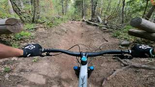
The bottom section has seen some work in recent years to add in some switch backs. Some beautiful sections through a meadow, but a lot of this trail is very steep and can be pretty washed out. Also as typical with this area of AF, dirtbikes can rut it out in the shady areas. Best down or bring a granny gear.

This trail is a blast downhill, one of my favorite downhill trails, really fast with several root drops that you can double up on and one wheel trap that is fun hit. Some of the washed out sections have big berms and you can flow down them.

Access Info

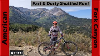
Access from the Tibble Fork Reservoir. Also common to shuttle to the summit parking lot and ride down from Ridge 157

Trail Supporters

  • USFS
    Land Manager
Traditionally Indigenous Territory

Recent Activity on Trail

Past Week
  • 2 rides
  • 19.7 km average
6 Months
  • 7 rides
  • 27.4 km avg distance
All
  • 179 rides
  • Last: Jun 28, 2026
c1c2c3c4
January
February
March
April
May
June
July
August
September
October
November
December
update trails status or condition

Tibble Fork, Upper Trail Reports

statusdatedescription
Jun 6, 2026 @ 12:26pm (America/Denver)
Jun 6, 2026
Open for Summer
Jun 6, 2026 @ 9:22am (America/Denver)
Jun 6, 2026
Trail is bike & moto open now
Apr 19, 2026 @ 9:33am (America/Denver)
Apr 19, 2026
This trail is now under the USFS springtime wet trails closure. Closed to everything except hiking.
Sep 27, 2025 @ 10:09am (America/Denver)
Sep 27, 2025
Aug 28, 2025 @ 10:00am
Aug 28, 2025
more »
Status:
on Jun 6, 2026
Very Dry
Avg: 4.5 (27 votes)
Your vote: 0

view (2,258)
close
3D
Trail Conditions
  • Unknown
  • Snow Groomed
  • Snow Packed
  • Snow Covered
  • Snow Cover Partial
  • Freeze/thaw Cycle
  • Icy
  • Prevalent Mud
  • Wet
  • Variable
  • Ideal
  • Dry
  • Very Dry
Trail Flow (Ridden Direction)
Trailforks scans users ridelogs to determine the most popular direction each trail is ridden. A good flowing trail network will have most trails flowing in a single direction according to their intension.
The colour categories are based on what percentage of riders are riding a trail in its intended direction.
  • > 96%
  • > 90%
  • > 80%
  • > 70%
  • > 50%
  • < 50%
  • bi-directional trail
  • no data
Trail Last Ridden
Trailforks scans ridelogs to determine the last time a trail was ridden.
  • < 2 days
  • < 1 week
  • < 2 weeks
  • < 1 month
  • < 6 months
  • > 6 months
Trail Ridden Direction
The intended direction a trail should be ridden.
  • Downhill Only
  • Downhill Primary
  • Both Directions
  • Uphill Primary
  • Uphill Only
  • One Direction
Contribute Details
Colors indicate trail is missing specified detail.
  • Description
  • Photos
  • Description & Photos
  • Videos
Trail Popularity ?
Trailforks scans ridelogs to determine which trails are ridden the most in the last 9 months. Trails are compared with nearby trails in the same city region with a possible 25 colour shades. Think of this as a heatmap, more rides = more kinetic energy = warmer colors.
  • most popular
  • popular
  • less popular
  • not popular
ATV/ORV/OHV Filter
Max Vehicle Width
inches
US Cell Coverage
Legend
cell carrier legend

Radar Time
Activity Recordings
Trailforks uses anonymized public activity data. ?
Activity Recordings
Trailforks uses anonymized public activity data. ?
Personal Heatmap
Activity Types
all / none
Options
2
Date range month
Winter Trails
Warning A routing network for winter maps does not exist. Selecting trails using the winter trails layer has been disabled.
Missing Trails
Most Popular
Least Popular
Trails are colored based on popularity. The more popular a trail is, the more red. Less popular trails trend towards green.
Jump Magnitude Heatmap
Heatmap of where riders jump on trails. Zoom in to see individual jumps, click circles to view jump details.
BC Backroad Status

Service Road Atlas is a free to use, community-driven service for viewing and creating reports on the numerous back-country service roads around B.C. and Alberta.

map legend
Slope Aspect
Direction the slope faces
Flat N NE E SE S SW W NW
Trails Deemphasized
Trails are shown in grey.
disable
Only show trails with no bike usage.
Enable
Suggested Layers
Based on selected activity type

    Save the current map location and zoom level as your default home location whenever this page is loaded.

    Save
        Directions to tibble-fork-upper trailhead (40.459050, -111.614500)

        Photos

        16 more »
        118 |
        Oct 21, 2022 @ 8:12pm
        Oct 21, 2022
        310 |
        Jan 27, 2020 @ 1:50pm
        Jan 27, 2020
        177 |
        Aug 14, 2019 @ 8:41pm
        Aug 14, 2019
        46 |
        Jul 2, 2024 @ 1:54pm
        Jul 2, 2024

        Videos

        7 more »
        youtuber Utah Mountain Biking Trails | Ridge Trail to...
        15:19 | 573 | Dec 8, 2018 , Cedar Hills
        youtuber Flying down American Fork Canyon in fall...
        20:55 | 62 | Oct 3, 2025 , Cedar Hills
        Tibble Fork
        12:22 | 480 | Jun 1, 2021 , Cedar Hills
        Tibble Fork Aug 2020
        11:06 | 171 | Sep 25, 2020 , Cedar Hills

        Routes with this trail

        4.0 8 miles 2,190 ft 3 Loop
        This is a fun loop starting at Reservoir. Cross American Fork River on the east end of the reservoir and...
        24 miles 4,911 ft 9 Loop
        All motorized trail loop that starts and ends at Bear Canyon. This loop pushes the limit of your battery a...
        4 miles 1,061 ft 5 Loop
        Great ride route in the spring/summer/fall OR Snowshoe/Fatbike in the winter. A couple short but very...

        8 Reviews & Comments


        We hope you've been enjoying Trailforks!

        Create a FREE account to view trail comments and much more.

        • By toddTF Pro Trailforks & contributors
        • #9383 - 8,639 views

        Frequently Asked Questions About Tibble Fork, Upper

        Where is Tibble Fork, Upper located?
        Tibble Fork, Upper is located in American Fork Canyon, Cedar Hills, Utah, United States. It is part of the American Fork Canyon trail network. The trailhead is located at coordinates 40.45905, -111.6145.
        How hard is Tibble Fork, Upper?
        Tibble Fork, Upper is rated as Black Diamond difficulty. The physical rating is Extreme. The average grade is 10.3%. The climb difficulty is rated Black Diamond.
        What is the elevation gain for Tibble Fork, Upper?
        Tibble Fork, Upper has 3 ft of elevation gain. The trail has 1,385 ft of elevation descent. The elevation ranges from 6,707 ft to 8,090 ft.
        Is Tibble Fork, Upper a point to point trail?
        Tibble Fork, Upper is not a point to point trail. The direction is Downhill Primary. The trail type is singletrack.

        Hit the Trail

        Open in App

        Get this trail on your phone instantly.
        open trail in app

        Download Trail

        Save to wishlist, Garmin & download.
        save the trail

        Find Related Routes

        Find routes and users activities that include this trail.
        find routes for this trail

        You must enter a description before submitting.