more stats
4,268 ft
Distance
16 ft
Climb
-294 ft
Descent
00:03:37
Avg time
-276 ft
Altitude change
359 ft
Altitude min
639 ft
Altitude max
639 ft
Altitude start
364 ft
Altitude end
-6.5%
Grade
-26.1%
Grade max
13.8%
Grade min
427 ft
Distance climb
3,419 ft
Distance down
423 ft
Distance flat
00:03:37
Avg time

Tip Run Details

  • Activities
    • Mountain Bike
    • E-Bike
    • Winter Fat Bike
  • Riding Area
    Mt Taylor MTB Park
    Mt Taylor
  • Difficulty Rating
  • Local Popularity
    100 in Mountain Biking [+]
    • 95 in E-Biking
  • Global Ranking
    #43632 in Mountain Biking [+]
    • #5688 in E-Biking
  • Trail Type
    Machine Groomed
  • Bike Type
    DH, AM, XC, DJ, Fat
  • Direction
    Downhill Only
    Popular Direction Shown
  • Physical Rating
    Easy
  • Trail Visibility
    Always easy to follow
  • eBike Allowed
    Yes up to Class 1
  • TTFs on Trail
    Berm, Jump, Roller Coaster
  • Year Opened
    2019
  • Land Owner
    DEECA

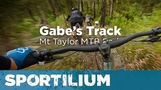
Fast and flowy machine-built trail, jam packed with features.

Can be accessed off the fire road (Milkys Run) either at the top or mid point, or link in from Loosen Up/Time to Drop for a fun final blast back to the trailhead.

Access Info

Ride up the fire road (Milkies Run) up to Ledoux's Track, or ride up The Big Emu and then onto Milky Way trail.

Local Trail Association
Traditionally Indigenous Territory

Recent Activity on Trail

Past Week
  • 0 rides
  •  
6 Months
  • 8 rides
  • 11 miles avg distance
All
  • 133 rides
  • Last: Jun 6, 2026
c1c2c3c4
January
February
March
April
May
June
July
August
September
October
November
December
update trails status or condition

Tip Run Trail Reports

statusdatedescription
Jun 1, 2025 @ 11:53pm
Jun 1, 2025
Bridge works complete.
Jun 1, 2025 @ 3:22pm
Jun 1, 2025
Closed for bridge replacement works.
Apr 5, 2025 @ 1:43pm
Apr 5, 2025
Feb 15, 2025 @ 2:39pm
Feb 15, 2025
bridge out at the bottom
Nov 19, 2024 @ 11:55pm
Nov 19, 2024
more »
Status:
on Jun 1, 2025
Ideal
Avg: 3.99 (4 votes)
Your vote: 0

view (1,321)
close
3D
Trail Conditions
  • Unknown
  • Snow Groomed
  • Snow Packed
  • Snow Covered
  • Snow Cover Partial
  • Freeze/thaw Cycle
  • Icy
  • Prevalent Mud
  • Wet
  • Variable
  • Ideal
  • Dry
  • Very Dry
Trail Flow (Ridden Direction)
Trailforks scans users ridelogs to determine the most popular direction each trail is ridden. A good flowing trail network will have most trails flowing in a single direction according to their intension.
The colour categories are based on what percentage of riders are riding a trail in its intended direction.
  • > 96%
  • > 90%
  • > 80%
  • > 70%
  • > 50%
  • < 50%
  • bi-directional trail
  • no data
Trail Last Ridden
Trailforks scans ridelogs to determine the last time a trail was ridden.
  • < 2 days
  • < 1 week
  • < 2 weeks
  • < 1 month
  • < 6 months
  • > 6 months
Trail Ridden Direction
The intended direction a trail should be ridden.
  • Downhill Only
  • Downhill Primary
  • Both Directions
  • Uphill Primary
  • Uphill Only
  • One Direction
Contribute Details
Colors indicate trail is missing specified detail.
  • Description
  • Photos
  • Description & Photos
  • Videos
Trail Popularity ?
Trailforks scans ridelogs to determine which trails are ridden the most in the last 9 months. Trails are compared with nearby trails in the same city region with a possible 25 colour shades. Think of this as a heatmap, more rides = more kinetic energy = warmer colors.
  • most popular
  • popular
  • less popular
  • not popular
ATV/ORV/OHV Filter
Max Vehicle Width
inches
US Cell Coverage
Legend
cell carrier legend

Radar Time
Activity Recordings
Trailforks uses anonymized public activity data. ?
Activity Recordings
Trailforks uses anonymized public activity data. ?
Personal Heatmap
Activity Types
all / none
Options
2
Date range month
Winter Trails
Warning A routing network for winter maps does not exist. Selecting trails using the winter trails layer has been disabled.
Missing Trails
Most Popular
Least Popular
Trails are colored based on popularity. The more popular a trail is, the more red. Less popular trails trend towards green.
Jump Magnitude Heatmap
Heatmap of where riders jump on trails. Zoom in to see individual jumps, click circles to view jump details.
BC Backroad Status

Service Road Atlas is a free to use, community-driven service for viewing and creating reports on the numerous back-country service roads around B.C. and Alberta.

map legend
Slope Aspect
Direction the slope faces
Flat N NE E SE S SW W NW
Trails Deemphasized
Trails are shown in grey.
disable
Only show trails with no bike usage.
Enable
Suggested Layers
Based on selected activity type

    Save the current map location and zoom level as your default home location whenever this page is loaded.

    Save
        Directions to tip-run trailhead (-37.698720, 147.571940)

        Photos

        7 more »
        94 |
        Sep 20, 2020 @ 4:01pm
        Sep 20, 2020
        62 |
        Sep 18, 2020 @ 5:04am
        Sep 18, 2020
        68 |
        Sep 18, 2020 @ 5:03am
        Sep 18, 2020
        60 |
        Sep 18, 2020 @ 5:02am
        Sep 18, 2020

        Videos

        3 more »
        youtuber My First Podium \\  Mt Taylor MTB Park
        31:11 | 140 | Jul 7, 2024 , Mt Taylor
        youtuber Mt Taylor Redemption Ride
        4:07 | 447 | Oct 8, 2020 , Mt Taylor
        youtuber Mount Taylor - Tip Run
        4:50 | 22 | Oct 13, 2023 , Mt Taylor
        youtuber Gabe's Track – Mt Taylor
        10:58 | 239 | Dec 22, 2022 , Mt Taylor

        1 Review & Comments


        We hope you've been enjoying Trailforks!

        Create a FREE account to view trail comments and much more.

        • By flyingbananaTF Pro MTBEG MTBEG & contributors
        • #233201 - 1,627 views

        Frequently Asked Questions About Tip Run

        Where is Tip Run located?
        Tip Run is located in Mt Taylor MTB Park, Mt Taylor, Australia. It is part of the Mt Taylor MTB Park trail network. The trailhead is located at coordinates -37.69872, 147.57194.
        How hard is Tip Run?
        Tip Run is rated as Blue difficulty. The physical rating is Easy. The average grade is 6.5%.
        What is the elevation gain for Tip Run?
        Tip Run has 16 ft of elevation gain. The trail has 294 ft of elevation descent. The elevation ranges from 359 ft to 639 ft.
        Is Tip Run a point to point trail?
        Yes, Tip Run is a point to point trail. The direction is Downhill Only. The trail type is machine groomed.

        Hit the Trail

        Open in App

        Get this trail on your phone instantly.
        open trail in app

        Download Trail

        Save to wishlist, Garmin & download.
        save the trail

        Find Related Routes

        Find routes and users activities that include this trail.
        find routes for this trail

        You must enter a description before submitting.