more stats
1,778 ft
Distance
2 ft
Climb
-151 ft
Descent
00:02:05
Avg time
-149 ft
Altitude change
220 ft
Altitude min
368 ft
Altitude max
368 ft
Altitude start
220 ft
Altitude end
-8.4%
Grade
-31.5%
Grade max
2.8%
Grade min
98 ft
Distance climb
1,677 ft
Distance down
00:02:05
Avg time

Tomac Details

  • Activities
    • Mountain Bike
    • E-Bike
  • Riding Area
  • Difficulty Rating
  • Voted Difficulty
    Red (1 vote)
  • Local Popularity
    60 in Mountain Biking [+]
    • 65 in E-Biking
  • Global Ranking
    #12252 in Mountain Biking [+]
    • #55511 in E-Biking
  • Trail Type
    Singletrack
  • Bike Type
    AM
  • Direction
    Downhill Only
    Popular Direction Shown
  • Physical Rating
    Moderate
  • Trail Visibility
    Sometimes hard to follow
  • eBike Allowed

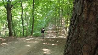
Ten zjazd jest to tzw "bula" skoczni narciarskiej powstałej w 1930r w Dolinie Henrietty ( nazwa Doliny Samborowo z czasów Wolnego Miasta Gdańska ) Skocznia była aktywnym narciarsko obiektem w latach 1930 do1970. Skoczkowie osiągali tu loty rzędu 35m.
Rowerowo została odkryta przez kolarzy MTB XC w okolicach 1993r. Ostatnie kilka lat była nieużywana ze względu na wiatrołom na przeciwstoku gdzie wytraca się prędkość.
21.06.2021 wiatrołom jest usunięty, przejazd oczyszczony i teren lekko wyrównany.
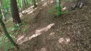
Ze względu nierówności i nieużytkowanie trasy ciężko jest rozpędzić tu rower do dawnych prędkości, gdy kiedyś po puszczeniu hamulców bez jednego nawet ruchu korbą rower osiągał ponad 75km/h. Ludzie pedałujący na dojeździe zbliżali się do 100km/h. W latach 90 była tu idealna twarda wyjeżdżona gładź niczym beton na lotnisku. Mimo wszystko jest to niebezpieczny zjazd, po minięciu progu buli raczej niebezpiecznie jest hamować, prędkość wytraca się podjeżdżając przeciwstok gdzie trzeba odbić w lewo na trawers. Nie jest to zjazd dla początkujących kolarzy i bez sprawdzenia przy pomocy wizyty od dołu spodu trasy może być śmiertelnie niebezpieczny. Warto udać się najpierw tam "Powrotem z miejsca zbrodni", obejrzeć czy wiatr nie zwalił nowych przeszkód i najlepiej pozostawić kumpla na dole by zabezpieczał trasę przed przypadkowym osobami lub okazjonalnym dzikiem / łosiem Wink

This trail is unsanctioned.

Recent Activity on Trail

Past Week
  • 0 rides
  •  
6 Months
  • 5 rides
  • 13 miles avg distance
All
  • 107 rides
  • Last: Jun 6, 2026
c1c2c3c4
January
February
March
April
May
June
July
August
September
October
November
December
update trails status or condition

Tomac Trail Reports

statusdatedescription
Jun 6, 2026 @ 12:39pm (Europe/Warsaw)
Jun 6, 2026
Czysto, bez gałęzi. Zjazd robi wrażenie, jest moc, dojeżdża się aż na samą górę gdzie zakręca ścieżka.
May 27, 2026 @ 5:16pm (Europe/Warsaw)
May 27, 2026
May 7, 2026 @ 6:32pm (Europe/Warsaw)
May 7, 2026
Jul 13, 2025 @ 7:25am
Jul 13, 2025
Jun 2, 2025 @ 3:12pm
Jun 2, 2025
more »
Status:
on Jun 6, 2026
Ideal
Avg: 4.32 (3 votes)
Your vote: 0

view (523)
close
3D
Trail Conditions
  • Unknown
  • Snow Groomed
  • Snow Packed
  • Snow Covered
  • Snow Cover Partial
  • Freeze/thaw Cycle
  • Icy
  • Prevalent Mud
  • Wet
  • Variable
  • Ideal
  • Dry
  • Very Dry
Trail Flow (Ridden Direction)
Trailforks scans users ridelogs to determine the most popular direction each trail is ridden. A good flowing trail network will have most trails flowing in a single direction according to their intension.
The colour categories are based on what percentage of riders are riding a trail in its intended direction.
  • > 96%
  • > 90%
  • > 80%
  • > 70%
  • > 50%
  • < 50%
  • bi-directional trail
  • no data
Trail Last Ridden
Trailforks scans ridelogs to determine the last time a trail was ridden.
  • < 2 days
  • < 1 week
  • < 2 weeks
  • < 1 month
  • < 6 months
  • > 6 months
Trail Ridden Direction
The intended direction a trail should be ridden.
  • Downhill Only
  • Downhill Primary
  • Both Directions
  • Uphill Primary
  • Uphill Only
  • One Direction
Contribute Details
Colors indicate trail is missing specified detail.
  • Description
  • Photos
  • Description & Photos
  • Videos
Trail Popularity ?
Trailforks scans ridelogs to determine which trails are ridden the most in the last 9 months. Trails are compared with nearby trails in the same city region with a possible 25 colour shades. Think of this as a heatmap, more rides = more kinetic energy = warmer colors.
  • most popular
  • popular
  • less popular
  • not popular
ATV/ORV/OHV Filter
Max Vehicle Width
inches
US Cell Coverage
Legend
cell carrier legend

Radar Time
Activity Recordings
Trailforks uses anonymized public activity data. ?
Activity Recordings
Trailforks uses anonymized public activity data. ?
Personal Heatmap
Activity Types
all / none
Options
2
Date range month
Winter Trails
Warning A routing network for winter maps does not exist. Selecting trails using the winter trails layer has been disabled.
Missing Trails
Most Popular
Least Popular
Trails are colored based on popularity. The more popular a trail is, the more red. Less popular trails trend towards green.
Jump Magnitude Heatmap
Heatmap of where riders jump on trails. Zoom in to see individual jumps, click circles to view jump details.
BC Backroad Status

Service Road Atlas is a free to use, community-driven service for viewing and creating reports on the numerous back-country service roads around B.C. and Alberta.

map legend
Slope Aspect
Direction the slope faces
Flat N NE E SE S SW W NW
Trails Deemphasized
Trails are shown in grey.
disable
Only show trails with no bike usage.
Enable
Suggested Layers
Based on selected activity type

    Save the current map location and zoom level as your default home location whenever this page is loaded.

    Save
        Directions to tomac trailhead (54.383560, 18.559410)

        Photos

        3 more »
        236 |
        Aug 14, 2021 @ 9:37am
        Aug 14, 2021

        Videos

        3 more »
        Zawody Pomerania 2022 - zjazd 'Tomac'
        19:11 | 310 | Sep 4, 2022 , Gdańsk
        Skocznia narciarska 'Tomac' w Dolinie...
        0:29 | 299 | Aug 30, 2022 , Gdańsk
        zjazd Tomac 2007 rok
        0:18 | 533 | Jun 29, 2021 , Gdańsk

        Trail Lists

        Routes with this trail

        5.0 21 miles 2,784 ft 29 Loop
        Jest to trasa pod rowery do cross country z droperem. Nie ma tu hopek, pionowych dropów czy gapów, ale...

        2 Reviews & Comments


        We hope you've been enjoying Trailforks!

        Create a FREE account to view trail comments and much more.

        • #445328 - 1,499 views

        Frequently Asked Questions About Tomac

        Where is Tomac located?
        Tomac is located in Dolina Samborowo, Gdańsk, Poland. It is part of the Dolina Samborowo trail network. The trailhead is located at coordinates 54.38356, 18.55941.
        How hard is Tomac?
        Tomac is rated as Red difficulty. The physical rating is Moderate. The average grade is 8.4%.
        What is the elevation gain for Tomac?
        Tomac has 2 ft of elevation gain. The trail has 151 ft of elevation descent. The elevation ranges from 220 ft to 368 ft.
        Is Tomac a point to point trail?
        Yes, Tomac is a point to point trail. The direction is Downhill Only. The trail type is singletrack.

        Hit the Trail

        Open in App

        Get this trail on your phone instantly.
        open trail in app

        Download Trail

        Save to wishlist, Garmin & download.
        save the trail

        Find Related Routes

        Find routes and users activities that include this trail.
        find routes for this trail

        You must enter a description before submitting.