more stats
2,198 ft
Distance
4 ft
Climb
-238 ft
Descent
00:02:29
Avg time
-235 ft
Altitude change
127 ft
Altitude min
361 ft
Altitude max
361 ft
Altitude start
128 ft
Altitude end
-10.7%
Grade
-40.5%
Grade max
8.7%
Grade min
43 ft
Distance climb
1,808 ft
Distance down
348 ft
Distance flat
00:02:29
Avg time

Tomahawk Details

  • Activities
    • Mountain Bike
  • Riding Area
  • Difficulty Rating
  • Voted Difficulty
    Blue (1 vote)
  • Local Popularity
    95 in Mountain Biking
  • Global Ranking
    #2015 in Mountain Biking
  • Trail Type
    Singletrack
  • Bike Type
    DH, AM, XC
  • Direction
    Downhill Only
    Popular Direction Shown
  • Dogs Allowed
    Yes
  • TTFs on Trail
    Berm, Drop, Jump
  • Land Owner
    L\'Abbaye d\'Oka

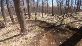
Fast, very fast but oh soooo smooth.
There's an optional Jump on the right side before reaching l'Abbé Canne but it also has a wide pass to its left, the new lower section has some pretty steep sections.

Local Trail Association

Recent Activity on Trail

Past Week
  • 13 rides
  • 8 miles average
6 Months
  • 64 rides
  • 8 miles avg distance
All
  • 1,719 rides
  • Last: Jun 3, 2026
c1c2c3c4
January
February
March
April
May
June
July
August
September
October
November
December
update trails status or condition

Tomahawk Trail Reports

Status:
on Apr 25, 2026
Dry
Avg: 4.27 (42 votes)
Your vote: 0

view (10,305)
close
3D
Trail Conditions
  • Unknown
  • Snow Groomed
  • Snow Packed
  • Snow Covered
  • Snow Cover Partial
  • Freeze/thaw Cycle
  • Icy
  • Prevalent Mud
  • Wet
  • Variable
  • Ideal
  • Dry
  • Very Dry
Trail Flow (Ridden Direction)
Trailforks scans users ridelogs to determine the most popular direction each trail is ridden. A good flowing trail network will have most trails flowing in a single direction according to their intension.
The colour categories are based on what percentage of riders are riding a trail in its intended direction.
  • > 96%
  • > 90%
  • > 80%
  • > 70%
  • > 50%
  • < 50%
  • bi-directional trail
  • no data
Trail Last Ridden
Trailforks scans ridelogs to determine the last time a trail was ridden.
  • < 2 days
  • < 1 week
  • < 2 weeks
  • < 1 month
  • < 6 months
  • > 6 months
Trail Ridden Direction
The intended direction a trail should be ridden.
  • Downhill Only
  • Downhill Primary
  • Both Directions
  • Uphill Primary
  • Uphill Only
  • One Direction
Contribute Details
Colors indicate trail is missing specified detail.
  • Description
  • Photos
  • Description & Photos
  • Videos
Trail Popularity ?
Trailforks scans ridelogs to determine which trails are ridden the most in the last 9 months. Trails are compared with nearby trails in the same city region with a possible 25 colour shades. Think of this as a heatmap, more rides = more kinetic energy = warmer colors.
  • most popular
  • popular
  • less popular
  • not popular
ATV/ORV/OHV Filter
Max Vehicle Width
inches
US Cell Coverage
Legend
cell carrier legend

Radar Time
Activity Recordings
Trailforks uses anonymized public activity data. ?
Activity Recordings
Trailforks uses anonymized public activity data. ?
Personal Heatmap
Activity Types
all / none
Options
2
Date range month
Winter Trails
Warning A routing network for winter maps does not exist. Selecting trails using the winter trails layer has been disabled.
Missing Trails
Most Popular
Least Popular
Trails are colored based on popularity. The more popular a trail is, the more red. Less popular trails trend towards green.
Jump Magnitude Heatmap
Heatmap of where riders jump on trails. Zoom in to see individual jumps, click circles to view jump details.
BC Backroad Status

Service Road Atlas is a free to use, community-driven service for viewing and creating reports on the numerous back-country service roads around B.C. and Alberta.

map legend
Slope Aspect
Direction the slope faces
Flat N NE E SE S SW W NW
Trails Deemphasized
Trails are shown in grey.
disable
Only show trails with no bike usage.
Enable
Suggested Layers
Based on selected activity type

    Save the current map location and zoom level as your default home location whenever this page is loaded.

    Save
        Directions to tomahawk trailhead (45.488970, -74.030040)

        Photos

        3 more »
        61 |
        Sep 29, 2023 @ 1:42pm
        Sep 29, 2023
        115 |
        Sep 29, 2023 @ 1:42pm
        Sep 29, 2023
        438 |
        Sep 18, 2017 @ 12:34pm
        Sep 18, 2017

        Videos

        13 more »
        Tomahawk//OKA QC//2022//First run down Tomahawk!
        2:22 | 343 | May 28, 2022 , Oka
        OKA SOUTH//OKA QC//2022//Exploring all the...
        44:00 | 131 | May 18, 2022 , Oka
        Piste Tomahawk
        0:56 | 151 | May 3, 2022 , Oka
        Tomahawk
        2:02 | 265 | May 2, 2022 , Oka

        9 Reviews & Comments


        We hope you've been enjoying Trailforks!

        Create a FREE account to view trail comments and much more.

        • By StephaneMarceauTF Pro TRAILFORKS & contributors
        • #31817 - 8,321 views

        Frequently Asked Questions About Tomahawk

        Where is Tomahawk located?
        Tomahawk is located in Sentiers de l'Abbaye d’Oka, Oka, Quebec, Canada. It is part of the Sentiers de l'Abbaye d’Oka trail network. The trailhead is located at coordinates 45.48897, -74.03004.
        How hard is Tomahawk?
        Tomahawk is rated as Black Diamond difficulty. The average grade is 10.7%.
        What is the elevation gain for Tomahawk?
        Tomahawk has 1 m of elevation gain. The trail has 73 m of elevation descent. The elevation ranges from 39 m to 110 m.
        Is Tomahawk a point to point trail?
        Yes, Tomahawk is a point to point trail. The direction is Downhill Only. The trail type is singletrack.

        Hit the Trail

        Open in App

        Get this trail on your phone instantly.
        open trail in app

        Download Trail

        Save to wishlist, Garmin & download.
        save the trail

        Find Related Routes

        Find routes and users activities that include this trail.
        find routes for this trail

        You must enter a description before submitting.