more stats
3,799 ft
Distance
18 ft
Climb
-637 ft
Descent
00:06:04
Avg time
-619 ft
Altitude change
105 ft
Altitude min
724 ft
Altitude max
724 ft
Altitude start
105 ft
Altitude end
-16.3%
Grade
-56.5%
Grade max
16.3%
Grade min
341 ft
Distance climb
3,383 ft
Distance down
79 ft
Distance flat
00:06:04
Avg time

Tornante second part Details

  • Activities
    • Mountain Bike
    • E-Bike
    • Winter Fat Bike
    • Hike
    • Trail Running
  • Riding Area
    SanFé Micro Park
    San Fedele
  • Difficulty Rating
  • Local Popularity
    85 in Mountain Biking [+]
    • 80 in E-Biking
    • 70 in Trail Running
    • 5 in Hiking
    • 5 in Winter Fat Biking
  • Global Ranking
    #50503 in Mountain Biking [+]
    • #842 in E-Biking
    • #145158 in Trail Running
    • #341523 in Hiking
    • #5399 in Winter Fat Biking
  • National Ranking
    #4,573 in Mountain Biking · Italy [+]
    • #197 in E-Biking
    • #4,640 in Trail Running
    • #13,155 in Hiking
    • #241 in Winter Fat Biking
  • Trail Type
    Singletrack
  • Bike Type
    AM, XC, Fat
  • Direction
    Downhill Primary
    Popular Direction Shown
  • Physical Rating
    Hard
  • Season
    All year
  • Dogs Allowed
    Yes
  • eBike Allowed
    Yes up to Class 1

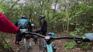
IT : Sentiero completamente restaurato. La prima parte è flow con sponde e qualche salto., La parte centrale é un tipico sentiero ligure composto da roccia e radici, parte finale caratterizzata da tornanti lavorati e spondati, molto veloce.

ENG :Path completely restored. The first part is flow with banks and some jumps., The central part is a typical Ligurian path composed of rock and roots, the final part is characterized by worked and banked hairpin bends, very fast.

Access Info

IT : L' imbocco del sentiero si trova seguendo la salita che porta al monte Bignone. Vari Cartelli posizionati all' inizio del sentiero.
ENG : The entrance to the path is found following the slope that leads to Mount Bignone. Various signs positioned at the beginning of the path.

Tags
Jumps

Trail Supporters

Local Trail Association

Recent Activity on Trail

Past Week
  • 2 rides
  • 52.9 km average
6 Months
  • 22 rides
  • 38.5 km avg distance
All
  • 82 rides
  • Last: Oct 22, 2026
c1c2c3c4
January
February
March
April
May
June
July
August
September
October
November
December
update trails status or condition

Tornante second part Trail Reports

statusdatedescription
Sep 22, 2026 @ 4:38pm (Europe/Rome)
Sep 22, 2026
Abbastanza scavato, tutto fattibile ma abbastanza impegnativo
Sep 19, 2026 @ 1:44pm (Europe/Rome)
Sep 19, 2026
secco ma bello...impegnativo,forse un rosso
May 21, 2026 @ 10:34pm (Europe/Rome)
May 21, 2026
May 19, 2026 @ 4:20pm (Europe/Rome)
May 19, 2026
this trail is really flowy, nice turns, almost like in a Bike Park
Mar 8, 2026 @ 9:39am (Europe/Monaco)
Mar 8, 2026
more »
Status:
on Sep 22, 2026
Very Dry
Avg: 4.2 (10 votes)
Your vote: 0

view (778)
close
      Directions to tornante-second-part trailhead (44.041080, 8.197150)

      Photos

      16 more »
      mtb
      101 |
      Nov 25, 2021 @ 12:36am
      Nov 25, 2021
      mtb
      105 |
      Nov 25, 2021 @ 12:36am
      Nov 25, 2021
      mtb
      138 |
      Nov 26, 2020 @ 4:15am
      Nov 26, 2020
      mtb
      120 |
      Nov 26, 2020 @ 4:14am
      Nov 26, 2020

      Videos

      3 more »
      Alassio Trails - Fonte Carbonara  & Tornante
      mtb
      211 | Apr 29, 2026 , San Fedele
      Tornante First + Second - Alassio, Italy -...
      mtb
      95 | Feb 23, 2025 , San Fedele
      youtuber Finale Ligure   Backcountry Tour Alassio -...
      ebike
      18:43 | 234 | Feb 16, 2026 , San Fedele

      Routes with this trail

      17 miles • 3,857 ft • 9 • Loop •
      GALLINARA FREERIDE BLACK LINE ROUTE. START POINT IN ALBENGA, FOLLOW THE JULIA AUGUSTA, NICE AND EASY WARM...
      13 miles • 2,681 ft • 7 • Loop •
      GALLINARA FREERIDE BLACK LINE ROUTE. START POINT IN ALBENGA, FOLLOW THE JULIA AUGUSTA, NICE AND EASY WARM...
      4.3 ★★★★★
      10 Ratings
      5 ★ 50%
      4 ★ 40%
      3 ★
      2 ★ 10%
      1 ★

      Reviews / Comments

      No reviews yet, be the first to write a review or ask a question.
      Use trail reports to comment on trail conditions.


      We hope you've been enjoying Trailforks!

      Create a FREE account to view all trail reviews and much more.

      Frequently Asked Questions

      ▼ Where is Tornante second part located?
      Tornante second part is located in SanFé Micro Park, San Fedele, Italy. It is part of the SanFé Micro Park trail network. The trailhead is located at coordinates 44.04108, 8.19715.
      ▼ How hard is Tornante second part?
      Tornante second part is rated as Blue difficulty. The physical rating is Hard. The average grade is 16.3%.
      ▼ What is the elevation gain for Tornante second part?
      Tornante second part has 18 ft of elevation gain. The trail has 637 ft of elevation descent. The elevation ranges from 105 ft to 724 ft.
      ▼ Is Tornante second part a point to point trail?
      Tornante second part is not a point to point trail. The direction is Downhill Primary. The trail type is singletrack.
      ▼ How long is Tornante second part?
      Tornante second part is 3,799 ft long. The trail type is singletrack.
      ▼ Are dogs allowed on Tornante second part?
      Yes, dogs are allowed on Tornante second part. Please keep dogs on a leash where required and clean up after them.
      ▼ When is the best time of year to ride Tornante second part?
      Based on activity log data, the most popular months to ride Tornante second part are:
      • October (12 activities)
      • May (10 activities)
      • September (9 activities)
      Check the reports page for current trail conditions.
      ▼ How do I access Tornante second part? Where is the closest parking trailhead?
      The closest parking and trailhead locations to Tornante second part are: View all parking locations in the area.
      ▼ How long does it take to ride Tornante second part?
      Based on recorded activities, it takes an average of 6 minutes to ride Tornante second part. The trail is 3,799 ft long. Actual times will vary based on fitness level, conditions, and pace. View recent activity logs for more details.
      ▼ How busy is Tornante second part?
      Tornante second part is a very popular trail. There have been 748 recorded activities on this trail. The trail has received 778 check-ins. View recent activity on this trail.

      Hit the Trail

      Open in App

      Get this trail on your phone instantly.

      open trail in app

      Download Trail

      Save to wishlist, Garmin & download.
      save the trail

      Find Related Routes

      Find routes and users activities that include this trail.
      find routes for this trail

      You must enter a description before submitting.