more stats
2.0 miles
Distance
53 ft
Climb
-57 ft
Descent
00:09:08
Avg time
-3 ft
Altitude change
46 ft
Altitude min
65 ft
Altitude max
65 ft
Altitude start
62 ft
Altitude end
-7.5%
Grade max
15.7%
Grade min
1,588 ft
Distance climb
1,565 ft
Distance down
1 mile
Distance flat
00:09:08
Avg time

Tower Loop Details

  • Activities
    • Mountain Bike
    • Winter Fat Bike
    • Hike
    • Trail Running
  • Riding Area
    Brazos River Trails
    Sugar Land, Texas
  • Difficulty Rating
  • Voted Difficulty
    Green (3 votes)
  • Local Popularity
    100 in Mountain Biking [+]
    • 90 in Trail Running
    • 100 in Hiking
  • Global Ranking
    #3006 in Mountain Biking [+]
    • #20831 in Trail Running
    • #49145 in Hiking
  • Trail Type
    Singletrack
  • Bike Type
    AM, XC, Fat
  • Direction
    One Direction
  • Climb Difficulty
    Green
  • Physical Rating
    Moderate
  • Trail Visibility
    Always easy to follow
  • Dogs Allowed
    Yes
  • TTFs on Trail
    Berm, Jump

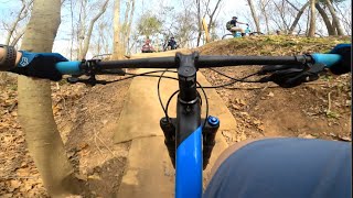
It's a one way fast, flowy, smooth trail. It's also beginner friendly. In November 2020 it was expanded to be a 2+ mile loop. This trail has some steep drops to look out for at beginning of trail, and a couple big dips. Otherwise, it is small rollers, little climbs, a few berms and jumps, but mainly fast flow.

Access Info

Ride sidewalk into south most paved loop. Trailhead is directly off the sidewalk

Trail Supporters
Local Trail Association
Traditionally Indigenous Territory

Recent Activity on Trail

Past Week
  • 0 rides
  •  
6 Months
  • 203 rides
  • 13 miles avg distance
All
  • 2,076 rides
  • Last: Jun 13, 2026
c1c2c3c4
January
February
March
April
May
June
July
August
September
October
November
December
update trails status or condition

Tower Loop Trail Reports

statusdatedescription
Jun 13, 2026 @ 12:49pm (America/Matamoros)
Jun 13, 2026
Jun 12, 2026 @ 11:08am (America/Chicago)
Jun 12, 2026
Mostly dry About a doz mud puddles 2 puddles on approach to Bridge ar 1.95 mile point Don’t stop. Crazy Skeeters
Jun 2, 2026 @ 10:21am (America/Chicago)
Jun 2, 2026
Sum mud puddles Otherwise just damp However, rain this afternoon may close it again
May 5, 2026 @ 5:57pm (America/Matamoros)
May 5, 2026
Some soft pots but rideable.
Apr 27, 2026 @ 6:13pm (America/Matamoros)
Apr 27, 2026
Some mud pockets, easy to avoid
more »
Status:
on Jun 13, 2026
Variable
Avg: 4.55 (14 votes)
Your vote: 0

view (15,495)
close
3D
Trail Conditions
  • Unknown
  • Snow Groomed
  • Snow Packed
  • Snow Covered
  • Snow Cover Partial
  • Freeze/thaw Cycle
  • Icy
  • Prevalent Mud
  • Wet
  • Variable
  • Ideal
  • Dry
  • Very Dry
Trail Flow (Ridden Direction)
Trailforks scans users ridelogs to determine the most popular direction each trail is ridden. A good flowing trail network will have most trails flowing in a single direction according to their intension.
The colour categories are based on what percentage of riders are riding a trail in its intended direction.
  • > 96%
  • > 90%
  • > 80%
  • > 70%
  • > 50%
  • < 50%
  • bi-directional trail
  • no data
Trail Last Ridden
Trailforks scans ridelogs to determine the last time a trail was ridden.
  • < 2 days
  • < 1 week
  • < 2 weeks
  • < 1 month
  • < 6 months
  • > 6 months
Trail Ridden Direction
The intended direction a trail should be ridden.
  • Downhill Only
  • Downhill Primary
  • Both Directions
  • Uphill Primary
  • Uphill Only
  • One Direction
Contribute Details
Colors indicate trail is missing specified detail.
  • Description
  • Photos
  • Description & Photos
  • Videos
Trail Popularity ?
Trailforks scans ridelogs to determine which trails are ridden the most in the last 9 months. Trails are compared with nearby trails in the same city region with a possible 25 colour shades. Think of this as a heatmap, more rides = more kinetic energy = warmer colors.
  • most popular
  • popular
  • less popular
  • not popular
ATV/ORV/OHV Filter
Max Vehicle Width
inches
US Cell Coverage
Legend
cell carrier legend

Radar Time
Activity Recordings
Trailforks uses anonymized public activity data. ?
Activity Recordings
Trailforks uses anonymized public activity data. ?
Personal Heatmap
Activity Types
all / none
Options
2
Date range month
Winter Trails
Warning A routing network for winter maps does not exist. Selecting trails using the winter trails layer has been disabled.
Missing Trails
Most Popular
Least Popular
Trails are colored based on popularity. The more popular a trail is, the more red. Less popular trails trend towards green.
Jump Magnitude Heatmap
Heatmap of where riders jump on trails. Zoom in to see individual jumps, click circles to view jump details.
BC Backroad Status

Service Road Atlas is a free to use, community-driven service for viewing and creating reports on the numerous back-country service roads around B.C. and Alberta.

map legend
Slope Aspect
Direction the slope faces
Flat N NE E SE S SW W NW
Trails Deemphasized
Trails are shown in grey.
disable
Only show trails with no bike usage.
Enable
Suggested Layers
Based on selected activity type

    Save the current map location and zoom level as your default home location whenever this page is loaded.

    Save
        Directions to tower-loop-85115 trailhead (29.565020, -95.657470)

        Photos

        36 more »
        44 |
        Nov 22, 2025 @ 11:41am
        Nov 22, 2025
        94 |
        Jun 28, 2025 @ 11:02am
        Jun 28, 2025
        130 |
        Nov 30, 2024 @ 5:47am
        Nov 30, 2024
        72 |
        Feb 22, 2024 @ 3:34am
        Feb 22, 2024

        Videos

        2 more »
        Sugar Land Classic 2025 | Sugar Land, TX |...
        24:46 | 135 | May 16, 2025 , Sugar Land
        Flat terrain can be Fun! Mountain Biking...
        17:03 | 510 | Jan 23, 2022 , Sugar Land

        Trail Lists

        Routes with this trail

        11 miles 282 ft 11
        A nice beginner trail map for those venturing out to Sugar Land for the first time. You can also add in...
        4 miles 100 ft 3 Race
        https://fbmba.org/pages/feel-the-love-relay
        6 miles 143 ft 6 Loop Race
        The Candy Rush NICA MTB race is a comprised of a mix of green trails spanning 6 miles. As a participant in...

        6 Reviews & Comments


        We hope you've been enjoying Trailforks!

        Create a FREE account to view trail comments and much more.

        • By toddTF Pro Trailforks & contributors
        • #85115 - 10,562 views

        Frequently Asked Questions About Tower Loop

        Where is Tower Loop located?
        Tower Loop is located in Brazos River Trails, Sugar Land, Texas, United States. It is part of the Brazos River Trails trail network. The trailhead is located at coordinates 29.56502, -95.65747.
        How hard is Tower Loop?
        Tower Loop is rated as Green difficulty. The physical rating is Moderate. The climb difficulty is rated Green.
        What is the elevation gain for Tower Loop?
        Tower Loop has 53 ft of elevation gain. The trail has 57 ft of elevation descent. The elevation ranges from 46 ft to 65 ft.
        Is Tower Loop a point to point trail?
        Yes, Tower Loop is a point to point trail. The direction is One Direction. The trail type is singletrack.

        Hit the Trail

        Open in App

        Get this trail on your phone instantly.
        open trail in app

        Download Trail

        Save to wishlist, Garmin & download.
        save the trail

        Find Related Routes

        Find routes and users activities that include this trail.
        find routes for this trail

        You must enter a description before submitting.