more stats
1.5 miles
Distance
186 ft
Climb
-506 ft
Descent
00:13:57
Avg time
-320 ft
Altitude change
104 ft
Altitude min
529 ft
Altitude max
425 ft
Altitude start
105 ft
Altitude end
-19.557%
Grade max
21.135%
Grade min
2,402 ft
Distance climb
5,272 ft
Distance down
316 ft
Distance flat
00:13:57
Avg time

Trail 41 (Lower) Details

  • Activities
    • Mountain Bike
    • E-Bike
    • Horse
    • Hike
    • Trail Running
  • Riding Area
    Fort Ord National Monument
    Monterey, California
  • AKA
    Lower Goat
  • Difficulty Rating
  • Voted Difficulty
    Blue (2 votes)
  • Local Popularity
    75 in Mountain Biking heatmap [+]
    • 85 in E-Biking
    • 80 in Trail Running
    • 55 in Hiking
    • 5 in Horseback
  • Global Ranking
    #71296 in Mountain Biking [+]
    • #89581 in E-Biking
    • #109104 in Trail Running
    • #142401 in Hiking
    • #3394 in Horseback
  • State Ranking
    #2,238 in Mountain Biking · California [+]
    • #1,818 in E-Biking
    • #5,325 in Trail Running
    • #8,193 in Hiking
    • #282 in Horseback
  • Trail Type
    Singletrack
  • Bike Type
    XC
  • Direction
    Both Directions
    Popular Direction Shown
  • Climb Difficulty
    Blue
  • Physical Rating
    Moderate
  • Season
    All Year
  • Dogs Allowed
    Yes
  • eBike Allowed
    Yes up to Class 1
  • Land Owner

CYCLIST NOTES:
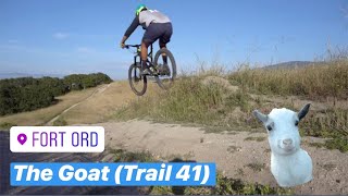
The lower section is a fun and flowing ride down the ridge through oaks with a couple of steep sections that can get a bit rutted. The best on the mountain Super fun zipping in and out of treed sections. The top of the lower section has a bench and a great view.

NATIONAL MONUMENT NOTES:
This BLM managed trail is open from dawn to dusk to cyclists, hikers/joggers, and equestrians. The trail is two-way directional, and cyclists must yield to all other users; hikers/joggers must yield to equestrians. Maximum passing speed limit is less than 5 mph for cyclists for oncoming trail users and when passing those that have slowed/stopped and moved to edge of trail. Please leash your pet.

Access Info

Access via Jacks Rd heading South OR Oil Well Rd heading West.

Tags
Picnic spotViews

Trail Supporters

  • BLM
    BLM
    Land Manager

Local Trail Association

Traditionally Indigenous Territory

Recent Activity on Trail

Past Week
  • 3 rides
  • 19 miles average
6 Months
  • 72 rides
  • 16 miles avg distance
All
  • 1,178 rides
  • Last: Nov 15, 2026
c1c2c3c4
January
February
March
April
May
June
July
August
September
October
November
December
Status:
on Jul 21, 2026
Ideal
Avg: 4.31 (17 votes)
Your vote: 0

view (6,330)
close
      Directions to trail-41-lower trailhead (36.610700, -121.711020)

      Photos

      14 more »
      mtb
      98 |
      Oct 10, 2023 @ 3:45pm
      Oct 10, 2023
      mtb
      246 |
      Jan 8, 2022 @ 4:01pm
      Jan 8, 2022
      mtb
      245 |
      Apr 17, 2019 @ 11:22pm
      Apr 17, 2019
      mtb
      251 |
      Apr 17, 2019 @ 11:22pm
      Apr 17, 2019

      Videos

      2 more »
      Fort Ord Mountain Biking: Trail 41 (The Goat...
      mtb
      3:36 | 1999 | Jun 5, 2019 , Monterey
      youtuber Fort Ord CA: Trail 41 Lower
      ebike
      17:34 | 336 | Feb 21, 2025 , Monterey

      Routes with this trail

      more »
      15 miles • 2,074 ft • 531 • Loop •
      This is a fun tour of the various trails connected to the Creekside parking lot, and a great introduction...
      ★ 4.0 • 10 miles • 1,168 ft • 10 • Loop •
      Loop route that showcases much of the terrain at Fort Ord.
      ★ 4.0 • 15 miles • 2,289 ft • 263 • Loop •
      1.5-2 hour loop highlighting some of the best single track and descents in Fort Ord. A local favorite!
      4.3 ★★★★★
      17 Ratings
      5 ★ 59%
      4 ★ 18%
      3 ★ 18%
      2 ★ 6%
      1 ★

      4 Reviews & Comments

      BrendanOUwJSn
      Some okay sections but almost all of the decent berms are rutted out. Poorly maintained and seemingly a shadow of what this trail used to be. Needs a ton of work to get back to potential, disappointing.
      logan24
      Had high hopes based on the other comments, but unfortunately didn't love this trail or most of the northeast side of the park tbh (I did a 24 mile route entering from the northwest). As mentioned, thistrail widens out into a steep fire road at times with crazy ruts. It's rideable but never felt flowy, on those parts or the singletrack. Lower part was better, but thought Trail 50 was a much more fun descent overall. Scenery was good at least! Give it a shot, I'm probably just weird.
      windsurfsf windsurfsf
      Longest and fastest downhill singletrack in Ord, and thus the most fun too. Probably the signature trail for the area, great trail to finish on (almost).

      We hope you've been enjoying Trailforks!

      Create a FREE account to view all trail reviews and much more.

      • By jboom & contributors
      • #27041 - 4,526 views

      Frequently Asked Questions

      ▼ Where is Trail 41 (Lower) located?
      Trail 41 (Lower) is located in Fort Ord National Monument, Monterey, California, United States. It is part of the Fort Ord National Monument trail network. The trailhead is located at coordinates 36.6107, -121.71102.
      ▼ How hard is Trail 41 (Lower)?
      Trail 41 (Lower) is rated as Blue difficulty. The physical rating is Moderate. The climb difficulty is rated Blue.
      ▼ What is the elevation gain for Trail 41 (Lower)?
      Trail 41 (Lower) has 186 ft of elevation gain. The trail has 506 ft of elevation descent. The elevation ranges from 104 ft to 529 ft.
      ▼ Is Trail 41 (Lower) a point to point trail?
      Trail 41 (Lower) is not a point to point trail. The direction is Both Directions. The trail type is singletrack.
      ▼ How long is Trail 41 (Lower)?
      Trail 41 (Lower) is 1.5 miles long. The trail type is singletrack.
      ▼ Are dogs allowed on Trail 41 (Lower)?
      Yes, dogs are allowed on Trail 41 (Lower). Please keep dogs on a leash where required and clean up after them.
      ▼ When is the best time of year to ride Trail 41 (Lower)?
      Based on activity log data, the most popular months to ride Trail 41 (Lower) are:
      • January (59 activities)
      • November (51 activities)
      • February (48 activities)
      Check the reports page for current trail conditions.
      ▼ How do I access Trail 41 (Lower)? Where is the closest parking trailhead?
      The closest parking and trailhead locations to Trail 41 (Lower) are: View all parking locations in the area.
      ▼ How long does it take to ride Trail 41 (Lower)?
      Based on recorded activities, it takes an average of 14 minutes to ride Trail 41 (Lower). The trail is 1.5 miles long. Actual times will vary based on fitness level, conditions, and pace. View recent activity logs for more details.
      ▼ How busy is Trail 41 (Lower)?
      Trail 41 (Lower) is a very popular trail. There have been 6,404 recorded activities on this trail. The trail has received 6,330 check-ins. View recent activity on this trail.

      Hit the Trail

      Open in App

      Get this trail on your phone instantly.

      open trail in app

      Download Trail

      Save to wishlist, Garmin & download.
      save the trail

      Find Related Routes

      Find routes and users activities that include this trail.
      find routes for this trail

      You must enter a description before submitting.