more stats
3.2 miles
Distance
393 ft
Climb
-400 ft
Descent
00:33:34
Avg time
-4 ft
Altitude change
8,290 ft
Altitude min
8,638 ft
Altitude max
8,638 ft
Altitude start
8,635 ft
Altitude end
-26.3%
Grade max
18.3%
Grade min
1 mile
Distance climb
1 mile
Distance down
2,526 ft
Distance flat
00:33:34
Avg time

Trail Yeah! Details

  • Activities
    • Mountain Bike
    • Hike
    • Trail Running
  • Riding Area
  • Difficulty Rating
  • Voted Difficulty
    Blue (2 votes)
  • Local Popularity
    5 in Mountain Biking [+]
    • 5 in Trail Running
    • 5 in Hiking
  • Global Ranking
    #144338 in Mountain Biking [+]
    • #129642 in Trail Running
    • #122612 in Hiking
  • Hiking SAC Scale
    T2 Mountain Hiking
  • Trail Type
    Singletrack
  • Direction
    Both Directions
  • Climb Difficulty
    Blue
  • Physical Rating
    Moderate
  • Dogs Allowed
    Yes

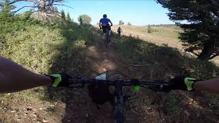
Yeah!! is a beauty with flowing turns in either direction. The trail is masterfully planned through the aspen, furs, and meadows. This trail will take you into the areas of Powder Mountain that are truly delightful.

When you are on your ride take some time to enjoy the views and realize that you are biking on a section of the mountain that is normally accessed by a snow cat or ski skins.

This is an area on the mountain that makes you want to say "natures neat"!

Traditionally Indigenous Territory

Recent Activity on Trail

Past Week
  • 0 rides
  •  
6 Months
  • 0 rides
  •  
All
  • 241 rides
  • Last: Sep 2, 2019
c1c2c3c4
January
February
March
April
May
June
July
August
September
October
November
December
update trails status or condition

Trail Yeah! Trail Reports

statusdatedescription
May 24, 2024 @ 6:47am
May 24, 2024
Bike Park trails will be closed for the season
May 15, 2024 @ 5:37am
May 15, 2024
Bike Park remains closed until further notice.
Oct 22, 2023 @ 8:24am
Oct 22, 2023
Some spots were wet mainly on northern faces but the mud wasn’t deep, and the trail is rideable.
Aug 27, 2023 @ 8:18am
Aug 27, 2023
Rained last night. Trail had a few puddles in all the usual places, would have better to wait 1 more day.
Aug 23, 2023 @ 2:44pm
Aug 23, 2023
more »
Status:
on May 24, 2024
Avg: 3.59 (9 votes)
Your vote: 0

view (1,764)
close
3D
Trail Conditions
  • Unknown
  • Snow Groomed
  • Snow Packed
  • Snow Covered
  • Snow Cover Partial
  • Freeze/thaw Cycle
  • Icy
  • Prevalent Mud
  • Wet
  • Variable
  • Ideal
  • Dry
  • Very Dry
Trail Flow (Ridden Direction)
Trailforks scans users ridelogs to determine the most popular direction each trail is ridden. A good flowing trail network will have most trails flowing in a single direction according to their intension.
The colour categories are based on what percentage of riders are riding a trail in its intended direction.
  • > 96%
  • > 90%
  • > 80%
  • > 70%
  • > 50%
  • < 50%
  • bi-directional trail
  • no data
Trail Last Ridden
Trailforks scans ridelogs to determine the last time a trail was ridden.
  • < 2 days
  • < 1 week
  • < 2 weeks
  • < 1 month
  • < 6 months
  • > 6 months
Trail Ridden Direction
The intended direction a trail should be ridden.
  • Downhill Only
  • Downhill Primary
  • Both Directions
  • Uphill Primary
  • Uphill Only
  • One Direction
Contribute Details
Colors indicate trail is missing specified detail.
  • Description
  • Photos
  • Description & Photos
  • Videos
Trail Popularity ?
Trailforks scans ridelogs to determine which trails are ridden the most in the last 9 months. Trails are compared with nearby trails in the same city region with a possible 25 colour shades. Think of this as a heatmap, more rides = more kinetic energy = warmer colors.
  • most popular
  • popular
  • less popular
  • not popular
ATV/ORV/OHV Filter
Max Vehicle Width
inches
US Cell Coverage
Legend
cell carrier legend

Radar Time
Activity Recordings
Trailforks uses anonymized public activity data. ?
Activity Recordings
Trailforks uses anonymized public activity data. ?
Personal Heatmap
Activity Types
all / none
Options
2
Date range month
Winter Trails
Warning A routing network for winter maps does not exist. Selecting trails using the winter trails layer has been disabled.
Missing Trails
Most Popular
Least Popular
Trails are colored based on popularity. The more popular a trail is, the more red. Less popular trails trend towards green.
Jump Magnitude Heatmap
Heatmap of where riders jump on trails. Zoom in to see individual jumps, click circles to view jump details.
BC Backroad Status

Service Road Atlas is a free to use, community-driven service for viewing and creating reports on the numerous back-country service roads around B.C. and Alberta.

map legend
Slope Aspect
Direction the slope faces
Flat N NE E SE S SW W NW
Trails Deemphasized
Trails are shown in grey.
disable
Only show trails with no bike usage.
Enable
Suggested Layers
Based on selected activity type

    Save the current map location and zoom level as your default home location whenever this page is loaded.

    Save
        Directions to trail-yeah trailhead (41.376110, -111.734880)

        Photos

        11 more »
        80 |
        Oct 16, 2022 @ 9:38pm
        Oct 16, 2022
        67 |
        Jul 4, 2022 @ 3:31pm
        Jul 4, 2022
        81 |
        Jul 4, 2022 @ 3:31pm
        Jul 4, 2022
        72 |
        Jul 4, 2022 @ 3:31pm
        Jul 4, 2022

        Videos

        2 more »
        Mountain Bike: Trail Yeah! at Powder Mountain
        10:43 | 291 | Sep 7, 2021 , Eden
        Powder Mountain: How to find the Magic Bus on...
        9:17 | 2816 | Aug 19, 2021 , Eden

        Routes with this trail

        16 miles 1,494 ft 12 Loop
        Powder Mountain loop including Brim, , and .
        21 miles 2,210 ft 8 Loop
        Bonneville MTB Team route plan for 09.17.22

        6 Reviews & Comments


        We hope you've been enjoying Trailforks!

        Create a FREE account to view trail comments and much more.

        • By wisemtnbkrTF Pro & contributors
        • #149503 - 3,816 views

        Frequently Asked Questions About Trail Yeah!

        Where is Trail Yeah! located?
        Trail Yeah! is located in Powder Mountain Resort, Eden, Utah, United States. It is part of the Powder Mountain Resort trail network. The trailhead is located at coordinates 41.37611, -111.73488.
        How hard is Trail Yeah!?
        Trail Yeah! is rated as Blue difficulty. The physical rating is Moderate. The climb difficulty is rated Blue.
        What is the elevation gain for Trail Yeah!?
        Trail Yeah! has 393 ft of elevation gain. The trail has 400 ft of elevation descent. The elevation ranges from 8,290 ft to 8,638 ft.
        Is Trail Yeah! a point to point trail?
        Trail Yeah! is not a point to point trail. The direction is Both Directions. The trail type is singletrack.

        Hit the Trail

        Open in App

        Get this trail on your phone instantly.
        open trail in app

        Download Trail

        Save to wishlist, Garmin & download.
        save the trail

        Find Related Routes

        Find routes and users activities that include this trail.
        find routes for this trail

        You must enter a description before submitting.