more stats
3,304 ft
Distance
8 ft
Climb
-454 ft
Descent
00:08:39
Avg time
-446 ft
Altitude change
2,433 ft
Altitude min
2,879 ft
Altitude max
2,879 ft
Altitude start
2,434 ft
Altitude end
-13.5%
Grade
-50.8%
Grade max
8.2%
Grade min
148 ft
Distance climb
2,717 ft
Distance down
328 ft
Distance flat
00:08:39
Avg time

Tricky Bits Details

  • Activities
    • Mountain Bike
  • Riding Area
    Kruger Mountain/Blue Lake/Kilpoola
    Osoyoos, British Columbia
  • Difficulty Rating
  • Local Popularity
    95 in Mountain Biking
  • Global Ranking
    #49674 in Mountain Biking
  • Trail Type
    Singletrack
  • Bike Type
    DH, AM, XC
  • Direction
    Downhill Only
    Popular Direction Shown
  • Physical Rating
    Moderate
  • Dogs Allowed
    Yes
  • TTFs on Trail
    Berm, Drop, Jump, Rock Face

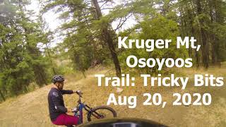
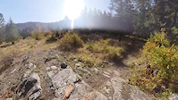
Tricky Bits is fast singletrack with a double drop, natural rock-launch over a 12 foot table with wide wooden transition, steep rock face, a small rock drop, a 100 ft long berm and a wooden drop named "Big Boy Pants". Ya so basically jammed full of TTFs. The rock face is approximately 30 feet in height with an average overall grade of 48%. There is now also a chicken line around the rock face for those not ready for it.

Access Info

Roll off of Cowbell into a tight left turn.

This trail is unsanctioned.

Disclaimer

Unsanctioned, ride at your own risk

Trail Supporters

Recent Activity on Trail

Past Week
  • 0 rides
  •  
6 Months
  • 17 rides
  • 9 miles avg distance
All
  • 147 rides
  • Last: Jun 21, 2026
c1c2c3c4
January
February
March
April
May
June
July
August
September
October
November
December
update trails status or condition

Tricky Bits Trail Reports

statusdatedescription
Apr 3, 2026 @ 3:43pm (America/Vancouver)
Apr 3, 2026
running smooth
Mar 20, 2026 @ 8:51pm (America/Vancouver)
Mar 20, 2026
in great shape. Well cared for
Aug 11, 2025 @ 8:33am
Aug 11, 2025
In great shape!!
Jun 17, 2025 @ 9:16pm
Jun 17, 2025
reporter
Trail now trimmed and mostly raked. F'ing awesome right now!
Apr 14, 2025 @ 1:04pm
Apr 14, 2025
reporter Trees cleared from trail and important sections have been raked. Some water flowing on trail in 2 sections otherwise trail is ideal!
more »
Status:
on Apr 3, 2026
Ideal
Avg: 4.31 (10 votes)
Your vote: 0

view (390)
close
3D
Trail Conditions
  • Unknown
  • Snow Groomed
  • Snow Packed
  • Snow Covered
  • Snow Cover Partial
  • Freeze/thaw Cycle
  • Icy
  • Prevalent Mud
  • Wet
  • Variable
  • Ideal
  • Dry
  • Very Dry
Trail Flow (Ridden Direction)
Trailforks scans users ridelogs to determine the most popular direction each trail is ridden. A good flowing trail network will have most trails flowing in a single direction according to their intension.
The colour categories are based on what percentage of riders are riding a trail in its intended direction.
  • > 96%
  • > 90%
  • > 80%
  • > 70%
  • > 50%
  • < 50%
  • bi-directional trail
  • no data
Trail Last Ridden
Trailforks scans ridelogs to determine the last time a trail was ridden.
  • < 2 days
  • < 1 week
  • < 2 weeks
  • < 1 month
  • < 6 months
  • > 6 months
Trail Ridden Direction
The intended direction a trail should be ridden.
  • Downhill Only
  • Downhill Primary
  • Both Directions
  • Uphill Primary
  • Uphill Only
  • One Direction
Contribute Details
Colors indicate trail is missing specified detail.
  • Description
  • Photos
  • Description & Photos
  • Videos
Trail Popularity ?
Trailforks scans ridelogs to determine which trails are ridden the most in the last 9 months. Trails are compared with nearby trails in the same city region with a possible 25 colour shades. Think of this as a heatmap, more rides = more kinetic energy = warmer colors.
  • most popular
  • popular
  • less popular
  • not popular
ATV/ORV/OHV Filter
Max Vehicle Width
inches
US Cell Coverage
Legend
cell carrier legend

Radar Time
Activity Recordings
Trailforks uses anonymized public activity data. ?
Activity Recordings
Trailforks uses anonymized public activity data. ?
Personal Heatmap
Activity Types
all / none
Options
2
Date range month
Winter Trails
Warning A routing network for winter maps does not exist. Selecting trails using the winter trails layer has been disabled.
Missing Trails
Most Popular
Least Popular
Trails are colored based on popularity. The more popular a trail is, the more red. Less popular trails trend towards green.
Jump Magnitude Heatmap
Heatmap of where riders jump on trails. Zoom in to see individual jumps, click circles to view jump details.
BC Backroad Status

Service Road Atlas is a free to use, community-driven service for viewing and creating reports on the numerous back-country service roads around B.C. and Alberta.

map legend
Slope Aspect
Direction the slope faces
Flat N NE E SE S SW W NW
Trails Deemphasized
Trails are shown in grey.
disable
Only show trails with no bike usage.
Enable
Suggested Layers
Based on selected activity type

    Save the current map location and zoom level as your default home location whenever this page is loaded.

    Save
        Directions to tricky-bits trailhead (49.044250, -119.544890)

        Photos

        21 more »
        142 |
        Dec 2, 2020 @ 9:17pm
        Dec 2, 2020
        152 |
        Dec 2, 2020 @ 9:17pm
        Dec 2, 2020
        175 |
        Nov 18, 2018 @ 10:02pm
        Nov 18, 2018
        158 |
        Nov 18, 2018 @ 10:02pm
        Nov 18, 2018

        Videos

        7 more »
        youtuber Can't wait to come back here! Mountain biking...
        11:51 | 676 | Mar 24, 2021 , Osoyoos
        youtuber Osoyoos...who knew?!?
        6:22 | 336 | Jul 6, 2023 , Osoyoos
        Tricky Bits
        2:48 | 426 | Sep 1, 2020 , Osoyoos
        Rock Launch on Tricky bits
        0:08 | 569 | Mar 23, 2019 , Osoyoos

        Routes with this trail

        8 miles 1,876 ft 6 Loop
        The hardest loop on the mountain, Parking by the Gun Range, on , this route is for those that like to...
        4 miles 235 ft 4 Point to Point
        Strawberry Creeks Iconic, was the first black trail available on the mountain. With steep rock chutes,...
        4 miles 226 ft 4 Out & Back
        Strawberry Creeks Iconic, "Tricky bits" trail, was the first black trail available on the mountain. With...

        4 Reviews & Comments


        We hope you've been enjoying Trailforks!

        Create a FREE account to view trail comments and much more.

        • #146193 - 2,985 views

        Frequently Asked Questions About Tricky Bits

        Where is Tricky Bits located?
        Tricky Bits is located in Kruger Mountain/Blue Lake/Kilpoola, Osoyoos, British Columbia, Canada. It is part of the Kruger Mountain/Blue Lake/Kilpoola trail network. The trailhead is located at coordinates 49.04425, -119.54489.
        How hard is Tricky Bits?
        Tricky Bits is rated as Black Diamond difficulty. The physical rating is Moderate. The average grade is 13.5%.
        What is the elevation gain for Tricky Bits?
        Tricky Bits has 8 ft of elevation gain. The trail has 454 ft of elevation descent. The elevation ranges from 2,433 ft to 2,879 ft.
        Is Tricky Bits a point to point trail?
        Yes, Tricky Bits is a point to point trail. The direction is Downhill Only. The trail type is singletrack.

        Hit the Trail

        Open in App

        Get this trail on your phone instantly.
        open trail in app

        Download Trail

        Save to wishlist, Garmin & download.
        save the trail

        Find Related Routes

        Find routes and users activities that include this trail.
        find routes for this trail

        You must enter a description before submitting.