2,903 ft
Distance
48 ft
Climb
-103 ft
Descent
00:12:19
Avg time
Truite Details
-
Riding areaMont-Tremblant
Ville de Mont-Tremblant, Quebec -
AKALa Truite
-
Difficulty rating
-
Trail typeSingletrack
-
Bike typeAM, XC, Fat
-
Trail UsageBiking Primary
-
DirectionBoth Directions
-
Climb DifficultyBlue
-
Physical ratingEasy
-
eBike AllowedYes
-
TTFs on trailBridge, Jump
-
Ride in rainYes
-
Global Ranking
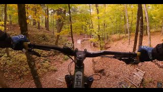
A bit rocky at the start but the rest is a beautiful trail through open woods. Your main access to the trail network from the Old Village (Lac Mercier).
Point de départ pour le secteur du Village, cette piste vous donnera accès à un magnifique terrain de jeux.
Local Trail Association
-
Vélo Mont-Tremblant
(www.velomonttremblant.com) Please consider joining or donating to the local riding association to support trail development & maintenance.donate to earn trail karma!
More Stats for Truite mountain bike trail
-
Altitude change-55 ft
-
Altitude min738 ft
-
Altitude max812 ft
-
Altitude start793 ft
-
Altitude end738 ft
-
Grade-1.879%
-
Grade max-33.011%
-
Grade min15.907%
-
Distance climb1,236 ft
-
Distance down1,503 ft
-
Distance flat164 ft
-
Avg time00:12:19
-
Avg reverse time00:11:06
- view trail stats
close
Trail Conditions
- Unknown
- Snow Packed
- Snow Covered
- Freeze/thaw Cycle
- Icy
- Prevalent Mud
- Wet
- Variable
- Dry
- Very Dry
Directions to truite trailhead
(46.194550, -74.611760)
update trails status or condition
Truite Trail Reports
view all reports »
Photos
more »
Reviews / Comments
No reviews yet, be the first to write a review or ask a question.
Use trail reports to comment on trail conditions.
Videos
no videos have been added for Truite yet, add a video.
Nearby Trails
- jim minty 3 miles
- embed Truite trail on your website
- By Mavrey & contributors
- #7275 - 801 views
- subscribe
- login to download gpx or kml files.
Open trail in mobile app