




more stats
778 ft
Distance
-153 ft
Descent
00:01:26
Avg time
-153 ft
Altitude change
732 ft
Altitude min
886 ft
Altitude max
885 ft
Altitude start
732 ft
Altitude end
-19.7%
Grade
-39.7%
Grade max
1.5%
Grade min
62 ft
Distance climb
620 ft
Distance down
66 ft
Distance flat
00:01:26
Avg time

Tuliki Details

  • Activities
    • Mountain Bike
    • E-Bike
    • Hike
    • Trail Running
  • Riding Area
    Almendrales
    Málaga
  • Difficulty Rating
  • Local Popularity
    95 in Mountain Biking [+]
    • 95 in E-Biking
    • 5 in Trail Running
    • 5 in Hiking
  • Global Ranking
    #65439 in Mountain Biking [+]
    • #56653 in E-Biking
    • #380169 in Trail Running
    • #374366 in Hiking
  • National Ranking
    #4,417 in Mountain Biking · Spain [+]
    • #5,052 in E-Biking
    • #42,446 in Trail Running
    • #40,401 in Hiking
  • Hiking SAC Scale
    T1 Hiking
  • Trail Exposure
    Normal
  • Trail Type
    Singletrack
  • Bike Type
    DH, AM
  • Climb Difficulty
    Blue
  • Physical Rating
    Moderate
  • Trail Visibility
    Always easy to follow
  • Dogs Allowed
    Yes
  • eBike Allowed
  • TTFs on Trail
    Drop
  • Ride in Rain
    Yes

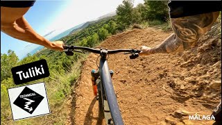
Primer tramo hasta la pista mas vertical, con curvas y con algunos escalones pronunciados, pero con apoyos y peraltes bien construidos. Atención con el cortado con el que termina en la pista.

Access Info

Acceso por carril desde casi la parte mas alta de la zona.

Tags
Drops

Recent Activity on Trail

Past Week
  • 0 rides
  •  
6 Months
  • 2 rides
  • 15 miles avg distance
All
  • 19 rides
  • Last: Oct 5, 2026
update trails status or condition

Tuliki Trail Reports

statusdatedescription
Oct 4, 2026 @ 6:29pm (Europe/Madrid)
Oct 4, 2026
May 11, 2026 @ 8:43pm (Europe/Madrid)
May 11, 2026
Muy muy guapa y bien cuidada, ojo al acantilado al final! jeje
Aug 28, 2025 @ 10:40am
Aug 28, 2025
Super bonita con deop final
Apr 20, 2025 @ 9:47am
Apr 20, 2025
Muy limpita en perfecto estado de uso!
Mar 27, 2025 @ 3:36pm
Mar 27, 2025
more »
Status:
on Oct 4, 2026
Dry
Avg: 4.13 (3 votes)
Your vote: 0

view (201)
close
      Directions to tuliki trailhead (36.752090, -4.398010)

      Photos

      1 more »
      mtb
      61 |
      Mar 12, 2026 @ 9:33pm
      Mar 12, 2026

      Videos

      4 more »
      youtuber Tuliki | Single Black trail | Málaga mountain...
      mtb
      2:48 | 74 | Mar 14, 2026 , Málaga
      youtuber ‍♀️⛰ Homie| Los Almendrales | Málaga...
      ebike
      4:58 | 88 | May 13, 2025 , Málaga
      Trailforks #102 - La Homie (Almendrales - Málaga)
      ebike
      0:56 | 41 | Apr 18, 2025 , Málaga
      ️LOS ALMENDRALES: La Homie + La Homie Blue...
      ebike
      6:08 | 53 | Mar 24, 2025 , Málaga

      Routes with this trail

      19 miles • 4,650 ft • 27 • Loop •
      Enduro por Almendrales.
      4.7 ★★★★★
      3 Ratings
      5 ★ 67%
      4 ★ 33%
      3 ★
      2 ★
      1 ★

      1 Review & Comments

      allmountrailmtb allmountrailmtb
      Me dicen en un comentario de YouTube que el nombre que los constructores le han puesto a esta bajada es”La Tuli”. No tengo forma de contrastarlo más allá del comentario, pero aquí queda dicho.

      We hope you've been enjoying Trailforks!

      Create a FREE account to view all trail reviews and much more.

      • By MalagaRider & contributors
      • #834024 - 403 views

      Frequently Asked Questions

      ▼ Where is Tuliki located?
      Tuliki is located in Almendrales, Málaga, Spain. It is part of the Almendrales trail network. The trailhead is located at coordinates 36.75209, -4.39801.
      ▼ How hard is Tuliki?
      Tuliki is rated as Red difficulty. The physical rating is Moderate. The average grade is 19.7%. The climb difficulty is rated Blue.
      ▼ What is the elevation gain for Tuliki?
      The trail has 153 ft of elevation descent. The elevation ranges from 732 ft to 886 ft.
      ▼ How long is Tuliki?
      Tuliki is 778 ft long. The trail type is singletrack.
      ▼ Are dogs allowed on Tuliki?
      Yes, dogs are allowed on Tuliki. Please keep dogs on a leash where required and clean up after them.
      ▼ How do I access Tuliki? Where is the closest parking trailhead?
      The closest parking and trailhead locations to Tuliki are: View all parking locations in the area.
      ▼ How long does it take to ride Tuliki?
      Based on recorded activities, it takes an average of 1 minute to ride Tuliki. The trail is 778 ft long. Actual times will vary based on fitness level, conditions, and pace. View recent activity logs for more details.
      ▼ How busy is Tuliki?
      Tuliki is a very popular trail. There have been 149 recorded activities on this trail. The trail has received 201 check-ins. View recent activity on this trail.

      Hit the Trail

      Open in App

      Get this trail on your phone instantly.

      open trail in app

      Download Trail

      Save to wishlist, Garmin & download.
      save the trail

      Find Related Routes

      Find routes and users activities that include this trail.
      find routes for this trail

      You must enter a description before submitting.

