more stats
2.3 miles
Distance
195 ft
Climb
-1,331 ft
Descent
00:30:45
Avg time
-1,137 ft
Altitude change
3,655 ft
Altitude min
4,823 ft
Altitude max
4,792 ft
Altitude start
3,655 ft
Altitude end
-9.2%
Grade
-82.5%
Grade max
22.1%
Grade min
3,468 ft
Distance climb
2 miles
Distance down
381 ft
Distance flat
00:30:45
Avg time

Turbians Details

  • Activities
    • Mountain Bike
    • E-Bike
    • Hike
    • Trail Running
  • Riding Area
    El Berguedà
    Berga
  • Difficulty Rating
  • Voted Difficulty
    Red (1 vote)
  • Local Popularity
    90 in Mountain Biking [+]
    • 85 in E-Biking
    • 100 in Trail Running
    • 5 in Hiking
  • Global Ranking
    #120315 in Mountain Biking [+]
    • #80661 in E-Biking
    • #50161 in Trail Running
    • #207493 in Hiking
  • National Ranking
    #9,880 in Mountain Biking · Spain [+]
    • #15,158 in E-Biking
    • #2,995 in Trail Running
    • #12,148 in Hiking
  • Trail Type
    Singletrack
  • Bike Type
    AM
  • Direction
    Downhill Only
    Popular Direction Shown
  • Dogs Allowed
    Yes
  • eBike Allowed
    Yes up to Class 1

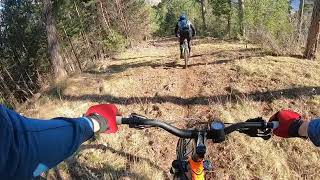
Cross country style start with a few small climbs over brings you to a fast fest downhill all the way down towards the village of Guardiola de Berguedà. Here you can choose between three different endings to your ride: Siti, Cucut or Les Arrels.

Tags

Recent Activity on Trail

Past Week
  • 0 rides
  •  
6 Months
  • 4 rides
  • 25 miles avg distance
All
  • 25 rides
  • Last: Sep 13, 2026
c1c2c3c4
January
February
March
April
May
June
July
August
September
October
November
December
update trails status or condition

Turbians Trail Reports

statusdatedescription
Aug 6, 2026 @ 9:46am (Europe/Andorra)
Aug 6, 2026
reporter Molt bon estat en general, només un arbre gran caigut just al final, es necessita motoserra
Jul 14, 2026 @ 7:50pm (Europe/Madrid)
Jul 14, 2026
Mar 18, 2026 @ 10:09am (Europe/Andorra)
Mar 18, 2026
Algun pino caído y sucio de ramas pero se puede hacer.
Apr 17, 2025 @ 10:23am
Apr 17, 2025
Mar 17, 2024 @ 1:24am
Mar 17, 2024
more »
Status:
on Aug 6, 2026
Ideal
Avg: 3.85 (8 votes)
Your vote: 0

view (225)
close
      Directions to turbians trailhead (42.246530, 1.825750)

      Photos

      4 more »
      mtb
      333 |
      Apr 29, 2019 @ 11:18pm
      Apr 29, 2019
      mtb
      118 |
      May 26, 2019 @ 8:20am
      May 26, 2019
      mtb
      122 |
      May 26, 2019 @ 8:20am
      May 26, 2019
      mtb
      134 |
      May 26, 2019 @ 8:19am
      May 26, 2019

      Videos

      4 more »
      Trialeras Turbians (por un mortal    ];-D}
      mtb
      5:38 | 303 | Jun 6, 2021 , Berga
      Turbians
      mtb
      3:49 | 416 | Feb 7, 2019 , Berga
      Turbians Turbo
      mtb
      0:43 | 84 | May 29, 2019 , Berga
      BAJADAS OCULTAS del Berguedá Norte | Enduro...
      ebike
      41:54 | 127 | Aug 23, 2026 , Berga
      3.8 ★★★★★
      8 Ratings
      5 ★ 38%
      4 ★ 25%
      3 ★ 13%
      2 ★ 25%
      1 ★

      6 Reviews & Comments

      Gelabert
      Penso el mateig fent una comparativa am altres rutes vermelles es una trialera vermella molt guapa pero vermella i combinada am altres sortin de inici desda el Collell es una corriolada brutal de vermello
      DavidwtPXye
      Pienso que debería ser de categoría roja por lo menos.
      MorettyBtt MorettyBtt
      Epic trail. És molt nivell. Blava d'alt calibre.

      We hope you've been enjoying Trailforks!

      Create a FREE account to view all trail reviews and much more.

      • By parlindholmTF Pro TFSPAIN & contributors
      • #166950 - 2,279 views

      Frequently Asked Questions

      ▼ Where is Turbians located?
      Turbians is located in El Berguedà, Berga, Spain. It is part of the El Berguedà trail network. The trailhead is located at coordinates 42.24653, 1.82575.
      ▼ How hard is Turbians?
      Turbians is rated as Blue difficulty. The average grade is 9.2%.
      ▼ What is the elevation gain for Turbians?
      Turbians has 195 ft of elevation gain. The trail has 1,331 ft of elevation descent. The elevation ranges from 3,655 ft to 4,823 ft.
      ▼ Is Turbians a point to point trail?
      Yes, Turbians is a point to point trail. The direction is Downhill Only. The trail type is singletrack.
      ▼ How long is Turbians?
      Turbians is 2.3 miles long. The trail type is singletrack.
      ▼ Are dogs allowed on Turbians?
      Yes, dogs are allowed on Turbians. Please keep dogs on a leash where required and clean up after them.
      ▼ When is the best time of year to ride Turbians?
      Based on activity log data, the most popular months to ride Turbians are:
      • August (3 activities)
      • October (3 activities)
      • November (3 activities)
      Check the reports page for current trail conditions.
      ▼ How do I access Turbians? Where is the closest parking trailhead?
      The closest parking and trailhead locations to Turbians are: View all parking locations in the area.
      ▼ How long does it take to ride Turbians?
      Based on recorded activities, it takes an average of 31 minutes to ride Turbians. The trail is 2.3 miles long. Actual times will vary based on fitness level, conditions, and pace. View recent activity logs for more details.
      ▼ How busy is Turbians?
      Turbians is a very popular trail. There have been 234 recorded activities on this trail. The trail has received 225 check-ins. View recent activity on this trail.

      Hit the Trail

      Open in App

      Get this trail on your phone instantly.

      open trail in app

      Download Trail

      Save to wishlist, Garmin & download.
      save the trail

      Find Related Routes

      Find routes and users activities that include this trail.
      find routes for this trail

      You must enter a description before submitting.