7.1 miles
Distance
813 ft
Climb
-837 ft
Descent
00:47:36
Avg time

Under The Radar Details

  • Activities
    • Mountain Bike
    • E-Bike
    • Hike
    • Trail Running
  • Riding Area
    Cape Pallarenda
    Townsville
  • AKA
    UTR
  • Difficulty Rating
  • Trail Type
    Singletrack
  • Bike Type
    XC
  • Direction
    Both Directions
    Popular direction shown
  • Climb Difficulty
    Blue
  • Physical Rating
    Moderate
  • Season
    Apr-Dec
  • eBike Allowed
    Yes up to Class 1
  • Global Ranking
    #5825 in Mountain Biking [+]
    • #2006 in E-Biking
    • #43095 in Trail Running
    • #81269 in Hiking
  • Local Popularity
    90 in Mountain Biking [+]
    • 90 in E-Biking
    • 95 in Trail Running
    • 80 in Hiking
  • Year Opened
    2012
  • Land Owner

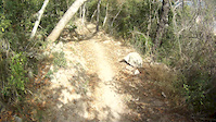
This narrow, two-way trail is designed for cross country mountain biking. Walkers must be alert and considerate for mountain bike riders approaching from either direction.

At its eastern end, UTR begins 700 m along the Shelly Cove trail and crosses the northern and western slopes of Many Peak Range. It provides excellent views of the islands to the north and the Coral Sea beyond. There is a link 6.6 km along UTR that leads to Smedley's trail. At its western end, UTR begins 500 m along the Shelly Beach trail in Townsville Town Common Regional Park. UTR has rough surfaces and some steep sections. Trail users can return the way they came or may use the other trails and internal park roads to return to their starting point.

Access Info

Head to Cape Pallarenda. Ride up the Shelley Cove trail, past the World War II forts. Single track starts on opposite side to the water.

Local Trail Association
Traditionally Indigenous Territory
More Stats for Under The Radar mountain bike trail trail
  • Altitude change
    -23 ft
  • Altitude min
    21 ft
  • Altitude max
    204 ft
  • Altitude start
    58 ft
  • Altitude end
    36 ft
  • Grade
    -0.1%
  • Grade max
    -25.3%
  • Grade min
    23%
  • Distance climb
    3 miles
  • Distance down
    3 miles
  • Distance flat
    1 mile
  • Avg time
    00:47:36
  • Avg reverse time
    00:58:33
  • view trail stats
Status:
on Mar 23, 2024
Dry
Avg: 4.5 (10 votes)
Your vote: 0

view (7,360)
close
3D
Trail Conditions
  • Unknown
  • Snow Groomed
  • Snow Packed
  • Snow Covered
  • Snow Cover Partial
  • Freeze/thaw Cycle
  • Icy
  • Prevalent Mud
  • Wet
  • Variable
  • Ideal
  • Dry
  • Very Dry
Trail Flow (Ridden Direction)
Trailforks scans users ridelogs to determine the most popular direction each trail is ridden. A good flowing trail network will have most trails flowing in a single direction according to their intension.
The colour categories are based on what percentage of riders are riding a trail in its intended direction.
  • > 96%
  • > 90%
  • > 80%
  • > 70%
  • > 50%
  • < 50%
  • bi-directional trail
  • no data
Trail Last Ridden
Trailforks scans ridelogs to determine the last time a trail was ridden.
  • < 2 days
  • < 1 week
  • < 2 weeks
  • < 1 month
  • < 6 months
  • > 6 months
Trail Ridden Direction
The intended direction a trail should be ridden.
  • Downhill Only
  • Downhill Primary
  • Both Directions
  • Uphill Primary
  • Uphill Only
  • One Direction
Contribute Details
Colors indicate trail is missing specified detail.
  • Description
  • Photos
  • Description & Photos
  • Videos
Trail Popularity ?
Trailforks scans ridelogs to determine which trails are ridden the most in the last 9 months. Trails are compared with nearby trails in the same city region with a possible 25 colour shades. Think of this as a heatmap, more rides = more kinetic energy = warmer colors.
  • most popular
  • popular
  • less popular
  • not popular
ATV/ORV/OHV Filter
Max Vehicle Width
inches
US Cell Coverage
Legend
cell carrier legend

Radar Time
x Activity Recordings
Trailforks users anonymized public ridelogs from the past 6 months.
  • mountain biking recent
  • mountain biking (>6 month)
  • hiking (1 year)
  • moto (1 year)
Activity Recordings
Trailforks users anonymized public skilogs from the past 12 months.
  • Downhill Ski
  • Backcountry Ski
  • Nordic Ski
  • Snowmobile
Winter Trails
Warning A routing network for winter maps does not exist. Selecting trails using the winter trails layer has been disabled.
x Missing Trails
Most Popular
Least Popular
Trails are colored based on popularity. The more popular a trail is, the more red. Less popular trails trend towards green.
Jump Magnitude Heatmap
Heatmap of where riders jump on trails. Zoom in to see individual jumps, click circles to view jump details.
Trails Deemphasized
Trails are shown in grey.
disable
Only show trails with NO bikes.
enable

Save the current map location and zoom level as your default home location whenever this page is loaded.

Save
      Directions to under-the-radar trailhead (-19.187720, 146.770700)
      update trails status or condition

      Under The Radar Trail Reports

      statusdatedescription
      Mar 23, 2024 @ 11:09pm
      Mar 23, 2024
      Extremely overgrown, grass is 8ft high and blocking the trail. Areas where prickle bushes also cover the trail. More like surfing your bike...
      Feb 12, 2024 @ 3:10am
      Feb 12, 2024
      05/02/24 - Extremely overgrown majority of the track. Grass at stages over head high. A few areas have thick roots and bushes over track and a...
      Jan 5, 2024 @ 10:48pm
      Jan 5, 2024
      Getting grassy now but still totally rideable. Could use a cut near the 4wd clearing, before the lookout climb and then right at the end just...
      Dec 13, 2023 @ 8:43am
      Dec 13, 2023
      small trees and branches on the trail from recent storms can walk around them. Track is wet and tall grasses are starting to grow taller
      Dec 10, 2023 @ 6:57am
      Dec 10, 2023
      There is a tree down at the start of the trail. You can get past it, but risk riding into the branches! I could not remove it
      view all reports »

      Recent Ridelog Activity on Trail

      Past Week
      • 24 rides
      • 16 miles avg distance
      6 Months
      • 175 rides
      • 14 miles avg distance
      All
      • 6,145 rides
      • Last: May 17, 2024

      Photos

      more »
      11 |
      Mar 23, 2024 @ 11:10pm
      Mar 23, 2024
      107 |
      Jun 30, 2021 @ 12:40am
      Jun 30, 2021
      171 |
      Mar 27, 2020 @ 11:02pm
      Mar 27, 2020
      188 |
      Mar 27, 2020 @ 1:39pm
      Mar 27, 2020

      Routes with this trail

      titledistance
      2015 Targa Townsville race53 miles
      Targa 2016 - Pallarenda Stage race12 miles

      2 Reviews & Comments


      We hope you've been enjoying Trailforks!

      Create a FREE account to view trail comments and much more.

      Videos

      more »
      youtuber Sampling Sensational Seaside Scenery - Cape...
      24:26 | 591 | Jan 23, 2021 , Townsville
      Under the Radar mountain bike trail:...
      3199 | Aug 19, 2015 , Townsville
      60 | Aug 26, 2022 , Townsville
      Pallarenda, Townsville, Australia
      3:16 | 472 | Jun 20, 2013 , Townsville
      • By Rockwheelers TRMBC & contributors
      • #33881 - 15,666 views

      You must enter a description before submitting.